Morehouse, Missouri | |
---|---|
Coordinates: 36°50′47″N89°41′27″W / 36.84639°N 89.69083°W | |
Country | United States |
State | Missouri |
County | New Madrid |
Area | |
• Total | 0.80 sq mi (2.08 km2) |
• Land | 0.80 sq mi (2.08 km2) |
• Water | 0.00 sq mi (0.00 km2) |
Elevation | 299 ft (91 m) |
Population (2020) | |
• Total | 741 |
• Density | 921.64/sq mi (356.04/km2) |
Time zone | UTC-6 (Central (CST)) |
• Summer (DST) | UTC-5 (CDT) |
ZIP code | 63868 |
Area code | 573 |
FIPS code | 29-49898 [3] |
GNIS feature ID | 2395399 [2] |
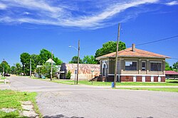
Morehouse is a city in New Madrid County, Missouri, United States. The population was 973 at the 2010 census.
Morehouse was established as a lumber camp in the 19th century. It was known as "Little River" from 1877 to 1887. When a post office was established in 1893, it was named "Morehouse" after Albert P. Morehouse, who served as the 26th Governor of Missouri from 1887 to 1889. [4]
Morehouse lies along Missouri Route 114 west of Sikeston. U.S. Route 60 passes along the city's southern boundary.
According to the United States Census Bureau, the city has a total area of 0.79 square miles (2.05 km2), all land. [5]
Census | Pop. | Note | %± |
---|---|---|---|
1900 | 900 | — | |
1910 | 1,636 | 81.8% | |
1920 | 1,913 | 16.9% | |
1930 | 1,165 | −39.1% | |
1940 | 1,598 | 37.2% | |
1950 | 1,635 | 2.3% | |
1960 | 1,417 | −13.3% | |
1970 | 1,332 | −6.0% | |
1980 | 1,220 | −8.4% | |
1990 | 1,068 | −12.5% | |
2000 | 1,015 | −5.0% | |
2010 | 973 | −4.1% | |
2020 | 741 | −23.8% | |
U.S. Decennial Census [6] |
As of the census [7] of 2010, there were 973 people, 426 households, and 268 families living in the city. The population density was 1,231.6 inhabitants per square mile (475.5/km2). There were 499 housing units at an average density of 631.6 per square mile (243.9/km2). The racial makeup of the city was 95.89% White, 0.82% Black or African American, 0.31% Native American, 0.10% Asian, 1.03% from other races, and 1.85% from two or more races. Hispanic or Latino of any race were 1.95% of the population.
There were 426 households, of which 27.2% had children under the age of 18 living with them, 41.5% were married couples living together, 13.1% had a female householder with no husband present, 8.2% had a male householder with no wife present, and 37.1% were non-families. 31.5% of all households were made up of individuals, and 14.6% had someone living alone who was 65 years of age or older. The average household size was 2.28 and the average family size was 2.82.
The median age in the city was 42.9 years. 21.5% of residents were under the age of 18; 6.6% were between the ages of 18 and 24; 24.9% were from 25 to 44; 30.1% were from 45 to 64; and 16.8% were 65 years of age or older. The gender makeup of the city was 48.6% male and 51.4% female.
As of the census [3] of 2000, there were 1,015 people, 428 households, and 294 families living in the city. The population density was 1,240.9 inhabitants per square mile (479.1/km2). There were 492 housing units at an average density of 601.5 per square mile (232.2/km2). The racial makeup of the city was 97.04% White, 0.49% African American, 0.30% Native American, 0.10% Asian, 0.69% from other races, and 1.38% from two or more races. Hispanic or Latino of any race were 2.56% of the population.
There were 428 households, out of which 26.9% had children under the age of 18 living with them, 53.3% were married couples living together, 9.8% had a female householder with no husband present, and 31.1% were non-families. 25.9% of all households were made up of individuals, and 15.0% had someone living alone who was 65 years of age or older. The average household size was 2.37 and the average family size was 2.80.
In the city the population was spread out, with 22.9% under the age of 18, 8.6% from 18 to 24, 27.4% from 25 to 44, 24.1% from 45 to 64, and 17.0% who were 65 years of age or older. The median age was 38 years. For every 100 females there were 88.0 males. For every 100 females age 18 and over, there were 86.9 males.
The median income for a household in the city was $24,931, and the median income for a family was $30,144. Males had a median income of $26,389 versus $17,941 for females. The per capita income for the city was $12,691. About 10.5% of families and 13.2% of the population were below the poverty line, including 9.0% of those under age 18 and 24.1% of those age 65 or over.
The Morehouse Elementary School is part of the Sikeston school system.
Morehouse has a lending library, a branch of the New Madrid County Library. [8]
Canalou is a city in New Madrid County, Missouri, United States. The population was 338 at the 2010 census. The ZIP code is 63828.
Catron is a city in New Madrid County, Missouri, United States. The population was 67 at the 2010 census.
Gideon is a city in New Madrid County, Missouri, United States. The population was 1,093 at the 2010 census.
Howardville is a city in New Madrid County, Missouri, United States. The population was 383 at the 2010 census.
Lilbourn is a city in New Madrid County, Missouri, United States. The population was 994 at the 2020 census.
Marston is a city in New Madrid County, Missouri, United States. The population was 503 at the 2010 census.
Matthews is a city in New Madrid County, Missouri, United States. The population was 628 at the 2010 census.
Risco is a city in New Madrid County, Missouri, United States. The population was 286 at the 2020 census.
Tallapoosa is a city in New Madrid County, Missouri, United States. The population was 78 at the 2020 census.
Cooter is a city in Pemiscot County, Missouri, United States. The population was 343 at the 2020 census.
Hayti is a city in eastern Pemiscot County, Missouri, United States. The population was 2,493 at the 2020 census.
Diehlstadt is a village in Scott County, Missouri, United States. The population was 161 at the 2010 census. Diehlstadt was founded by John Kirkpatrick.
Crystal Lake Park is a Missouri Class 4 city in St. Louis County, Missouri, United States. The population was 508 at the 2020 census.
Winchester is a city in St. Louis County, Missouri, United States. The population was 1,447 at the 2020 census.
Bell City is a city in northeastern Stoddard County, Missouri, United States. It was founded as a sawmill town circa 1900, and lies at the foothills of Crowley's Ridge on Missouri Route 91. The population was 448 at the 2010 census. Dorothy Burton is the current mayor.
Dexter is a city in Stoddard County, Missouri, United States, founded in 1873. The population was 7,864 at the 2010 census.
Essex is a city in Stoddard County, Missouri, United States. The population was 472 at the 2010 census.
Scott City is a city in Cape Girardeau and Scott counties in the U.S. state of Missouri. The population was 4,346 at the 2020 census. The Scott County portion of Scott City is part of the Sikeston Micropolitan Statistical Area, while the Cape Girardeau County portion is part of the Cape Girardeau–Jackson, MO-IL Metropolitan Statistical Area.
Miner is a city in Mississippi and Scott counties in the U.S. state of Missouri. It borders the city of Sikeston to the east. The population was 916 at the 2020 census.
Portageville is a city in New Madrid and Pemiscot counties in the U.S. state of Missouri. The population was 2,942 according to the 2020 Census.