Helen's Reef

Last updated

Helen's Reef
Oceans around British Isles satellite image location map.jpg
Red pog.svg
Helen's Reef
Location of Helen's Reef in Europe
Geography
LocationNorth-East Atlantic
Coordinates 57°36′5″N13°39′29″W / 57.60139°N 13.65806°W / 57.60139; -13.65806
Administration

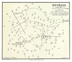
Helen's Reef is a series of skerries in the North Atlantic, 2 kilometres (1.1 nautical miles) northeast of the larger islet of Rockall and outcrop of Hasselwood Rock, within the United Kingdom's exclusive economic zone. The skerries are covered at high tide or in rough seas, and are often only visible as breaking waves.

It is within the 12-nautical-mile (22 km; 14 mi) radius territorial waters of Rockall, which is claimed by the UK as of 1955 and incorporated into the UK by the Island of Rockall Act 1972. This claim was previously long disputed by Ireland, [1] [2] but the dispute is resolved as of 31 March 2014. [3] [4]

History

In 1812 the survey vessel Leonidas foundered on the reef.[ citation needed ]

It was named for the brigantine Helen of Dundee, bound for Quebec, which foundered at Hasselwood Rock in 1824. [5] The vessel struck between nine and ten o'clock on the morning of 17 April. After some twelve hours struggling to keep her afloat and make for safety, water had almost filled the hold. The captain ordered the passengers onto the deck with warm clothing. Difficulty was experienced launching the boats, and one had to be repaired after being holed on the stock of the kedge anchor; [6]

On 28 June 1904 the 3,318 ton DFDS steamer SS Norge, with 795 people including 240 children on board bound for New York, foundered on the reef. 635 lives were lost with most of the 163 survivors being taken to Stornoway. [7] [8] [9] The wreck was found a century later in 65 metres (213 ft) of water. [10]

ROCKALL - Nautical chart - Atlantic Sea Pilot, 1884 IMRAY(1884) p0231 ROCKALL.jpg
ROCKALL - Nautical chart - Atlantic Sea Pilot, 1884

Related Research Articles

<span class="mw-page-title-main">Rockall</span> Uninhabited islet in the North Atlantic Ocean

Rockall is an uninhabitable granite islet in the North Atlantic Ocean. The United Kingdom claims that Rockall lies within its territorial sea and is part of its territory, but this claim is not recognised by Ireland. It and the nearby skerries of Hasselwood Rock and Helen's Reef are the only emergent parts of the Rockall Plateau. The rock was formed by magmatism as part of the North Atlantic Igneous Province during the Paleogene.

<span class="mw-page-title-main">Islet</span> Very small island

An islet is a very small, often unnamed island. Most definitions are not precise, but some suggest that an islet has little or no vegetation and cannot support human habitation. It may be made of rock, sand and/or hard coral; may be permanent or tidal ; and may exist in the sea, lakes, rivers or any other sizeable bodies of water.

<span class="mw-page-title-main">Territorial waters</span> Coastal waters that are part of a sovereign states sovereign territory

Territorial waters are informally an area of water where a sovereign state has jurisdiction, including internal waters, the territorial sea, the contiguous zone, the exclusive economic zone, and potentially the extended continental shelf. In a narrower sense, the term is often used as a synonym for the territorial sea.

<span class="mw-page-title-main">Exclusive economic zone</span> Adjacent sea zone in which a state has special rights

An exclusive economic zone (EEZ), as prescribed by the 1982 United Nations Convention on the Law of the Sea, is an area of the sea in which a sovereign state has exclusive rights regarding the exploration and use of marine resources, including energy production from water and wind. EEZ does not define the ownership of any maritime features within the EEZ.

<span class="mw-page-title-main">Scarborough Shoal</span> Disputed atoll in the South China Sea

Scarborough Shoal, also known as Bajo de Masinloc, Huangyan Island, Minzhu Jiao and Panatag Shoal, are two skerries (rocks) located between Macclesfield Bank to the west and Luzon to the east. Luzon is 220 kilometres (119 nmi) away and the nearest landmass. The atoll is a disputed territory claimed by the Republic of the Philippines through the 1734 Velarde map, while the People's Republic of China and the Republic of China (Taiwan) claim it through the disputed nine-dash line. The atoll's status is often discussed in conjunction with other territorial disputes in the South China Sea such as those involving the Spratly Islands, and the 2012 Scarborough Shoal standoff. It was administered by the Philippines as part of its Zambales province, until 2012, when a standoff was initiated by China through the use of warships against fishing boats, resulting in effective capture by the Chinese maritime forces.

<span class="mw-page-title-main">Okinotorishima</span> Reef in the Philippine Sea

Okinotorishima, or Parece Vela, is a coral reef, geologically an atoll, with two rocks enlarged with tetrapod-cement structures. It is administered by Japan with a total shoal area of 8,482 m2 and land area 9.44 m2 (101.6 sq ft). Its dry land area is mostly made up by three concrete encasings and there is a 100 by 50 m stilt platform in the lagoon housing a research station. There is a third completely artificial tetrapod-cement islet.

SS <i>Norge</i> Danish passenger liner

SSNorge was a transatlantic ocean liner that was launched in 1881 in Scotland, and lost in 1904 off Rockall with great loss of life. Her final voyage was from Copenhagen, Kristiania and Kristiansand, bound for New York, carrying passengers many of whom were emigrants. It was the biggest civilian maritime disaster in the Atlantic Ocean until the sinking of Titanic eight years later, and is still the largest loss of life from a Danish merchant ship.

<span class="mw-page-title-main">Socotra Rock</span> Disputed submerged rock in the Yellow Sea

Socotra Rock, also known as Ieodo, Parangdo, or Suyan Islet, is a submerged rock 4.6 metres (15 ft) below sea level located in the Yellow Sea. International maritime law stipulates that a submerged rock outside of a country's territorial sea cannot be claimed as territory by any country. However, the rock is the subject of a maritime dispute between China and South Korea, which consider it to lie within their respective exclusive economic zones.

<span class="mw-page-title-main">Argentine Sea</span> Sea within the continental shelf off the Argentine mainland

The Argentine Sea is a marginal sea of the Atlantic Ocean adjacent to the southern tip of South America. It ranges from the mouth of the estuary of the Río de la Plata in the north to the Isla de los Estados in the south, and from the Argentine coast to the 200 meters isobath. Its width varies between 210 km in front of Mar del Plata and 850 km at the latitude of the Falkland Islands. The coastline extends for 4,725 km. To the east of the Argentine Sea extends much deeper and more extensive Argentine Basin.

<span class="mw-page-title-main">Hasselwood Rock</span> Skerry in the North Atlantic ocean

Hasselwood Rock is a skerry adjacent to Rockall in the North Atlantic.

<span class="mw-page-title-main">South China Sea Arbitration</span> 2016 international arbitration case

The South China Sea Arbitration was an arbitration case brought by the Republic of the Philippines against the People's Republic of China (PRC) under Annex VII of the United Nations Convention on the Law of the Sea concerning certain issues in the South China Sea, including the nine-dash line introduced by the mainland-based Republic of China since as early as 1947. A tribunal of arbitrators appointed the Permanent Court of Arbitration (PCA) as the registry for the proceedings.

<span class="mw-page-title-main">Rockall Bank dispute</span> Conflicting maritime claims

Several states have claimed interests over the sea bed adjoining Rockall, an uninhabitable granite islet which is located within the exclusive economic zone (EEZ) of the United Kingdom. Ireland, Denmark, Iceland, and the United Kingdom have all made submissions to the commission set up under the United Nations Convention on the Law of the Sea (UNCLOS).

<span class="mw-page-title-main">Second Thomas Shoal</span> Attoll in the South China Sea

Second Thomas Shoal, also known as Ayungin Shoal, Bãi Cỏ Mây (Vietnamese) and Rén'ài Jiāo, is a submerged reef in the Spratly Islands of the South China Sea, 105 nautical miles west of Palawan, Philippines. It is a disputed territory and claimed by several nations. The reef is occupied by Philippine Navy personnel aboard ship, the BRP Sierra Madre (LT-57), that was intentionally grounded on the reef in 1999 and has been periodically replenished since then.

<span class="mw-page-title-main">Exclusive economic zone of the Philippines</span> Maritime economic zone

The Philippines has an exclusive economic zone that covers 2,263,816 square kilometers (874,064 sq mi) of sea. It claims an EEZ of 200 nautical miles (370 km) from its shores. This is due to the 7,641 islands comprising the Philippine archipelago. The coordinates are between 116° 40', and 126° 34' E longitude and 4° 40' and 21° 10' N latitude. It is bordered by the Philippine Sea to the east and north, the South China Sea to the west, and the Celebes Sea to the south.

<span class="mw-page-title-main">Exclusive economic zone of Vietnam</span> Economic zone exclusive to Vietnam

Vietnam claims an exclusive economic zone (EEZ) of 1,395,096 km2 (538,650 sq mi) with 200 nautical miles from its shores.

<span class="mw-page-title-main">Exclusive economic zone of the United Kingdom</span> Maritime boundary

The United Kingdom's exclusive economic zone is the fifth largest in the world at 6,805,586 km2 (2,627,651 sq mi). It comprises the exclusive economic zones surrounding the United Kingdom, the Crown Dependencies, and the British Overseas Territories. The figure does not include the EEZ of the British Antarctic Territory.

<span class="mw-page-title-main">Exclusive economic zone of India</span> Economic zone exclusive to India

India has the 18th-largest exclusive economic zone (EEZ) with a total size of 2,305,143 km2 (890,021 sq mi). It includes the Lakshadweep island group in the Laccadive Sea off the southwestern coast of India and the Andaman and Nicobar Islands in the Bay of Bengal and the Andaman Sea. India's EEZ is bordered to the west by Pakistan, to the south by the Maldives and Sri Lanka and to the east by Bangladesh, Myanmar, Thailand, Malaysia and Indonesia. Based on new scientific data, India has petitioned United Nations to extend its EEZ from 200 Nautical miles to 500 miles.

<span class="mw-page-title-main">2020 Palauan constitutional referendum</span>

A constitutional referendum was held in Palau on 1 May 2020. Voters were asked whether they approved of an amendment to article 1 of the constitution, which defined its maritime borders. The proposal was approved by 97% of voters.

The exclusive economic zone (EEZ) of Ireland extends 200 miles (320 km) from the coast. Exclusive economic zones are areas of internationally-recognised rights to conduct certain activities on areas of the high seas but do not give any power over access to those areas, including over shipping or military matters.

References

  1. Written Answers - Rockall Island Archived 12 March 2014 at the Wayback Machine . debates.oireachtas.ie 24 March 2011. Retrieved 6 April 2014.
  2. Clive Symmons "Ireland and the Rockall Dispute: An Analysis of Recent Developments" Durham University www.dur.ac.uk
  3. "The Exclusive Economic Zone Order 2013" www.legislation.gov.uk Retrieved 20 July 2014.
  4. "Maritime Jurisdiction (Boundaries of Exclusive Economic Zone) Order 2014" www.irishstatutebook.ie. Retrieved 20 July 2014.
  5. Lindsay, E.M. (1955) "An Early Astronomical Record of Rockall Island". Irish Astronomical Journal, Vol. 3, p. 202
  6. The Waterford Mirror from Waterford, May 22, 1824, Page 1, via www.newspapers.com (subscription needed for full access) Accessed 21 March 2020
  7. Keay, J. & Keay, J. (1994) Collins Encyclopaedia of Scotland . London. HarperCollins. ISBN   0002550822 p. 817
  8. "SS Norge Shipping Disaster". Findagrave.com. Retrieved 17 October 2013.
  9. "The Sinking of the Norge". Norway Heritage. May 2005. Retrieved 21 July 2012.
  10. Follett, Christopher (28 November 2016). "Watch out for the big rock: Remembering Denmark's greatest maritime disaster". Copenhagen Post. Retrieved 25 January 2022.