Cantabria is an autonomous community in northern Spain with Santander as its capital city. It is recognized as a historic community and is bordered on the east by the Basque Autonomous Community, on the south by Castile and León, on the west by the Principality of Asturias, and on the north by the Cantabrian Sea.

Aguilar de Campoo is a town in the province of Palencia, autonomous community of Castile and León, Spain. It is close to the River Pisuerga. Its 2011 population is 7741.
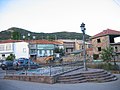
Unquera is a village with 803 inhabitants in the municipality of Val de San Vicente, in the west of the province of Cantabria, Spain. Sitting on the ría de Tina Menor, at the mouth of the River Deva it borders Asturias. It is famous throughout Spain for its pies of Unquera. Unquera is also known as the entrance to the Hermida gorge, the most usual way to access the Liébana district, which has become the main throughway of the town. This route is also part of the Camino Lebaniego, which links the Caminos de Santiago of the North and French route.

The designation artede (la) repoblación was first proposed by José Camón Aznar in 1949 to replace the term Mozarabic as applied to certain works of architecture from the Christian kingdoms of northern Spain between the end of the 9th and beginning of the 11th centuries. Camón argued that these buildings were related stylistically to the architecture of Asturias and owed little to Andalusian styles. Moreover, since they were built by Christians living under Christian rule, neither were they Mozarabic.

Aurora Matilde Gómez Camus was a Spanish poet from Cantabria who also wrote non-fiction.

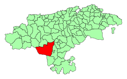
Reinosa is a municipality in Cantabria, Spain. As of 2009, it has 10,307 inhabitants. The municipality, one of the smallest by land area in Cantabria, is notable for being one of the nearest towns to the headwaters of the Ebro River. It is completely surrounded by the municipality of Campoo de Enmedio and was created a city by King Alfonso XIII in 1927, being one of only three urban centres in Cantabria with that honour, the others being Santander and Torrelavega.

Liébana is a comarca of Cantabria (Spain). It covers 575 square kilometres and is located in the far southwest of Cantabria, bordering Asturias, León and Palencia. It is made up of the municipalities of: Cabezón de Liébana, Camaleño, Cillorigo de Liébana, Pesaguero, Potes, Tresviso and Vega de Liébana.

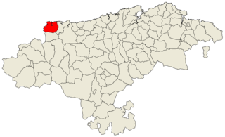
Campoo is a comarca of Cantabria (Spain) located in the High Ebro, with a surface little bigger than 1,000 km2, and including the municipalities of Hermandad de Campoo de Suso, Campoo de Enmedio, Campoo de Yuso, Valdeolea, Valdeprado del Río, Valderredible, Reinosa, Las Rozas de Valdearroyo, Santiurde de Reinosa, Pesquera, and San Miguel de Aguayo. Their inhabitants are called Campurrians . Its highest elevation is the Cuchillón peak, and the lowest is Pesquera, with the capital, Reinosa at 850 m.
Campoo de Enmedio is a municipality located in the autonomous community of Cantabria, Spain. According to the 2007 census, the city has a population of 3.996 inhabitants. Its capital is Matamorosa.

Campoo de Yuso is a municipality located in the autonomous community of Cantabria, Spain. According to the 2007 census, the city has a population of 759 inhabitants. Its capital is La Costana.

Fontibre is a locality of the municipality Hermandad de Campoo de Suso, in Cantabria. It is located 3 km from Reinosa.
Mozarabic art refers to art of Mozarabs, Iberian Christians living in Al-Andalus, the Muslim conquered territories in the period that comprises from the Arab invasion of the Iberian Peninsula (711) to the end of the 11th century, adopted some Arab customs without converting to Islam, preserving their religion and some ecclesiastical and judicial autonomy.
Corregimiento is a Spanish term used for country subdivisions for royal administrative purposes, ensuring districts were under crown control as opposed to local elites. A corregimiento was usually headed by a corregidor.
Riaño may refer to one of the following places in Spain:

Potes is a municipality in the autonomous community of Cantabria in Spain. It is the capital of the Comarca of Liébana and is located in the centre of it. It is bordered to the north by Cillorigo de Liébana, to the west by Camaleño, to the south by Vega de Liébana and to the east by Cabezón de Liébana.
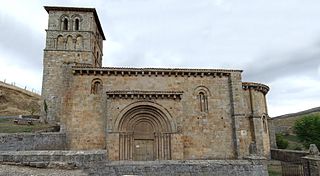
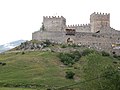
The Collegiate church of San Pedro de Cervatos is a collegiate church located in Campoo de Enmedio, Spain. The church was built around 1129. It has been protected by a heritage listing since 1895.
Val de San Vicente is a municipality located in the autonomous community of Cantabria, Spain.

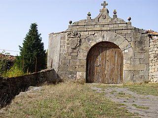
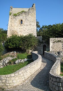
In Cantabria, there is a big number of fortified towers that fulfilled functions of housing and defense. These buildings, generally battlements, were erected mostly between the 13th and 15th centuries by noble families and influenced significantly in the architecture of Cantabria, passing some to be forts-houses, prelude to the future casona montañesa. A curious fact is that there are not in the region circular towers, as yes happens in the neighboring community of Asturias. Currently of the towers that survives several are in a deplorable condition.

Asturias de Santillana is a historical comarca whose territory in large part corresponded to the central and western part of today's autonomous community of Cantabria, as well as the extreme east of Asturias. Most of the province of Asturias belonged to the comarca of Asturias de Oviedo. Also known also as a merindad and documented since the 13th century, Asturias de Santillana comprised the western part of Cantabria including the Saja River valley and the Nansa River. Its borders used to go along the coast from the council of Ribadedeva to the municipality of El Astillero, to the shores of the Bay of Santander), which leads to the administrative division of Trasmiera. From the south it went up to the Cantabrian cordillera. All of the valleys of this comarca are perpendicular to the coast.