
Cantabria is an autonomous community and province in northern Spain with Santander as its capital city. It is called a comunidad histórica, a historic community, in its current Statute of Autonomy. It is bordered on the east by the Basque autonomous community, on the south by Castile and León, on the west by the Principality of Asturias, and on the north by the Cantabrian Sea, which forms part of the Bay of Biscay.

Cantabrian cuisine is the cuisine from Cantabria, an autonomous community in northern Spain. It includes seafood from the Cantabrian Sea, salmon and trout from the upper basins of the rivers, vegetables and dairy products from the valleys, and veal and game from the Cantabrian mountains.
Unquera is a village with 803 inhabitants in the municipality of Val de San Vicente, in the west of the province of Cantabria, Spain. Sitting on the ría de Tina Menor, at the mouth of the River Deva it borders Asturias. It is famous throughout Spain for its pies of Unquera. Unquera is also known as the entrance to the Hermida gorge, the most usual way to access the Liébana district, which has become the main throughway of the town. This route is also part of the Camino Lebaniego, which links the Caminos de Santiago of the North and French route.

The Battle of Santander was fought in the War in the North campaign of the Spanish Civil War during the summer of 1937. Santander's fall on 26 August assured the Nationalist conquest of the province of Santander, now Cantabria. The battle devastated the Republic's "Army of the North"; 60,000 soldiers were captured by the Nationalists.
The Western Coast of Cantabria is a comarca of said Spanish autonomous community which comprises the municipalities of Val de San Vicente, San Vicente de la Barquera, Valdáliga, Comillas, Udías, Ruiloba, Alfoz de Lloredo and Santillana del Mar.

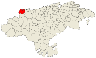
The Valleys of the Saja and Nansa Rivers comprise an administrative comarca in Cantabria, Spain. It is formed by the valleys of said rivers, each one being a natural comarca of its own.

Entrambasaguas is a small municipality located in the autonomous community of Cantabria, Spain, 25 km south of the Bay of Santander. It is moderately mountainous, and the origin of the Aguanaz River, which once drove 23 watermills and merges with the Miera River. Limestone caves with Paleolithic rock art and burial sites from the Bronze Age exist. Iron was mined here from prehistoric times, used in the Royal Artillery Factory of La Cavada, which supplied the Armada, and eventually brought some wealth during the Renaissance. First mentioned in 1210, this rural area of Green Spain consists of six towns an area of 43.2 square km, totaling about 5,000 inhabitants as of 2015, having nearly doubled since 2005.

Luena is a municipality located in the autonomous community of Cantabria, Spain. According to the 2007 census, the municipality has a population of 831 inhabitants. Its capital is San Miguel de Luena. The municipality consists of a valley which runs from the Cantabrian Mountains to the North, until it reaches the valley of the river Pas. It is a markedly rural area, where the traditional economic activity evolves around the cow.

El Soplao is a cave located in the municipalities of Rionansa, Valdáliga and Herrerías in Cantabria, Spain. It is considered unique for the quality and quantity of geological formations (speleothems) in its 17 miles length, 6 of which are open to the public. In it are formations such as helictites and curtains. Its formation dates back to the Mesozoic, in particular the Cretaceous period 240 million years ago. The entrance is at 540 metres in the Sierra Soplao Arnero.

The Cantabrian caves' unique location make them an ideal place to observe the settlements of early humans thousands of years ago. The magnificent art in the caves includes figures of various animals of the time such as bison, horses, goats, deer, cattle, hands and other paintings. Archaeologists have found remains of animals such as bears, the remains of arrows and other material indicating a human presence; these artifacts are now found mostly in the Regional Museum of Prehistory and Archaeology of Cantabria.

Potes is a municipality in the autonomous community of Cantabria in Spain. It is the capital of the Comarca of Liébana and is located in the centre of it. It is bordered to the north by Cillorigo de Liébana, to the west by Camaleño, to the south by Vega de Liébana and to the east by Cabezón de Liébana.

Salarzón is a locality of Cillorigo de Liébana municipality, in the Liébana region of Cantabria, Spain. It is located at 666 meters altitude and it is 6,8 kilometres far from Tama, the municipal capital. It has 33 inhabitants. This neighborhood belongs to "Bedoya's Council", formed by several villages placed in the Bedoya Valley, near the Cillorigo Valley, in the western slope of Rock Sagra, Cantabrian Mountains.

The 1983 Cantabrian regional election was held on Sunday, 8 May 1983, to elect the 1st Regional Assembly of the autonomous community of Cantabria. All 35 seats in the Regional Assembly were up for election. The election was held simultaneously with regional elections in twelve other autonomous communities and local elections all throughout Spain.

The 1991 Cantabrian regional election was held on Sunday, 26 May 1991, to elect the 3rd Regional Assembly of the autonomous community of Cantabria. All 39 seats in the Regional Assembly were up for election. The election was held simultaneously with regional elections in 12 other autonomous communities and local elections all throughout Spain.

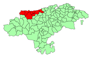
Asturias de Santillana is a historical comarca whose territory in large part corresponded to the central and western part of today's autonomous community of Cantabria, as well as the extreme east of Asturias. Most of the province of Asturias belonged to the comarca of Asturias de Oviedo. Also known also as a merindad and documented since the 13th century, Asturias de Santillana comprised the western part of Cantabria including the Saja River valley and the Nansa River. Its borders used to go along the coast from the council of Ribadedeva to the municipality of El Astillero, to the shores of the Bay of Santander), which leads to the administrative division of Trasmiera. From the south it went up to the Cantabrian cordillera. All of the valleys of this comarca are perpendicular to the coast.

Íñigo Joaquín de la Serna Hernáiz is a Spanish politician and civil engineer. He was the Mayor of Santander between 2007 and 2016 and served as Minister of Public Works from 4 November 2016 to 1 June 2018.
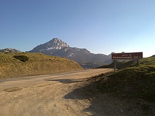
The Camino Real de la Valdavia is a historical route in Spain that joins the Way of St. James as it passes through Carrión de los Condes, with the Piedrasluengas pass through the valley of the Valdavia, and which was known and represented as such on maps until recent times.

Club Deportivo Barquereño is a Spanish football team based in San Vicente de la Barquera, in the autonomous community of Cantabria. Founded in 1953, it plays in Tercera Federación – Group 3, holding home matches at Campo Municipal El Castañar, with a capacity of 3,500 people.

The Hermandad of the Cuatro Villas de la Costa de la Mar, also cited under the name Cuatro Villas de la Costa de Cantabria, was a medieval and modern administrative entity that grouped the coastal cities of the north of the kingdom of Castile, all of them part of present-day Cantabria; namely, from west to east: San Vicente de la Barquera, Santander, Laredo, and Castro-Urdiales. At the end of the 15th century, it became part of the corregimiento of the Cuatro Villas along with other territories in the north of the Iberian Peninsula. In 1514 the province was renamed the corregimiento de las Tres Villas de la Costa, by separation from the town of San Vicente, which rejoined in 1521. Towns twinned since the 13th century, its foundation as a corregimiento dates back to the reign of the Catholic Monarchs, around 1496, surviving until its inclusion in the province of Cantabria in 1778.
Isaac Aja Muela was a Spanish businessman and politician. A member of the Socialist Party of Cantabria, he served in the Senate from 1986 to 1987. He previously was president of the Provisional Assembly of Cantabria, between 1982 and 1983, during the constitution of the Cantabrian Autonomy.


