Suances | |
|---|---|
| Suances | |
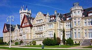
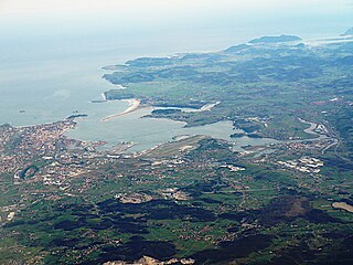
 View of the town of Suances, in Cantabria (Spain) | |
 Flag  Coat of arms | |
| Country | |
| Population (2018) [1] | |
| • Total | 8,716 |
| Website | |
Suances is a municipality in Cantabria Province, Spain. [2]
Suances | |
|---|---|
| Suances | |
| View of the town of Suances, in Cantabria (Spain) | |
| Flag Coat of arms | |
| Country | |
| Population (2018) [1] | |
| • Total | 8,716 |
| Website | |
Suances is a municipality in Cantabria Province, Spain. [2]
Suances is located in the central coast of Cantabria, in the Ría de San Martín de la Arena, where the rivers Saja and Besaya flow to the Cantabric sea. Suances has five beaches: La Tablía, Los Locos, La Concha, La Ribera and La Riberuca; and five islands (Los Conejos, La Pasiega, Casilda, Segunda and Solita), despite the location of these islands (in front of Miengo) they are part of Suances.
Suances has 8.552 inhabitants (INE, 2013) in six villages: Suances (5.034), Hinojedo (1.811), Cortiguera (817), Tagle (516), Ongayo (202) and Puente Avíos (172).
Suances is connected to the rest of Cantabria by two main autonomical roads (CA-132 to Viveda and CA-136 to Santillana del Mar), and four minor roads: CA-340, CA-341, CA-342 and CA-351.
Suances is connected to Torrelavega by the line Ubiarco-Torrelavega of Autobuses Casanova, and to Santander by the line Ubiarco-Santander of Autobuses La Cantábrica.
Andrés Ruiz Moya (PSOE) has been the mayor of Suances since 2007.
Due to the beaches and the hotels, Suances is the most important centre of tourism in the central coast of Cantabria. The touristic season starts in June and ends in October.
Suances and specially Los Locos beach are very popular surfing destinations for both local and international surf riders.
A very important monument is the cave of "Las Brujas", an archeological site of paintings made with the hands, from the Palaeolithic era.
The municipality has two listed properties: La Mota de Tres Palacios, a medieval fortification in Hinojedo; and the wall that surrounds the former convent of Trinitarias.

Cantabria is an autonomous community and province in northern Spain with Santander as its capital city. It is called a comunidad histórica, a historic community, in its current Statute of Autonomy. It is bordered on the east by the Basque autonomous community, on the south by Castile and León, on the west by the Principality of Asturias, and on the north by the Cantabrian Sea, which forms part of the Bay of Biscay.
Santander is the capital of the autonomous community of Cantabria, Spain. It has a population of 172,000 (2017). It is a port city located in the northern coast of the Iberian Peninsula, facing the Cantabrian Sea.

Laredo is a town in the autonomous community of Cantabria, Spain. According to the 2008 census (INE), the municipality has a population of 12,648 inhabitants. In addition to Laredo, the municipality includes the villages of La Arenosa, El Callejo, Las Cárcobas, Las Casillas, La Pesquera, Tarrueza and Villante. Except from the last two, the other villages had been physically integrated into Laredo.

Cantabrian cuisine is the cuisine from Cantabria, an autonomous community in northern Spain. It includes seafood from the Cantabrian Sea, salmon and trout from the upper basins of the rivers, vegetables and dairy products from the valleys, and veal and game from the Cantabrian mountains.
University of Cantabria (UC), is a public university located in Santander, Torrelavega and Comillas in Cantabria, Spain. It was founded in 1972 and is organized in 15 schools and colleges.

Torrelavega is a municipality and important industrial and commercial hub in the single province Autonomous Community of Cantabria, northern Spain.

The Battle of Santander was fought in the War in the North campaign of the Spanish Civil War during the summer of 1937. Santander's fall on 26 August assured the Nationalist conquest of the province of Santander, now Cantabria. The battle devastated the Republic's "Army of the North"; 60,000 soldiers were captured by the Nationalists.
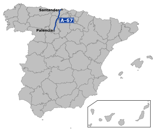
The Autovía A-67 is a highway in north west Spain. It connects the Cantabrian Atlantic Coast at Santander to Palencia. It follows the route of the N-611.

Reinosa is a municipality in Cantabria, Spain. As of 2009, it has 10,307 inhabitants. The municipality, one of the smallest by land area in Cantabria, is notable for being one of the nearest towns to the headwaters of the Ebro River. It is surrounded by the municipality of Campoo de Enmedio and was created a city by King Alfonso XIII in 1927, being one of only three urban centres in Cantabria with that honour, the others being Santander and Torrelavega.
The Bay of Santander is both a comarca of Cantabria and the largest estuary on the North coast of Spain, with an extension of 22.42 km2. Due to the influence of Santander and its metropolitan area, nearly half of the population of the autonomous community of Cantabria is gathered around it, which makes the anthropic pressure on this area of water quite notable.

Miguel Ángel Revilla Roiz is a Spanish politician, economist and bank employee. He served as 7th President of Cantabria from 2003 to 2011 and as the 9th president from 2015 to 2023, making him the longest serving holder of the office. He also served as the 5th Vice President of Cantabria from 1995 to 2003 and regional Minister of Public Works, Housing and Urbanism in the same period. Despite developing his political career at the regional level, he is very well known in national politics.

Entrambasaguas is a small municipality located in the autonomous community of Cantabria, Spain, 25 km south of the Bay of Santander. It is moderately mountainous, and the origin of the Aguanaz River, which once drove 23 watermills and merges with the Miera River. Limestone caves with Paleolithic rock art and burial sites from the Bronze Age exist. Iron was mined here from prehistoric times, used in the Royal Artillery Factory of La Cavada, which supplied the Armada, and eventually brought some wealth during the Renaissance. First mentioned in 1210, this rural area of Green Spain consists of six towns an area of 43.2 square km, totaling about 5,000 inhabitants as of 2015, having nearly doubled since 2005.

Val de San Vicente is a municipality located in the autonomous community of Cantabria, Spain.
In the run up to the 2015 Spanish local elections, various organisations carried out opinion polling to gauge voting intention in local entities in Spain. Results of such polls for municipalities in Cantabria are displayed in this article. The date range for these opinion polls is from the previous local elections, held on 22 May 2011, to the day the next elections were held, on 24 May 2015.
This is the results breakdown of the local elections held in Cantabria on 13 June 1999. The following tables show detailed results in the autonomous community's most populous municipalities, sorted alphabetically.
This is the results breakdown of the local elections held in Cantabria on 25 May 2003. The following tables show detailed results in the autonomous community's most populous municipalities, sorted alphabetically.
This is the results breakdown of the local elections held in Cantabria on 27 May 2007. The following tables show detailed results in the autonomous community's most populous municipalities, sorted alphabetically.
This is the results breakdown of the local elections held in Cantabria on 24 May 2015. The following tables show detailed results in the autonomous community's most populous municipalities, sorted alphabetically.
This is the results breakdown of the local elections held in Cantabria on 26 May 2019. The following tables show detailed results in the autonomous community's most populous municipalities, sorted alphabetically.

Viveda is a Lugar of the municipality of Santillana del Mar. It borders the towns of Barreda, Queveda and Camplengo, and Hinojedo. It is located 4 km from the municipal capital, Santillana del Mar, 3 km from the nearest city, Torrelavega, and about 22 km from Santander, Spain.
43°26′N4°03′W / 43.433°N 4.050°W
| International | |
|---|---|
| National | |
| Geographic | |
| | This article about a location in Cantabria is a stub. You can help Wikipedia by expanding it. |