Cádiz is a province of southern Spain, in the southwestern part of the autonomous community of Andalusia. It is the southernmost part of mainland Spain, as well as the southernmost part of continental Europe.

Isla Mujeres is an island where the Gulf of Mexico and the Caribbean Sea meet, about 13 kilometres (8.1 mi) off the Yucatán Peninsula coast in the State of Quintana Roo, Mexico. It is approximately 7 kilometres (4.3 mi) long and 650 metres (2,130 ft) wide. To the east is the Caribbean Sea with a strong surf and rocky coast, and to the west the skyline of Cancún can be seen across the waters. In the 2010 census, the namesake town on the island had a population of 12,642 inhabitants. The town is the seat of Isla Mujeres Municipality.

Mona is the third-largest island of the Puerto Rican archipelago, after the main island of Puerto Rico and Vieques. It is the largest of three islands in the Mona Passage, a strait between the Dominican Republic and Puerto Rico, the others being Monito Island and Desecheo Island. It measures about 7 miles by 4 miles, and lies 41 mi (66 km) west of Puerto Rico, of which it is administratively a part. It is one of two islands that make up the Isla de Mona e Islote Monito.
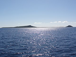
Caja de Muertos is an uninhabited island off the southern coast of Puerto Rico, in the municipality of Ponce. The island is protected by the Reserva Natural Caja de Muertos natural reserve, because of its native turtle traffic. Hikers and beachgoers are often seen in the island, which can be reached by ferry from the La Guancha Boardwalk sector of Ponce Playa. Together with Cardona, Ratones, Morrillito, Isla del Frio, Gatas, and Isla de Jueyes, Caja de Muertos is one of seven islands ascribed to the municipality of Ponce.

Águilas is a municipality and seaport of southeastern Spain, in the province of Murcia. It is situated at the southern end of Murcia's Mediterranean coastline, otherwise known as the Costa Cálida, near the border with the Province of Almería.
Del Rey or Delrey may refer to:

Nuevitas is a municipality and port town in the Camagüey Province of Cuba. The large bay was sighted by Christopher Columbus in 1492.

Valdegovía/Gaubea is a town and municipality located in the province of Álava, in the Basque Country, northern Spain.
Isla Contadora is a Panamanian island on the Pearl Islands archipelago in the Gulf of Panama. It has an area of 1.39 km², which makes it the 11th largest island of the archipelago. With a population of 253, however, it ranks third, after Isla del Rey and Isla Taboga. A popular tourist destination, Contadora has a small regional/domestic airport, and has regular flights to and from Panama City and the rest of the islands in the archipelago.

Pedasí is one of five districts of the Los Santos Province, Panama.
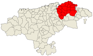
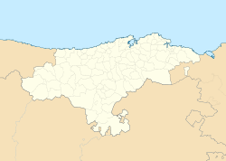
Trasmiera is a historic comarca of Cantabria (Spain), located to the east of the Miera River, reaching the western side of the Asón. It extends between the bays of Santander and Santoña, occupying most of the Eastern seaboard of Cantabria. This piece of coast is known for its cliffs and fine beaches, such as those of Langre, Loredo, Isla, Noja and Berria. Towards the interior, the comarca offers large prairies as well as considerable hotel and camping development.

Isla is a small village in the municipality of Arnuero in Cantabria, Spain together with other settlements, such as Soane, Castillo Siete Villas and Arnuero. It is in the region of Trasmiera.
Isla Municipality is a municipality in Veracruz, Mexico. It is located in south zone of the State of Veracruz, about 370 km from state capital Xalapa. It has a surface of 714.80 km2. It is located at 18°02′N95°32′W.
José Azueta Municipality is a municipality in Veracruz, Mexico.
Juan Rodríguez Clara is a Municipality in Veracruz, Mexico. It is located in south zone of the state, about 335 km from state capital Xalapa. It has a surface of 934.20 km2. It is located at 18°00′N95°24′W.
Playa Vicente is a municipality located in the south zone of the State of Veracruz, about 220 km from state capital Xalapa. It has a surface of 2,122.14 km2. It is located at 17°50′N95°49′W.

Isla Cardona, also known as Sor Isolina Ferré Island, is a small, uninhabited island located 1.30 nautical miles south of the mainland Puerto Rican shore across from Barrio Playa, on the west side of the entrance to the harbor of Ponce, Puerto Rico. The small island is considered part of barrio Playa. It is home to the 1889 Cardona Island Light, which is listed in the U.S. National Register of Historic Places. Together with Caja de Muertos, Gatas, Morrillito, Ratones, Isla del Frio, and Isla de Jueyes, Cardona is one of seven islands ascribed to the municipality of Ponce. The island gained notoriety in 2010 when the Puerto Rican Bird Society made it a target for the eradication of the black rat.

The Santa Olaja mill is located in the Joyel Marshes in Soano, in the municipality of Arnuero in the autonomous community of Cantabria, Spain. It was declared a Bien de Interés Cultural in November 2013.

La Demajagua is a Cuban village and consejo popular of the special municipality and province of Isla de la Juventud. With a population of 5,887 is the third most populated place of the island.