Herrick Township, Susquehanna County, Pennsylvania

Last updated
Herrick Township,
Susquehanna County,
Pennsylvania
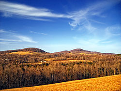
Flickr - Nicholas T - Knobbed.jpg
Map of Susquehanna County Pennsylvania highlighting Herrick Township.PNG
Map of Susquehanna County, Pennsylvania highlighting Herrick Township
Map of Pennsylvania highlighting Susquehanna County.svg
Country United States
State Pennsylvania
County Susquehanna
Settled1789
Incorporated1825
Area
[1]
  Total24.86 sq mi (64.40 km2)
  Land24.65 sq mi (63.84 km2)
  Water0.21 sq mi (0.56 km2)
Population
 (2020) [2]
  Total711 Decrease2.svg
  Estimate 
(2021) [2]
714
  Density27.91/sq mi (10.78/km2)
Time zone UTC-5 (Eastern (EST))
  Summer (DST) UTC-4 (EDT)
Area code 570
FIPS code 42-115-34096

Herrick Township is a township in Susquehanna County, Pennsylvania. The population was 711 at the 2020 census. [2]

Contents

History

Herrick Township was formed from parts of Gibson and Clifford Townships on April 20, 1825. [3]

Communities

The following villages are located in Herrick Township:

Geography

According to the U.S. Census Bureau, the township has a total area of 24.85 square miles (64.4 km2), of which 24.65 square miles (63.8 km2) is land and 0.2 square miles (0.52 km2) (1.24%) is water.

Demographics

Historical population
CensusPop.
2010 713
2020 711−0.3%
2021 (est.)714 [2] 0.4%
U.S. Decennial Census [9]

2000 census

At the 2000 census there were 599 people, 262 households, and 182 families living in the township. The population density was 24.3 people per square mile (9.4/km2). There were 685 housing units at an average density of 27.8/sq mi (10.7/km2). The racial makeup of the township was 97.33% White, 0.50% African American, 1.00% Native American, 0.50% Asian, and 0.67% from two or more races. Hispanic or Latino of any race were 1.00%. [10]

Of the 262 households 27.5% had children under the age of 18 living with them, 57.6% were married couples living together, 5.7% had a female householder with no husband present, and 30.5% were non-families. 26.3% of households were one person and 9.5% were one person aged 65 or older. The average household size was 2.29 and the average family size was 2.74.

The age distribution was 20.7% under the age of 18, 4.8% from 18 to 24, 26.4% from 25 to 44, 26.4% from 45 to 64, and 21.7% 65 or older. The median age was 44 years. For every 100 females there were 105.1 males. For every 100 females age 18 and over, there were 102.1 males. The median household income was $31,500 and the median family income was $43,500. Males had a median income of $31,071 versus $21,250 for females. The per capita income for the township was $20,974. About 4.4% of families and 6.1% of the population were below the poverty line, including none of those under age 18 and 20.8% of those age 65 or over.

2010 census

At the 2010 census there were 713 people, 308 households, and 217 families living in the township. The population density was 28.9 people per square mile (11.3/km2). There were 749 housing units at an average density of 30.4/sq mi (11.9/km2). The racial makeup of the township was 97.3% White, 0.6% African American, 0.3% Native American, 0.3% Asian, 0.7% from some other race, and 0.8% from two or more races. Hispanic or Latino of any race were 1.4%. [11]

Of the 308 households 25% had children under the age of 18 living with them, 58.4% were married couples living together, 5.8% had a female householder with no husband present, and 29.5% were non-families. 25% of households were one person and 8.7% were one person aged 65 or older. The average household size was 2.31 and the average family size was 2.71.

The age distribution was 18% under the age of 18, 61.7% from 18 to 64, and 20.3% 65 or older. The median age was 49 years. The median household income was $58,125 and the median family income was $60,069. Males had a median income of $53,500 versus $37,250 for females. The per capita income for the township was $32,337. About 3% of families and 4.5% of the population were below the poverty line, including 21.1% of those under age 18 and none of those age 65 or over.
Education

Forest City Regional School District is a Preschool-12th grade public school district serving residents of Herrick Township.

Related Research Articles

<span class="mw-page-title-main">Pike Township, Bradford County, Pennsylvania</span> Township in Pennsylvania, United States

Pike Township is a township in Bradford County, Pennsylvania, United States. The population was 671 at the 2010 census.

<span class="mw-page-title-main">Standing Stone Township, Bradford County, Pennsylvania</span> Township in Pennsylvania, United States

Standing Stone Township is a township in Bradford County, Pennsylvania, United States. The population was 642 at the 2010 census.

<span class="mw-page-title-main">Stevens Township, Bradford County, Pennsylvania</span> Township in Pennsylvania, United States

Stevens Township is a township in Bradford County, Pennsylvania, United States. The population was 437 at the 2010 census.

<span class="mw-page-title-main">Wyalusing Township, Bradford County, Pennsylvania</span> Township in Pennsylvania, United States

Wyalusing Township is a township in Bradford County, Pennsylvania, United States. The population was 1,242 at the 2010 census.

<span class="mw-page-title-main">Wysox Township, Bradford County, Pennsylvania</span> Township in Pennsylvania, United States

Wysox Township is a township in Bradford County, Pennsylvania, United States. The population was 1,721 at the 2010 census.

<span class="mw-page-title-main">Bastress Township, Lycoming County, Pennsylvania</span> Township in Pennsylvania, United States

Bastress Township is a township in Lycoming County, Pennsylvania, United States. The population was 528 at the 2020 census. It is part of the Williamsport, Pennsylvania Metropolitan Statistical Area.

<span class="mw-page-title-main">Susquehanna Township, Lycoming County, Pennsylvania</span> Township in Pennsylvania, United States

Susquehanna Township is a township in Lycoming County, Pennsylvania, United States. The population was 972 at the 2020 census. It is part of the Williamsport Metropolitan Statistical Area.

<span class="mw-page-title-main">Sergeant Township, McKean County, Pennsylvania</span> Township in Pennsylvania, United States

Sergeant Township is a township in McKean County, Pennsylvania, United States. The population was 146 at the 2020 census.

<span class="mw-page-title-main">Ararat Township, Susquehanna County, Pennsylvania</span> Township in Pennsylvania, United States

Ararat Township is a township in Susquehanna County, Pennsylvania, United States. The population was 526 at the 2020 census.

<span class="mw-page-title-main">Bridgewater Township, Susquehanna County, Pennsylvania</span> Township in Pennsylvania, United States

Bridgewater Township is a township in Susquehanna County, Pennsylvania, United States. The population was 2,582 at the 2020 census, but is now estimated to be 2,754.

<span class="mw-page-title-main">Choconut Township, Susquehanna County, Pennsylvania</span> Township in Pennsylvania, United States

Choconut Township is a township in Susquehanna County, Pennsylvania, United States. The population was 684 at the 2020 census.

<span class="mw-page-title-main">Franklin Township, Susquehanna County, Pennsylvania</span> Township in Pennsylvania, United States

Franklin Township is a township in Susquehanna County, Pennsylvania, United States. The population was 833 at the 2020 census. Salt Springs State Park, a Pennsylvania state park, is in Franklin Township.

<span class="mw-page-title-main">Gibson Township, Susquehanna County, Pennsylvania</span> Township in Pennsylvania, United States

Gibson Township is a township in Susquehanna County, Pennsylvania, United States. The population was 1,011 at the 2020 census.

<span class="mw-page-title-main">Lenox Township, Susquehanna County, Pennsylvania</span> Township in Pennsylvania, United States

Lenox Township is a township in Susquehanna County, Pennsylvania, United States. The population was 1,598 at the 2020 census.

<span class="mw-page-title-main">Middletown Township, Susquehanna County, Pennsylvania</span> Township in Pennsylvania, United States

Middletown Township is a township in Susquehanna County, Pennsylvania, United States. The population was 283 at the 2020 census.

<span class="mw-page-title-main">New Milford Township, Susquehanna County, Pennsylvania</span> Township in Pennsylvania, United States

New Milford Township is a township in Susquehanna County, Pennsylvania, United States. The population was 1,797 at the 2020 census. Children living in New Milford Township are served by the schools in the Blue Ridge School District, including Blue Ridge High School.

<span class="mw-page-title-main">Oakland Township, Susquehanna County, Pennsylvania</span> Township in Pennsylvania, United States

Oakland Township is a township in Susquehanna County, Pennsylvania, United States. The population was 492 at the 2020 census.

<span class="mw-page-title-main">Union Dale, Pennsylvania</span> Borough in Pennsylvania, United States

Union Dale is a borough in Susquehanna County, Pennsylvania, United States. The borough was incorporated in 1885. Union Dale's population was 267 at the 2010 census.

<span class="mw-page-title-main">Loyalhanna Township, Westmoreland County, Pennsylvania</span> Township in Pennsylvania, United States

Loyalhanna Township is a township in Westmoreland County, Pennsylvania, United States. As of the 2020 census, the township had a total population of 2,093.

<span class="mw-page-title-main">Shrewsbury Township, York County, Pennsylvania</span> Township in Pennsylvania, United States

Shrewsbury Township is a township in York County, Pennsylvania, United States. The population was 6,651 at the 2020 census.

References

  1. "2016 U.S. Gazetteer Files". United States Census Bureau. Retrieved Aug 14, 2017.
  2. 1 2 3 4 Bureau, US Census. "City and Town Population Totals: 2020—2021". Census.gov. US Census Bureau. Retrieved August 5, 2022.
  3. "Township Incorporations, 1790 to 1853". Susquehanna County Historical Society. Archived from the original on 23 June 2015. Retrieved 9 March 2013.
  4. 1 2 3 "HERRICK: SECOND CLASS TOWNSHIP MAP" (PDF). Pennsylvania Department of Transportation. Commonwealth of Pennsylvania. 5 August 2011. Retrieved 20 November 2014.
  5. "Dimock Corners". Geographic Names Information System . United States Geological Survey, United States Department of the Interior. 2 August 1979. Retrieved 20 November 2014.
  6. "Herrick Center". Geographic Names Information System . United States Geological Survey, United States Department of the Interior. 2 August 1979. Retrieved 20 November 2014.
  7. White, Israel Charles; Dolph, John M. (1881). The Geology of Susquehanna County and Wayne County (Report). Vol. 23. Board of Commissioners for the Second Geological Survey of Pennsylvania. p. 136. Retrieved 20 November 2014.
  8. "Tirzah". Geographic Names Information System . United States Geological Survey, United States Department of the Interior. 2 August 1979. Retrieved 20 November 2014.
  9. "Census of Population and Housing". Census.gov. Retrieved June 4, 2016.
  10. "U.S. Census website". United States Census Bureau . Retrieved 2008-01-31.
  11. "U.S. Census website". United States Census Bureau . Retrieved 2011-05-14.

Coordinates: 41°44′00″N75°28′59″W / 41.73333°N 75.48306°W / 41.73333; -75.48306