Lanesboro, Pennsylvania

Last updated
Lanesboro, Pennsylvania
HAER-Starrucca 1.jpg
Susquehanna County Pennsylvania Incorporated and Unincorporated areas Lanesboro Highlighted.svg
Location of Lanesboro in Susquehanna County, Pennsylvania.
USA Pennsylvania location map.svg
Red pog.svg
Lanesboro
Location in Pennsylvania
Usa edcp location map.svg
Red pog.svg
Lanesboro
Lanesboro (the United States)
Coordinates: 41°57′48″N75°34′55″W / 41.96333°N 75.58194°W / 41.96333; -75.58194 Coordinates: 41°57′48″N75°34′55″W / 41.96333°N 75.58194°W / 41.96333; -75.58194
CountryUnited States
StatePennsylvania
County Susquehanna
Established1888
Government
  MayorChris Maby
Area
[1]
  Total2.68 sq mi (6.95 km2)
  Land2.62 sq mi (6.78 km2)
  Water0.06 sq mi (0.17 km2)
Population
 (2020) [2]
  Total508
  Density194.12/sq mi (74.94/km2)
Time zone UTC-5 (EST)
  Summer (DST) UTC-4 (EDT)
Zip Code
18827, 18847
Area code 570
FIPS code 42-41336
Website lanesboropa.com

Lanesboro is a borough in Susquehanna County, Pennsylvania, United States. The population was 485 at the 2020 census. [3]

Contents

History

Lanesboro was named for Martin Lane, an early settler [4] who first called it Lanesville. The name was changed to Lanesboro by his son Jesse Lane. Lanesboro was incorporated as a borough in 1889. [5]

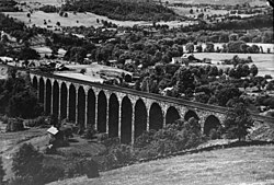
The Starrucca Viaduct was added to the National Register of Historic Places in 1975. [6]

Geography

Lanesboro is located at 41°57′48″N75°34′55″W / 41.96333°N 75.58194°W / 41.96333; -75.58194 (41.963293, -75.582034). [7]

According to the United States Census Bureau, the borough has a total area of 2.66 square miles (6.9 km2), of which 2.6 square miles (6.7 km2) is land and 0.06 square miles (0.16 km2) (2.26%) is water.

Demographics

Historical population
CensusPop.
1880 348
1890 876151.7%
1900 821−6.3%
1910 771−6.1%
1920 8054.4%
1930 731−9.2%
1940 637−12.9%
1950 591−7.2%
1960 502−15.1%
1970 5509.6%
1980 465−15.5%
1990 65941.7%
2000 588−10.8%
2010 506−13.9%
2020 485−4.2%
2021 (est.)482 [3] −0.6%
Sources: [8] [9] [10] [2]

2000 census

At the 2000 census there were 588 people, 248 households, and 149 families living in the borough. The population density was 230.6 inhabitants per square mile (89.0/km2). There were 278 housing units at an average density of 109.0 per square mile (42.1/km2). The racial makeup of the borough was 97.79% White, 0.17% Native American, 1.53% Asian, 0.17% Pacific Islander, and 0.34% from two or more races. Hispanic or Latino of any race were 0.68%. [9]

Of the 248 households 29.8% had children under the age of 18 living with them, 45.2% were married couples living together, 8.9% had a female householder with no husband present, and 39.9% were non-families. 33.9% of households were one person and 25.0% were one person aged 65 or older. The average household size was 2.37 and the average family size was 3.04.

The age distribution was 25.7% under the age of 18, 5.3% from 18 to 24, 24.5% from 25 to 44, 24.3% from 45 to 64, and 20.2% 65 or older. The median age was 42 years. For every 100 females, there were 80.4 males. For every 100 females age 18 and over, there were 75.5 males.

The median household income was $27,727 and the median family income was $34,844. Males had a median income of $30,750 versus $20,577 for females. The per capita income for the borough was $13,873. About 9.7% of families and 19.5% of the population were below the poverty line, including 17.3% of those under age 18 and 28.3% of those age 65 or over.

2010 census

At the 2010 census there were 506 people, 217 households, and 122 families living in the borough. The population density was 194.6 inhabitants per square mile (75.1/km2). There were 243 housing units at an average density of 93.5 per square mile (36.1/km2). The racial makeup of the borough was 96.4% White, 0.4% Black or African American, 0.4% Native American, 0.4% Asian, and 2.4% from two or more races. [11] Of the 217 households 26.7% had children under the age of 18 living with them, 37.8% were married couples living together, 13.4% had a female householder with no husband present, and 43.8% were non-families. 36.9% of households were one person and 24.9% were one person aged 65 or older. The average household size was 2.33 and the average family size was 3.02.

The age distribution was 25.7% under the age of 18, 53.7% from 18 to 64, and 20.6% 65 or older. The median age was 42.5 years.

The median household income was $29,083 and the median family income was $35,179. Males had a median income of $31,141 versus $28,409 for females. The per capita income for the borough was $16,319. About 25.2% of families and 19.6% of the population were below the poverty line, including 16.5% of those under age 18 and 40.9% of those age 65 or over.
Related Research Articles

<span class="mw-page-title-main">Lanesboro, Iowa</span> City in Iowa, United States

Lanesboro is a city in Carroll County, Iowa, United States. The population was 119 at the time of the 2020 census.

<span class="mw-page-title-main">Forest Hills, Kentucky</span> City in Kentucky, United States

Forest Hills is a home rule-class city in Jefferson County, Kentucky, United States. It was formally incorporated by the state assembly in 1959. The population was 444 at the 2010 census.

<span class="mw-page-title-main">Aurelius Township, Michigan</span> Civil township in Michigan, United States

Aurelius Township is a civil township of Ingham County in the U.S. state of Michigan. As of the 2010 census, the township population was 3,525, an increase from 3,318 at the 2000 census.

<span class="mw-page-title-main">Maplewood Park, Ohio</span> CDP in Ohio, United States

Maplewood Park is a census-designated place (CDP) in Trumbull County, Ohio, United States. The population was 321 at the 2000 census. It is part of the Youngstown–Warren–Boardman, OH-PA Metropolitan Statistical Area.

<span class="mw-page-title-main">Parryville, Pennsylvania</span> Borough in Pennsylvania, United States

Parryville is a borough in Carbon County, Pennsylvania. It is part of Northeastern Pennsylvania. The population was 416 at the 2020 census. It is located 3 miles (5 km) southeast of Lehighton and 1 mile (1.6 km) north of Bowmanstown off Route 248 and 4 miles (6 km) northwest of Palmerton. Parryville's elevation is 450 feet (140 m) above sea level.

<span class="mw-page-title-main">Modena, Pennsylvania</span> Borough in Pennsylvania, United States

Modena is a borough in Chester County, Pennsylvania, United States. The population was 544 at the 2020 census. It was originally called Modeville, after the local Mode family.

<span class="mw-page-title-main">South Coatesville, Pennsylvania</span> Borough in Pennsylvania, United States

South Coatesville is a borough in Chester County, Pennsylvania, United States. The population was 1,604 at the 2020 census.

<span class="mw-page-title-main">Westover, Pennsylvania</span> Borough in Pennsylvania, United States

Westover is a borough in Clearfield County, Pennsylvania, United States. The population was 359 at the 2020 census.

<span class="mw-page-title-main">Clarks Green, Pennsylvania</span> Borough in Pennsylvania, United States

Clarks Green is a borough in Lackawanna County, Pennsylvania. It is part of Northeastern Pennsylvania. The population was 1,529 at the 2020 census.

<span class="mw-page-title-main">Dupont, Pennsylvania</span> Borough in Pennsylvania, United States

Dupont is a borough in the Greater Pittston area of Luzerne County, Pennsylvania, United States. The population was 2,536 as of the 2020 census.

<span class="mw-page-title-main">Pringle, Pennsylvania</span> Borough in Pennsylvania, United States

Pringle is a borough in Luzerne County, Pennsylvania, United States. As of the 2020 census, the borough population was 891.

<span class="mw-page-title-main">West Wyoming, Pennsylvania</span> Borough in Pennsylvania, United States

West Wyoming is a borough in Luzerne County, Pennsylvania, United States. The borough is located within the Greater Pittston metro area. The population was 2,631 at the 2020 census.

<span class="mw-page-title-main">Yatesville, Pennsylvania</span> Borough in Pennsylvania, United States

Yatesville is a borough in the Greater Pittston area of Luzerne County, Pennsylvania. The population was 638 as of the 2020 census.

<span class="mw-page-title-main">Pennsburg, Pennsylvania</span> Borough in Pennsylvania, United States

Pennsburg is a borough in Montgomery County, Pennsylvania. Its population was 3,889 at the 2020 census. It is part of the Upper Perkiomen School District. It is also part of the strip of small towns that run together along Route 29: Red Hill, Pennsburg, and East Greenville. The towns are collectively referred to as Upper Perk.

<span class="mw-page-title-main">Tatamy, Pennsylvania</span> Place in Pennsylvania, United States

Tatamy is a borough in Northampton County, Pennsylvania. The borough's population was 1,203 as of the 2020 census. Tatamy is part of the Lehigh Valley metropolitan area, which had a population of 861,899 and was the 68th most populous metropolitan area in the U.S. as of the 2020 census.

<span class="mw-page-title-main">Walnutport, Pennsylvania</span> Place in Pennsylvania, United States

Walnutport is a borough in Northampton County, Pennsylvania. It was first incorporated in 1909. The population of Walnutport was 2,067 at the 2020 census.

<span class="mw-page-title-main">Wind Gap, Pennsylvania</span> Borough in Pennsylvania, United States

Wind Gap is a borough in Northampton County, Pennsylvania. The population of Wind Gap was 2,820 at the 2020 census. Wind Gap is part of the Lehigh Valley metropolitan area, which had a population of 861,899 and was the 68th most populous metropolitan area in the U.S. as of the 2020 census.

<span class="mw-page-title-main">Rouseville, Pennsylvania</span> Borough in Pennsylvania, United States

Rouseville is a borough in Venango County, Pennsylvania, United States. The population was 456 at the 2020 census.

<span class="mw-page-title-main">Prompton, Pennsylvania</span> Borough in Pennsylvania, United States

Prompton is a borough in Wayne County, Pennsylvania, United States. The population was 250 at the 2010 census.

<span class="mw-page-title-main">Poplar, Wisconsin</span> Village in Wisconsin, United States

Poplar is a village in Douglas County, Wisconsin, United States. The population was 603 at the 2010 census.

References

  1. "ArcGIS REST Services Directory". United States Census Bureau. Retrieved October 12, 2022.
  2. 1 2 "Census Population API". United States Census Bureau. Retrieved Oct 12, 2022.
  3. 1 2 Bureau, US Census. "City and Town Population Totals: 2020—2021". Census.gov. US Census Bureau. Retrieved August 5, 2022.
  4. Gannett, Henry (1905). The Origin of Certain Place Names in the United States. Government Printing Office. pp.  180.
  5. "Harmony Township". Susquehanna County Historical Society. Retrieved 18 January 2016.
  6. "National Register Information System". National Register of Historic Places . National Park Service. July 9, 2010.
  7. "US Gazetteer files: 2010, 2000, and 1990". United States Census Bureau. 2011-02-12. Retrieved 2011-04-23.
  8. "Census of Population and Housing". U.S. Census Bureau. Retrieved 11 December 2013.
  9. 1 2 "U.S. Census website". United States Census Bureau . Retrieved 2008-01-31.
  10. "Incorporated Places and Minor Civil Divisions Datasets: Subcounty Resident Population Estimates: April 1, 2010 to July 1, 2012". Population Estimates. U.S. Census Bureau. Archived from the original on 11 June 2013. Retrieved 11 December 2013.
  11. "U.S. Census website". United States Census Bureau . Retrieved 2011-05-14.