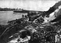
The Stone Arch Bridge is a former railroad bridge crossing the Mississippi River at Saint Anthony Falls in downtown Minneapolis, Minnesota. It is the only arched bridge made of stone on the entire Mississippi River. It is the second oldest bridge on the river next to Eads Bridge. The bridge was built to connect the railway system to the new Union Depot, which at that time was planned to be built between Hennepin Avenue and Nicollet Avenue. The bridge was completed in 1883, costing $650,000 at the time. 117 Portland Avenue is the general address of the historic complex.

The Hennepin Avenue Bridge is the structure that carries Hennepin County State Aid Highway 52, Hennepin Avenue, across the Mississippi River in Minneapolis, Minnesota, at Nicollet Island. Officially, it is the Father Louis Hennepin Bridge, in honor of the 17th-century explorer Louis Hennepin, who was the first European to see the Saint Anthony Falls, a short distance downriver. It is the fourth bridge on the site.

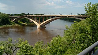
The Third Avenue Bridge is a landmark structure of the city of Minneapolis, Minnesota, United States, originally known as the St. Anthony Falls Bridge. It carries road traffic across the Mississippi River and upper fringes of Saint Anthony Falls. The multi-arched bridge meets with Third Avenue in downtown Minneapolis at its south end, but curves as it crosses the river, and connects with Central Avenue on its north end. The shallow "S" curve in the bridge was built to avoid fractures in the limestone bedrock that supports the bridge piers. The road is also designated Minnesota State Highway 65. Construction began in 1914, and it opened four years later in 1918. The bridge, which uses Melan arches of an open spandrel design, has been modified since that time. The 2,223-foot crossing was designed by city engineer Frederick W. Cappelen, who also created plans for other similar bridges in Minneapolis such as the Franklin Avenue Bridge. It cost US$862,254.00 at the time of construction.

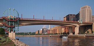
The Washington Avenue Bridge carries County Road 122 and the METRO Green Line light rail across the Mississippi River in Minneapolis and connects the East Bank and West Bank portions of the University of Minnesota campus. The bridge has two decks, with the lower deck designated for motor vehicle traffic and light rail trains and the upper deck used for pedestrians and bicycles. It is a utilitarian structure with simple architecture, but it has cultural significance because thousands of students, faculty, staff, and visitors walk across it every day.

The 10th Avenue Bridge crosses the Mississippi River near downtown Minneapolis, Minnesota and also in proximity to the University of Minnesota. The bridge was historically referred to as the Cedar Avenue Bridge in the days prior to the construction of the I-35W Mississippi River bridge when it connected to Cedar Ave. The bridge connects 10th Avenue Southeast, on the east side of the Mississippi River, to 19th Avenue South on the west side. The Seven Corners area of the Cedar-Riverside, Minneapolis neighborhood is at the southern end of the bridge. The downstream end of the lower Saint Anthony Falls lock and dam extends under the bridge. The historic Southeast Steam Plant is also located nearby.

The Stillwater Bridge is a vertical-lift bridge crossing the St. Croix River between Stillwater, Minnesota, and Houlton, Wisconsin. It formerly connected Minnesota State Highway 36 and Wisconsin Highway 64. Around 18,000 vehicles crossed the bridge daily. The new St. Croix Crossing bridge crossing the St. Croix river valley to the south of Stillwater replaced its purpose, having opened to highway traffic on August 2, 2017, leaving the Stillwater Lift Bridge to be preserved and to be converted to bicycle/pedestrian use.

Interstate 35W (I-35W) is an Interstate Highway in the US state of Minnesota, passing through downtown Minneapolis. It is one of two through routes for I-35 through the Twin Cities of Minneapolis and Saint Paul, the other being I-35E through downtown Saint Paul.

Minnesota State Highway 149 (MN 149) is a 9.924-mile-long (15.971 km) highway in Minnesota that runs from its intersection with State Highway 3 in Inver Grove Heights to its northern terminus at its intersection with State Highway 5 in Saint Paul.
The Wabasha Street Bridge is a segmental bridge that spans the Mississippi River in downtown Saint Paul, Minnesota, United States. It was named Wabasha Street Freedom Bridge in 2002, to commemorate the first anniversary of the September 11 attacks. It actually consists of two separate bridges, one for northbound and one for southbound traffic. The use of a concrete segmental box girder bridge provided a construction advantage because no falsework needed to be built beneath the bridge.

Minnesota State Highway 280 is a 3.710-mile-long (5.971 km) highway in the Twin Cities region of Minnesota that travels from its Interchange with Interstate 94/U.S.Route 12/US Route 52 (I-94/US 12/US 52) in Saint Paul to its interchange with I-35W in Roseville.

Ford Dam, officially known as Lock and Dam No. 1, is on the Upper Mississippi River and is located between Minneapolis and Saint Paul, Minnesota just north of the confluence of the Mississippi with the Minnesota River at Mississippi River mile 847.9, in Minneapolis. The powerhouse portion was previously owned by the Ford Motor Company, which operated a hydroelectric power station to feed electricity to its Twin Cities Assembly Plant on the east side of the river. It was sold to Brookfield Power Co. in April 2008. The dual-lock facility and dam was built and is operated by the St. Paul district of the U.S. Army Corps of Engineers' Mississippi Valley Division.
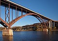
The Lake Street–Marshall Avenue Bridge is a reinforced concrete arch bridge that spans the Mississippi River between Minneapolis, Minnesota and St. Paul, Minnesota. It is oriented east-west and connects Lake Street in Minneapolis to Marshall Avenue in St. Paul. St. Paul residents often refer to it as the Marshall Avenue Bridge. The bridge was designed by Howard, Needles, Tammen, and Bergendoff.

Main Channel Bridge (Winona) consists of a pair of bridges, the original cantilever bridge, and a concrete box girder bridge completed in 2016, that span the main channel of the Mississippi River in the United States between Winona, Minnesota, and Latsch Island. Another bridge, the North Channel Bridge, connects the island to rural Buffalo County, Wisconsin. The bridge carries Minnesota State Highway 43, which continues as Wisconsin Highway 54 at the Minnesota/Wisconsin state line on the nearby North Channel Bridge; in Winona, it connects to Winona Street.

The Plymouth Avenue Bridge is a segmental bridge that spans the Mississippi River in Minneapolis. It was built in 1983 and was designed by Van Doren-Hazard-Stallings. The construction of this bridge was unique, for it was the first segmental concrete girder bridge built in Minnesota. This method of design uses a "form traveler" that shapes the concrete as it is built out from the piers. This avoided the use of falsework and avoided impeding river traffic. The concrete is also engineered to be salt-resistant by the use of post-tensioning. Tubes run through the concrete structure carrying strands of cable. With tension on the cables, the structure is designed to be under compression. This prevents cracks and hinders the intrusion of salt water. Since then, other bridges in Minnesota have used this construction method, including the I-35W Saint Anthony Falls Bridge in Minneapolis, the Wabasha Street Bridge in downtown St. Paul, and the Wakota Bridge in South St. Paul.

Broadway Avenue Bridge is a girder bridge that spans the Mississippi River in Minneapolis, Minnesota. Designed by Norman C. Davis and Shawn Pierson Bruns of Van Doren-Hazard-Stallings, it was built in 1987. The bridge has a rather streamlined shape, but its piers are more ornate. The piers have two flat columns that taper together, with a base that extends out to the full width of the bridge.

The I-35W Mississippi River bridge was an eight-lane, steel truss arch bridge that carried Interstate 35W across the Mississippi River one-half mile downstream from the Saint Anthony Falls in Minneapolis, Minnesota, United States. The bridge opened in 1967, and was Minnesota's third busiest, carrying 140,000 vehicles daily. After only 39 years in service, it experienced a catastrophic failure during the evening rush hour on August 1, 2007, killing 13 people and injuring 145. The National Transportation Safety Board (NTSB) cited a design flaw as the likely cause of the collapse, noting that an excessively thin gusset plate ripped along a line of rivets. Additional weight on the bridge at the time of failure was also cited by the NTSB as a contributing factor.

The I-35W Saint Anthony Falls Bridge crosses the Mississippi River one-half mile downstream from the Saint Anthony Falls in Minneapolis, Minnesota in the U.S., carrying north–south traffic on Interstate 35W. The ten-lane bridge replaced the I-35W Mississippi River bridge, which collapsed on August 1, 2007. It was planned and is maintained by the Minnesota Department of Transportation (MnDOT). The planning, design, and construction processes were completed more quickly than normal because Interstate 35W is a critical artery for commuters and truck freight. The bridge opened September 18, 2008, well ahead of the original goal of December 24.

The Rock Island Swing Bridge was a swing bridge that spanned the Mississippi River between Inver Grove Heights, Minnesota, and St. Paul Park, Minnesota. It was also known as the Newport Rail Bridge, as it had a spur to Newport, Minnesota, and J.A.R. bridge, after previous owners Joan and Al Roman of Chicago. It was one of the few double-decker bridges on the Mississippi, with the top level formerly used for railroad traffic and the bottom level formerly used as a road crossing. It also was one of a few toll bridges in Minnesota, and one of the last remaining ones. It closed to rail traffic in 1980, and road traffic in 1999, when the toll was 75 cents. After closing, the bridge sat dormant in the open position for 10 years before being partially demolished in 2009. It was converted into a recreational pier, which was open to the public on June 11, 2011.

The Dodd Ford Bridge is a bridge spanning the Blue Earth River about 1 mile (2 km) southwest of Amboy, Minnesota, in Blue Earth County, Minnesota.

Selby Avenue is a street in Saint Paul, Minnesota, United States, that runs east–west from Summit Avenue near downtown toward the Mississippi River. The street runs through the Summit-University and Union Park neighborhoods. The street, especially between Dale Street and Snelling Avenue, has been associated with Saint Paul's black community. The far eastern end of the street has historically been more densely developed and architecturally significant.