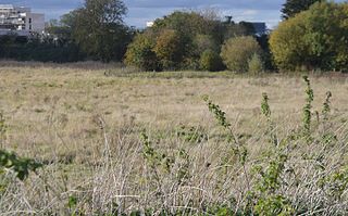
Histon Road SSSI

Last updated
Histon Road
Site of Special Scientific Interest
Histon Road 1.jpg
Area of Search Cambridgeshire
Grid reference TL 443 611 [1]
InterestGeological
Area0.6 hectares [1]
Notification 1984 [1]
Location map Magic Map

Histon Road is a 0.6 hectare geological Site of Special Scientific Interest in Cambridge. [1] [2] It is a Geological Conservation Review site. [3]

Site of Special Scientific Interest Conservation designation denoting a protected area in the United Kingdom

A Site of Special Scientific Interest (SSSI) in Great Britain or an Area of Special Scientific Interest (ASSI) in the Isle of Man and Northern Ireland is a conservation designation denoting a protected area in the United Kingdom and Isle of Man. SSSI/ASSIs are the basic building block of site-based nature conservation legislation and most other legal nature/geological conservation designations in the United Kingdom are based upon them, including national nature reserves, Ramsar sites, Special Protection Areas, and Special Areas of Conservation. The acronym "SSSI" is often pronounced "triple-S I".

Cambridge City and non-metropolitan district in England

Cambridge is a university city and the county town of Cambridgeshire, England, on the River Cam approximately 50 miles (80 km) north of London. At the United Kingdom Census 2011, its population was 123,867 including 24,506 students. Cambridge became an important trading centre during the Roman and Viking ages, and there is archaeological evidence of settlement in the area as early as the Bronze Age. The first town charters were granted in the 12th century, although modern city status was not officially conferred until 1951.

The Geological Conservation Review (GCR) is produced by the UK's Joint Nature Conservation Committee and is designed to identify those sites of national and international importance needed to show all the key scientific elements of the geological and geomorphological features of Britain. These sites display sediments, rocks, minerals, fossils, and features of the landscape that make a special contribution to an understanding and appreciation of Earth science and the geological history of Britain, which stretches back more than three billion years. The intention of the project, which was devised in 1974 by George Black and William Wimbledon working for the Governmental advisory agency, the Nature Conservancy Council (NCC), was activated in 1977. It aimed to provide the scientific rationale and information base for the conservation of geological SSSIs (Sites of Special Scientific Interest, protected under British law. The NCC and country conservation agencies were established in 1990 when JNCC became established and took over responsibility for managing the GCR site assessment process, and publishing accounts of accepted sites.

Histon Road is described by Natural England as a "key Pleistocene stratigraphic site". It is one only two sites in East Anglia which has an almost complete sequence of the second half of the warm Eemian interglacial, around 120,000 years ago. There are many deposits of molluscs and pollen. [4]

Natural England is a non-departmental public body in the United Kingdom sponsored by the Department for Environment, Food and Rural Affairs. It is responsible for ensuring that England's natural environment, including its land, flora and fauna, freshwater and marine environments, geology and soils, are protected and improved. It also has a responsibility to help people enjoy, understand and access the natural environment.

The Pleistocene is the geological epoch which lasted from about 2,588,000 to 11,700 years ago, spanning the world's most recent period of repeated glaciations. The end of the Pleistocene corresponds with the end of the last glacial period and also with the end of the Paleolithic age used in archaeology.

East Anglia region of the United Kingdom of Great Britain and Northern Ireland

East Anglia is a geographical area in the East of England. The area included has varied but the legally defined NUTS 2 statistical unit comprises the counties of Norfolk, Suffolk and Cambridgeshire, including the City of Peterborough unitary authority area. The name derives from the Anglo-Saxon kingdom of the East Angles, a tribe whose name originated in Anglia, northern Germany.

The site has been filled in and is now allotments. [4] There is no public access.

Allotment (gardening) a plot of land sub-divided into smaller parcels for individual, non-commercial gardening or growing of food plants

An allotment garden, often called simply an allotment, or a “community garden”, is a plot of land made available for individual, non-commercial gardening or growing food plants. Such plots are formed by subdividing a piece of land into a few or up to several hundred land parcels that are assigned to individuals or families. Such parcels are cultivated individually, contrary to other community garden types where the entire area is tended collectively by a group of people. In countries that do not use the term “allotment (garden)”, a “community garden” may refer to individual small garden plots as well as to a single, large piece of land gardened collectively by a group of people. The term “victory garden” is also still sometimes used, especially when a community garden dates back to the First or Second World War.

Related Research Articles

Adventurers Land

Adventurers' Land is a 10.1 hectare geological Site of Special Scientific Interest (SSSI) north of March in Cambridgeshire. It is a Geological Conservation Review site.

Bramerton Pits

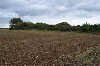
Bramerton Pits is a 0.7-hectare (1.7-acre) geological Site of Special Scientific Interest north of the village of Bramerton in Norfolk on the southern banks of the River Yare. It is a Geological Conservation Review site.
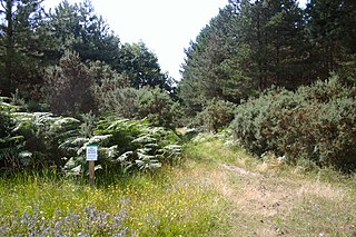
Travellers Rest Pit

Traveller's Rest Pit is a 2.2 hectare geological Site of Special Scientific Interest on the western outskirts of Cambridge. It is a Geological Conservation Review site.
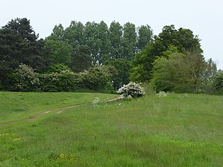
Eye Gravel Pit

Eye Gravel Pit is a 0.4 hectare geological Site of Special Scientific Interest in Eye Green in Cambridgeshire. It is a Geological Conservation Review site, and part of it overlaps Eye Green Local Nature Reserve.

Shippea Hill SSSI

Shippea Hill SSSI is a 27.6 hectare geological Site of Special Scientific Interest east of Ely in Cambridgeshire. It is a Geological Conservation Review site.

Flixton Quarry

Flixton Quarry is a 0.7 hectare geological Site of Special Scientific Interest south-west of Bungay in Suffolk. It is a Geological Conservation Review site.

Neutral Farm Pit, Butley

Neutral Farm Pit, Butley is a 1.1 hectare geological Site of Special Scientific Interest in Butley, east of Woodbridge in Suffolk. It is a Geological Conservation Review site, and is in the Suffolk Coast and Heaths Area of Outstanding Natural Beauty.

Breckland Forest

Breckland Forest is an 18,126 hectare biological and geological Site of Special Scientific Interest in many separate areas between Swaffham in Norfolk and Bury St Edmunds in Suffolk. It is part of the Breckland Special Protection Area under the European Union Directive on the Conservation of Wild Birds. It contains two Geological Conservation Review sites, Beeches Pit, Icklingham and High Lodge. Barton Mills Valley is a Local Nature Reserve in the south-west corner of the site.

Great Blakenham Pit

Great Blakenham Pit is a 2.2 hectare geological Site of Special Scientific Interest south of Great Blakenham in Suffolk. It is a Geological Conservation Review site.

Bawsey SSSI

Bawsey is a 2.6-hectare (6.4-acre) geological Site of Special Scientific Interest east of Kings' Lynn in Norfolk. It is a Geological Conservation Review site.

Hunstanton Park Esker

Hunstanton Park Esker is a 17.3-hectare (43-acre) geological Site of Special Scientific Interest east of Hunstanton in Norfolk. It is a Geological Conservation Review site.

Holkham Brick Pit

Holkham Brick Pit is a 0.5-hectare (1.2-acre) geological Site of Special Scientific Interest west of Wells-next-the-Sea in Norfolk. It is a Geological Conservation Review site, and it is in the Norfolk Coast Area of Outstanding Natural Beauty.

Morston Cliff

SSSI NORFOLK GEOLOGICAL

Wells Chalk Pit

Wells Chalk Pit is a 4-hectare (9.9-acre) biological and geological Site of Special Scientific Interest on the eastern outskirts of Wells-next-the-Sea in Norfolk. It is a Geological Conservation Review site, and it is in the Norfolk Coast Area of Outstanding Natural Beauty.

Overstrand Cliffs

Overstrand Cliffs is a 57.8-hectare (143-acre) biological and geological Site of Special Scientific Interest in Cromer in Norfolk. It is a Special Area of Conservation and part of it is a Geological Conservation Review site.

Wretton SSSI

Wretton SSSI is a 20.6-hectare (51-acre) geological Site of Special Scientific Interest north-east of Downham Market in Norfolk. It is a Geological Conservation Review site.

Broome Heath Pit

Broome Heath Pit is a 1.2-hectare (3.0-acre) geological Site of Special Scientific Interest east of Ditchingham in Norfolk. It is a Geological Conservation Review site and part of Broome Heath Local Nature Reserve

Beeston Cliffs

Beeston Cliffs is a 10.3-hectare (25-acre) biological and geological Site of Special Scientific Interest in Sheringham in Norfolk. It is a Geological Conservation Review site.

Glandford (Letheringsett Road)

Glandford is a 1.1-hectare (2.7-acre) geological Site of Special Scientific Interest west of Sheringham in Norfolk. It is a Geological Conservation Review site and it is in the Norfolk Coast Area of Outstanding Natural Beauty.

Weybourne Town Pit

Weybourne Town Pit is a 0.7-hectare (1.7-acre) geological Site of Special Scientific Interest west of Sheringham in Norfolk. It is a Geological Conservation Review site and it is in the Norfolk Coast Area of Outstanding Natural Beauty.

References

  1. 1 2 3 4 "Designated Sites View: Histon Road". Sites of Special Scientific Interest. Natural England. Retrieved 26 October 2016.
  2. "Map of Histon Road". Sites of Special Scientific Interest. Natural England. Retrieved 26 October 2016.
  3. "Histon Road (Quaternary of East Anglia)". Joint Nature Conservation Committee. Retrieved 26 October 2016.
  4. 1 2 "Histon Road citation" (PDF). Sites of Special Scientific Interest. Natural England. Retrieved 26 October 2016.

Coordinates: 52°13′44″N0°06′43″E / 52.229°N 0.112°E / 52.229; 0.112

Geographic coordinate system Coordinate system

A geographic coordinate system is a coordinate system that enables every location on Earth to be specified by a set of numbers, letters or symbols. The coordinates are often chosen such that one of the numbers represents a vertical position and two or three of the numbers represent a horizontal position; alternatively, a geographic position may be expressed in a combined three-dimensional Cartesian vector. A common choice of coordinates is latitude, longitude and elevation. To specify a location on a plane requires a map projection.