
The Great Fen is a habitat restoration project being undertaken on The Fens in the county of Cambridgeshire in England. It is one of the largest restoration projects in the country, and aims to create a 3,700 hectare wetland and aims to connect Woodwalton Fen National Nature Reserve (NNR), Holme Fen NNR and other nature reserves to create a larger site with conservation benefits for wildlife and socio-economic benefits for people.

Adventurers' Land is a 10.1-hectare (25-acre) geological Site of Special Scientific Interest (SSSI) north of March in Cambridgeshire. It is a Geological Conservation Review site.
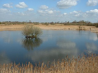
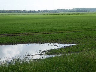
Holme Fen is a 269.4-hectare (666-acre) biological Site of Special Scientific Interest near Holme in Cambridgeshire. It is also a National Nature Reserve and a Nature Conservation Review site, Grade I. It is part of the Great Fen project, which aims to create a 3,700-hectare wetland wildlife area including Holme Fen, Woodwalton Fen and other areas. It is home to a variety of birds, including the Eurasian siskin, Nightingale and Lesser redpoll, and around 450 species of fungi.

Roswell Pits is an 8 hectare nature reserve on the eastern outskirts of Ely in Cambridgeshire. It is managed by the Environment Agency. It is part of the Ely Pits and Meadows Site of Special Scientific Interest (SSSI)) and Geological Conservation Review site. The SSSI designation for both biological and geological interest. The site was formerly managed by the Wildlife Trust for Bedfordshire, Cambridgeshire and Northamptonshire.
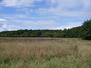
Woodwalton Fen is a 209-hectare biological Site of Special Scientific Interest in the parish of Woodwalton, west of Ramsey in Huntingdonshire, Cambridgeshire, England. It is a Ramsar wetland site of international importance, a National Nature Reserve, a Special Area of Conservation and a Nature Conservation Review site, Grade I. The site is managed by Natural England and owned by the Wildlife Trust for Bedfordshire, Cambridgeshire and Northamptonshire.

Blo' Norton and Thelnetham Fens are a 21.3-hectare (53-acre) biological Site of Special Scientific Interest (SSSI) on the Norfolk/Suffolk border. Blo' Norton Fen is in the parish of Blo' Norton in Norfolk and Thelnetham Fen is in Thelnetham parish in Suffolk. It is a Nature Conservation Review site, Grade 2, and part of the Waveney and Little Ouse Valley Fens Special Area of Conservation, Thelnetham Fen is managed by the Suffolk Wildlife Trust and Blo' Norton Fen by the Little Ouse Headwaters Project (LOHP).

The Crouch and Roach Estuaries are a 1729 hectare biological Site of Special Scientific Interest (SSSI) at the mouth of the Crouch and Roach rivers in Essex. The Crouch part of the SSSI stretches from near Battlesbridge to Foulness Island, and the Roach from Rochford to the junction with the Crouch. Part of the site is in the Mid-Essex Coast Special Protection Area under the EC Directive on the Conservation of Wild Birds, and a Ramsar wetland site of international importance. It is also part of the Essex Estuaries Special Area of Conservation. An area of 65 hectares is managed by the Essex Wildlife Trust as the Lion Creek and Lower Raypits nature reserve and 8 hectares at Woodham Fen, both of which are managed by the Essex Wildlife Trust. A small area is also a geological SSSI, The Cliff, Burnham-on-Crouch.
The River Ter SSSI is a stretch of the River Ter and its banks south of Great Leighs in Essex which has been designated a geological Site of Special Scientific Interest. It is a Geological Conservation Review site.
Upware South Pit is a 1.1-hectare (2.7-acre) geological Site of Special Scientific Interest (SSSI) north of Upware in Cambridgeshire. It is a Geological Conservation Review site.
Chippenham Fen and Snailwell Poor's Fen is a 155.9-hectare (385-acre) biological Site of Special Scientific Interest south-east of Fordham in Cambridgeshire, England. It is a Nature Conservation Review site, Grade I, a Ramsar wetland site and a Special Area of Conservation. It is managed by Natural England.
Setchey SSSI is a 33.4-hectare (83-acre) geological Site of Special Scientific Interest south of King's Lynn in Norfolk. It is a Geological Conservation Review site.
Cranberry Rough is an 81.1-hectare (200-acre) biological and geological Site of Special Scientific Interest in the parish of Hockham, east of Attleborough in Norfolk. It is a Nature Conservation Review site, Grade 2, and the Great Eastern Pingo Trail, which is a Local Nature Reserve, goes through the site. Part of it is a Geological Conservation Review site, and it is part of the Breckland Special Protection Area.

Cothill Fen is a 43.3-hectare (107-acre) biological and geological Site of Special Scientific Interest north-west of Abingdon-on-Thames in Oxfordshire. It is a Special Area of Conservation and parts of it are a Geological Conservation Review site, a Nature Conservation Review site, Grade 1, and a National Nature Reserve. It also includes two areas which are nature reserves managed by the Berkshire, Buckinghamshire and Oxfordshire Wildlife Trust, Lashford Lane Fen and Parsonage Moor.
