This article has no lead section .(June 2024) |
| History of Seattle |
|---|
History of Seattle, Washington 1900–1940
This article has no lead section .(June 2024) |
| History of Seattle |
|---|
History of Seattle, Washington 1900–1940


The gold rush (see History of Seattle before 1900) led to massive immigration, with major arrivals of Japanese, Filipinos, immigrant Europeans, and European-Americans from back east. The arrival of Greeks and Sephardic Jews broadened the city's ethnic mix.
Many of Seattle's neighborhoods got their start around this time. At first, the city grew mainly along the water to the north and south of downtown to avoid steep grades. However, the new rich soon developed the land on First Hill that overlooks downtown "because it was close to downtown without being a part of it, and because it occupied a commanding position." [1]
Downtown Seattle was bustling with activity; as quickly as previous inhabitants moved out to newly created neighborhoods, new immigrants came in to take their place in the city core. There was an enormous apartment boom in the years after 1905. A 1905 city directory lists only 19 apartment buildings. The 1911 directory has twelve columns of such listings. [2]
The last great manhunt of the Wild West was the search for Harry Tracy in Seattle in 1902.
In 1908, the Great White Fleet visited Seattle and the US West Coast, "to demonstrate to the world America's naval prowess. [3]
Construction on the Smith Tower was completed in 1914. It was the tallest building west of the Mississippi River from its completion in 1914 until the Space Needle overtook it in 1962. It remained the tallest office building west of the Mississippi River until the Humble Building (now Exxon Building) was built in 1963.
Following the vision of city engineer R.H. Thomson, who had already played a key role in the development of municipal utilities, a massive effort was made to level the extreme hills that rose south and north of the bustling city. From 1900 to 1914 the Denny Regrade to the north and the Jackson Regrade to the south leveled more than 120 feet (37 m) of Denny Hill and parts of First and Beacon Hills. The Denny Regrade continued in spurts until 1930. Dirt from the Jackson Regrade filled in the swampy tidelands that are now occupied by the SoDo neighborhood as well as Safeco Field and Qwest Field. A seawall containing dirt from the Denny Regrade created the current waterfront. More dirt from the Denny Regrade went to build the industrial Harbor Island at the mouth of the Duwamish River, south of Downtown. [4]
The Denny Regrade wasn't the only radical reshaping of Seattle's topography in this period. The 1911–1917 construction of the Lake Washington Ship Canal included two major "cuts" (the Montlake Cut and the Fremont Cut, four bascule bridges, and the Government Locks (now Hiram M. Chittenden Locks). The level of Lake Washington dropped; the Black River, which formerly ran out of the south end of the lake, dried up completely, and Seward Island became the Seward Peninsula, now the site of Seward Park. [5] [6]
After the obvious geographical expansion from downtown, "other neighborhoods… [came]… into existence… [as]… the result of streetcar lines moving north and east from downtown and providing opportunities for settling that were obviously attractive to all but the poorest." [7] Several lines, running to most of central Seattle's modern neighborhoods, created the communities of Capitol Hill, Queen Anne, Madrona, Madison Park, and Leschi. All of the expansion was happening without zoning, leading to "different land uses and economic classes everywhere [being] mixed." [8]
Seattle also grew by annexation in this period, annexing areas including the previously separately incorporated Columbia City, Ballard, South Park, and West Seattle in 1907 and Georgetown in 1910.
At the same time as the city was expanding dramatically, the city planners began to put in parks. "Four million dollars worth of bonds were sold between 1905 and 1912 to develop the parks and build the boulevards designed by the Olmsteds to connect them." [9] Almost all of Seattle's large parks were constructed during this period: Woodland Park (which includes the Woodland Park Zoo), Volunteer Park, Green Lake, Washington Park (now the site of the University of Washington Arboretum), Ravenna Park, Leschi Park, Seward Park. The Olmsted plan for boulevards was carried out nearly in full. The form of the plan was "a winding parkway of about 20 miles (32 km) which would link most of the existing and planned parks and greenbelts within the city limits." [10] Then, as now, no main park or particular area of Seattle that stood out above the rest. Much of the ambiance of Seattle derives from the fact that whole of the city (with the notable exception of the industrial area in the center of the city, south of downtown, and extending to South Park and Boeing Field; and to a lesser extent, downtown itself) is filled with small parks, hills, and lakes.
Where there had so recently been wilderness, increasingly there was the reality of a major city. The Seattle Symphony was founded in 1903, and while few, if any, other comparably important arts institutions were established, the story was different in more popular entertainments. Vaudeville impresarios Alexander Pantages, John Considine, and John Cort (the last also involved in legitimate theater) were all based in Seattle in this era.
Seattle trumpeted and celebrated its rise with the Alaska-Yukon-Pacific Exposition of 1909, but the city's rapid growth had led to much questioning of the social order. Not only the labor left, but also progressives calling for "good government" challenged the hegemony of the captains of industry. Rail baron James J. Hill, addressing Seattle business leaders in 1909, noted and regretted the change. "Where," he asked, "are the man who used to match your mountains…?" [11]


In 1910, Seattle voters approved a referendum to create a development plan for the whole city. However, the result, known as the Bogue plan, was never to be implemented.
Virgil Bogue had worked for Olmsted and was intimately familiar with the land in Seattle. The Bogue plan had at its heart a grand civic center in Belltown and the Denny Regrade connected to the rest of the city by a rapid transit rail system, with a huge expansion of the park system, crowned by the total conversion of 4,000-acre (16 km2) Mercer Island into parkland. Striking in Bogue's plan is his grasp of the consequences of growth; he foresaw that the city's residents would eventually number in the millions and that such a grand park or efficient transit system could put in place early in the development at much lower cost.
However, the Bogue plan was defeated by an alliance of fiscal conservatives who opposed such a grandiose plan on general principles and populists who argued that the plan would mainly benefit the rich: for example, the proposed massive Mercer Island park could, at that time, only be reached by boat. The Bogue plan sat on the shelf, never to be used. Ultimately, a few of the sites proposed for public parks were developed as such; more became private golf courses and such. The rail system was never built, and Mercer Island is now an upper middle class suburb, connected to the city by an Interstate Highway floating bridge.
At the same time as the government stopped investing for the future, private enterprise also began to stiffen. The war hid this, because it "boomed and expanded Seattle's economy phenomenally, but in false ways." [12] The growth in the size of the economy was unprecedented, increasing nearly tenfold. However, it was almost all in wartime shipbuilding and lumber, and there was very little growth in new industries.
When the war ended, so did Seattle's prosperity. Economic output crashed as the government stopped buying boats, and there were no new industries to pick up the slack. Seattle stopped being a place of explosive growth and opportunity. Western Washington was a center of radical labor agitation. Most dramatically, a general strike occurred in 1919. The Industrial Workers of the World played a prominent role in the strike. After surviving the general strike, Seattle mayor Ole Hanson became a prominent figure in the First Red Scare, and made an unsuccessful attempt to ride that backlash to the White House in an unsuccessful bid for the Republican nomination for the presidential election of 1920.
Things picked up in the late 1920s, but then came the Great Depression. Times were rough all over the country, but Seattle was hit particularly hard because the manufacturing industries had been crowded out by the war. For example, Seattle issued 2,538 permits for housing construction in 1930, but only 361 in 1932. [13]
Seattle saw some of the country's harshest labor strife of the Depression. During the Maritime Strike of 1934, striking longshoremen faced off with police and strikebreakers in a series of daily skirmishes that became known as "The Battle of Smith Cove". As a result of the violence of the strike, Seattle lost much of its maritime traffic to the Port of Los Angeles. [14] This was followed by the temporary ascendancy of the New Order of Cincinnatus, a "conservative and moralistic reform group" [15] that challenged both the Democratic and Republican parties, [16] and was widely accused of "fascist" or "proto-fascist" tendencies. [17]
Despite this, and despite enormous police corruption, [18] Roger Sale argues that the Seattle between the wars was a pretty nice place to live, especially to grow up in. The city was still full of single-family wood houses and parks from the Olmstead development, but because of the crash they were affordable—at least to those who still had jobs. Seattle between the wars, writes Sale "is what suburbs try to be, but never achieve because they cannot stand things so jammed together, all for a family whose income could be well under two thousand dollars a year." [19] Seattle settled down into a kind of stasis between the wars, as growth subsided while those who lived in the city stayed.
Although no longer the economic powerhouse it had been around the start of the 20th century, it was in the 1920s that Seattle first began seriously to be an arts center. The Frye and Henry families put on public display the collections that would become the core of the Frye Art Museum and Henry Art Gallery, respectively. Nellie Cornish had established the Cornish School (now Cornish College of the Arts) in 1914. Australian painter Ambrose Patterson arrived in 1919; over the next few decades Mark Tobey, Morris Graves, Kenneth Callahan, Guy Irving Anderson, and Paul Horiuchi would establish themselves as nationally and internationally known artists. Bandleader Vic Meyers and others kept the speakeasies jumping through the Prohibition era, and by mid-century the thriving jazz scene in the city's Skid Road district would launch the careers of musicians including Ray Charles and Quincy Jones.

This is the main article of a series that covers the history of Seattle, Washington, a city in the Pacific Northwest region of the United States of America.
Two conflicting perspectives exist for the early history of Seattle. There is the "establishment" view, which favors the centrality of the Denny Party, and Henry Yesler. A second, less didactic view, advanced particularly by historian Bill Speidel and others such as Murray Morgan, sees David Swinson "Doc" Maynard as a key figure, perhaps the key figure. In the late nineteenth century, when Seattle had become a thriving town, several members of the Denny Party still survived; they and many of their descendants were in local positions of power and influence. Maynard was about ten years older and died relatively young, so he was not around to make his own case. The Denny Party were generally conservative Methodists, teetotalers, Whigs and Republicans, while Maynard was a drinker and a Democrat. He felt that well-run prostitution could be a healthy part of a city's economy. He was also on friendly terms with the region's Native Americans, while many of the Denny Party were not. Thus Maynard was not on the best of terms with what became the Seattle Establishment, especially after the Puget Sound War. He was nearly written out of the city's history until Morgan's 1951 book Skid Road and Speidel's research in the 1960s and 1970s.

The street layout of Seattle is based on a series of disjointed rectangular street grids. Most of Seattle and King County use a single street grid, oriented on true north. Near the center of the city, various land claims were platted in the 19th century with differently oriented grids, which still survive today. Distinctly oriented grids also exist in some cities annexed by Seattle in the early 20th century, such as Ballard and Georgetown. A small number of streets and roads are exceptions to the grid pattern.
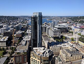
Downtown is the central business district of Seattle, Washington. It is fairly compact compared with other city centers on the U.S. West Coast due to its geographical situation, being hemmed in on the north and east by hills, on the west by Elliott Bay, and on the south by reclaimed land that was once tidal flats. It is bounded on the north by Denny Way, beyond which are Lower Queen Anne, Seattle Center, and South Lake Union; on the east by Interstate 5, beyond which is Capitol Hill to the northeast and Central District to the east; on the south by S Dearborn Street, beyond which is Sodo; and on the west by Elliott Bay, a part of Puget Sound.

Seward Park is a neighborhood in southeast Seattle, Washington just west of the park of the same name. It is part of Seattle's South End. The park occupies all of Bailey Peninsula.

Volunteer Park is a 48.3-acre (19.5 ha) park in the Capitol Hill neighborhood of Seattle, Washington, United States.
Seward Park is a municipal park in Seattle, Washington, United States. Located in the city neighborhood of the same name, it covers 300 acres. The park occupies all of Bailey Peninsula, a forested peninsula that juts into Lake Washington. It contains one of the last surviving tracts of old-growth forest within the city of Seattle. The park is named after U.S. Secretary of State William Seward.

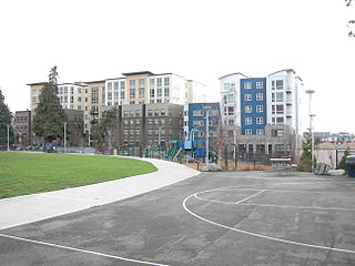
The Denny Triangle is a neighborhood in Seattle, Washington, United States, that stretches north of Downtown Seattle to the grounds of Seattle Center. Its generally flat terrain was originally a steep hill, taken down as part of a mammoth construction project in the first decades of the 20th century known as the Denny Regrade, which is another name for the neighborhood on the regraded area. The name Denny Triangle, referring to the northeastern portion of this regrading project, is a term that has gained currency as this neighborhood has seen increasing development in the first decades of the 21st Century.

Denny Blaine Park is a 2 acres (8,100 m2) water-front park in the Denny-Blaine neighborhood of Seattle, Washington. With picturesque views of Bellevue directly across the lake and Mount Rainier in the distance, it is primarily used for picnicking, sunbathing, and swimming. The park has also been one of Seattle's unofficial queer- and trans-friendly clothing optional beaches since the 1970s.

Denny Park is a park located in the South Lake Union neighborhood of Seattle, Washington. It occupies the block bounded by John Street and Denny Way on the north and south and Dexter and 9th Avenues N. on the west and east.
Cascade is an urban neighborhood abutting Downtown Seattle, Washington, United States, located adjacent to South Lake Union. It is bounded by: Fairview Avenue North on the west, beyond which is the rest of the Cascade Neighborhood; the Interstate 5 interchange for Mercer St to the north, beyond which is Eastlake; Interstate 5 on the east, beyond which is Capitol Hill; and Denny Way on the south, beyond which is Denny Triangle. It is surrounded by thoroughfares Mercer Street (eastbound), Fairview Avenue N. and Eastlake Avenue E., and Denny Way. The neighborhood, one of Seattle's oldest, originally extended much further: west to Terry Avenue, south to Denny Hill on the South, and east to Melrose Avenue E through the area now obliterated by Interstate 5. Some recent writers consider Cascade to omit the northern "arm", while others extend it westward to cover most of South Lake Union.
South Lake Union is a neighborhood in Seattle, Washington, so named because it is at the southern tip of Lake Union.

Cheshiahud and his family on Lake Union, Seattle, Washington in the 1880s are, along with Princess Angeline, among the few late-19th century Dkhw'Duw'Absh about whom a little is known. In the University of Washington (UW) Library image archives, he is called Chudups John or Lake Union John. His family were among the few of the Duwamish people who did not move from Seattle to the Port Madison Reservation or other reservations. They lived on Portage Bay, part of Lake Union, when a photo was taken around 1885. According to the Duwamish Tribe, Lake John had a cabin and potato patch at the foot of Shelby Street. A commemorative plaque of unknown reliability is said to exist at the eastern foot of Shelby. This land was given to him by Seattle pioneer David Denny or the property was purchased—see below. Photographer Orion O. Denny recorded Old Tom and Madeline, ca. 1904, further noted in the UW Library archives as Madeline and Old John, also known as Indian John or Cheshishon, who had a house on Portage Bay in the 1900s, south of what is now the UW campus although native people had been prohibited from residence in Seattle since the mid-1860s.

Reginald Heber Thomson was a self-taught American civil engineer. He worked in Washington state, mainly in Seattle, where he became city engineer in 1892 and held the position for two decades. Alan J. Stein wrote that Thomson "probably did more than any other individual to change the face of Seattle" and was responsible for "virtually all of Seattle's infrastructure".

Seattle Parks and Recreation is the government department responsible for maintaining the parks, open spaces, and community centers of the city of Seattle, Washington. The department maintains properties covering an area of over 6,200 acres (25 km2), which is equivalent to roughly 11% of the city's total area. Of those 6,200 acres (25 km2), 4,600 acres (19 km2) are developed.
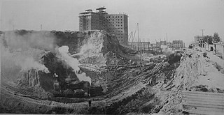
The topography of central Seattle was radically altered by a series of regrades in the city's first century of urban settlement, in what might have been the largest such alteration of urban terrain at the time.

David Thomas Denny was a member of the Denny Party, who are generally collectively credited as the founders of Seattle, Washington, United States. Though he ultimately underwent bankruptcy, he was a significant contributor to the shape of the city. Roger Sale, in his book Seattle, Past to Present, described him as having been "the pioneer to turn to if one had a plan that would be 'good for Seattle', and one needed a respectable tone and a willing investor."
Denny Way is an east–west arterial street in downtown Seattle, Washington, United States. It forms the northern end of the Belltown street grid as well as the boundaries of Belltown, Lower Queen Anne, South Lake Union, Denny Triangle, and Cascade. The street continues east through Capitol Hill to Madrona as a minor neighborhood street, ending near Madrona Park on Lake Washington.
Much of the content of this page is from "Seattle: Booms and Busts", by Emmett Shear; Shear has granted blanket permission for material from that paper to be reused in Wikipedia.