
Saint Paul is the capital of the U.S. state of Minnesota. It is the county seat of Ramsey County, the state's smallest in terms of area, second-most populous, and most densely populated county. As of 2020, its population was 311,527, making it the 63rd-largest city in the United States and the 11th-most populous in the Midwest. Most of the city lies east of the Mississippi River at the confluence with the Minnesota River. Minneapolis, the state's largest city, is across the river to the west. Together they are known as the "Twin Cities". They are the core of Minneapolis–Saint Paul metropolitan area, home to over 3.6 million and the third-largest in the Midwest.

Fort Snelling is a former military fortification and National Historic Landmark in the U.S. state of Minnesota on the bluffs overlooking the confluence of the Minnesota and Mississippi rivers. It is on the Dakota homeland of Bdóte with a history spanning thousands of years. The military site was initially named Fort Saint Anthony, but it was renamed Fort Snelling once its construction was completed in 1825.

St. Paul Downtown Airport, also known as Holman Field, is an airport just across the Mississippi River from downtown Saint Paul, Minnesota. It is one of several reliever airports in the Twin Cities operated by the Metropolitan Airports Commission. The airport has three runways and serves aircraft operated by corporations in the local area, a flight training school and the Minnesota Army National Guard aviation unit, as well as transient general aviation aircraft.

Bowman Field is a public airport five miles (8.0 km) southeast of downtown Louisville, in Jefferson County, Kentucky. The airport covers 426 acres (172 ha) and has two runways. The FAA calls it a reliever airport for nearby Louisville International Airport.

Fort Snelling State Park is a state park of the U.S. state of Minnesota, at the confluence of the Mississippi and Minnesota rivers. For many centuries, the area of the modern park has been of importance to the Mdewakanton Dakota people who consider it the center of the earth. The state park, which opened in 1962, is named for the historic Fort Snelling, which dates from 1820. The fort structure is maintained and operated by the Minnesota Historical Society. The bulk of the state park preserves the bottomland forest, rivers, and backwater lakes below the river bluffs. Both the state and historic fort structure are part of the Mississippi National River and Recreation Area, a National Park Service site.

Charles A. Lindbergh State Park is a 569-acre (2.3 km²) Minnesota state park on the outskirts of Little Falls. The park was once the farm of Congressman Charles August Lindbergh and his son Charles Lindbergh, the famous aviator. Their restored 1906 house and two other farm buildings are within the park boundaries. The house, a National Historic Landmark, and an adjacent museum are operated by the Minnesota Historical Society, known as the Charles Lindbergh House and Museum. Three buildings and three structures built by the Works Progress Administration in the 1930s were named to the National Register of Historic Places. These buildings include a picnic shelter and a water tower, built in the Rustic Style from local stone and logs, and have remained relatively unchanged since construction. Although the property includes shoreline on the Mississippi River, the Lindbergh family requested that the park not include intensive use areas for swimming or camping, so development was kept to a minimum.

Flandrau State Park is a state park of Minnesota, United States, on the Cottonwood River adjacent to the city of New Ulm. Initially called Cottonwood River State Park, it was renamed in 1945 to honor Charles Eugene Flandrau, a leading citizen of early Minnesota who commanded defenses during the Battles of New Ulm in the Dakota War of 1862. The park was originally developed in the 1930s as a job creation project to provide a recreational reservoir. However the dam was repeatedly damaged by floods and was removed in 1995.

Split Rock Creek State Park is a state park of Minnesota, USA, located in Ihlen, or just south of Pipestone.

The Intercity Bridge, more commonly known as the Ford Parkway Bridge, is a reinforced concrete arch bridge that spans the Mississippi River between Minneapolis, Minnesota and St. Paul, Minnesota, United States. It connects 46th Street in Minneapolis with Ford Parkway in Saint Paul. The bridge is historically significant as one of the largest reinforced concrete bridges ever built in Minnesota. It was built in 1925-1927 by James O. Heyworth, Inc. and was designed by Martin Sigvart Grytbak. The Intercity Bridge was listed on the National Register of Historic Places in 1989. It is notable as one of the monumental concrete rib-arch bridges spanning the high river bluffs along the Mississippi River, along with the Franklin Avenue Bridge, the Third Avenue Bridge, the 10th Avenue Bridge, and the Robert Street Bridge.

Plum Island Airport, in Newburyport, Massachusetts, is a privately owned, public-use airport owned by Historic New England and operated by Plum Island Aerodrome, Inc., a non-profit corporation. It has two runways, averages 54 flights per week, and has approximately 8 based aircraft.
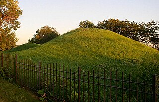
Indian Mounds Regional Park is a public park in Saint Paul, Minnesota, United States, featuring six prehistoric Native American burial mounds overlooking the Mississippi River. The oldest mounds were constructed 1,500–2,000 years ago by people of the Hopewell tradition. Later the Dakota people interred their dead there as well. At least 31 more mounds were destroyed by development in the late 19th century. They were the tallest Native American mounds in Minnesota or Wisconsin, and comprise one of the northwesternmost Hopewellian sites in North America. Indian Mounds Regional Park is a component of the Mississippi National River and Recreation Area, a unit of the National Park System. The Mounds Group is listed on the National Register of Historic Places. The 2014 nomination document provides a description of the archaeology and the context.

Fort Abercrombie, in North Dakota, was an American fort established by authority of an act of Congress, March 3, 1857. The act allocated twenty-five square miles of land on the Red River of the North in Dakota Territory to be used for a military outpost, but the exact location was left to the discretion of Lieutenant Colonel John J. Abercrombie. The fort was constructed in the year 1858. It was the first permanent military settlement in what became North Dakota, and is thus known as "The Gateway to the Dakotas".

The Stockyards Exchange is a building in South St. Paul, Minnesota, United States, built in 1887 by the recently formed Union Stock Yards Company of Omaha. The building housed businesses associated with the nearby stockyards, which later became the largest stockyards in the United States. It also housed a post office, city offices, and the city's first bank, Stockyards National Bank.
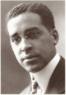
Clarence Wesley "Cap" Wigington (1883-1967) was an American architect who grew up in Omaha, Nebraska. After winning three first prizes in charcoal, pencil, and pen and ink at an art competition during the Trans-Mississippi Exposition in 1899, Wigington went on to become a renowned architect across the Midwestern United States, at a time when African-American architects were few. Wigington was the nation's first black municipal architect, serving 34 years as senior designer for the City of Saint Paul, Minnesota's architectural office when the city had an ambitious building program. Sixty of his buildings still stand in St. Paul, with several recognized on the National Register of Historic Places. Wigington's architectural legacy is one of the most significant bodies of work by an African-American architect.

The original Winnibigoshish Lake Dam was built 1881-1884, in order to regulate the flow of water on the Upper Mississippi River by the United States Army Corps of Engineers. A constant flow was desired by loggers, fur traders, and millers downstream at St. Anthony Falls. The dam crosses the county line between Cass County and Itasca County, and lies within the Leech Lake Indian Reservation in the U.S. state of Minnesota. It is located 208 miles (335 km) north of Saint Paul, and creates Lake Winnibigoshish, Minnesota's fifth largest lake, at 67,000 acres (270 km2).

This is a list of the National Register of Historic Places listings in Dakota County, Minnesota. It is intended to be a complete list of the properties and districts on the National Register of Historic Places in Dakota County, Minnesota, United States. Dakota County is located in the southeastern part of the U.S. state of Minnesota, bounded on the northeast side by the Upper Mississippi River and on the northwest by the Minnesota River. The locations of National Register properties and districts for which the latitude and longitude coordinates are included below, may be seen in an online map.

This list is of the properties and historic districts which are designated on the National Register of Historic Places or that were formerly so designated, in Hennepin County, Minnesota; there are 181 entries as of May 2021. A significant number of these properties are a result of the establishment of Fort Snelling, the development of water power at Saint Anthony Falls, and the thriving city of Minneapolis that developed around the falls. Many historic sites outside the Minneapolis city limits are associated with pioneers who established missions, farms, and schools in areas that are now suburbs in that metropolitan area.

This is a complete list of National Register of Historic Places listings in Ramsey County, Minnesota. It is intended to be a complete list of the properties and districts on the National Register of Historic Places in Ramsey County, Minnesota, United States. The locations of National Register properties and districts for which the latitude and longitude coordinates are included below, may be seen in an online map.

Saint Paul is the second largest city in the U.S. state of Minnesota, the county seat of Ramsey County, and the state capital of Minnesota. The origin and growth of the city was spurred by the proximity of Fort Snelling, the first major United States military presence in the area, and by its location on the Upper Mississippi River, with the northernmost natural navigable port on the mighty river.

The Riverside Hangar is a historic hangar complex at the St. Paul Downtown Airport in Saint Paul, Minnesota, United States. It comprises two parallel hangars with a connecting structure and some additions. Built on the bank of the Mississippi River in 1942, it was part of a bomber modification center that operated at the airport during World War II. The two hangar buildings were constructed with glued laminated timber arches, an innovation born of wartime steel shortages. Their important design features were their low cost and that they were erectable quickly by unskilled workers. Riverside Hangar was listed on the National Register of Historic Places for its state-level significance in the theme of engineering. It was nominated for being one of Minnesota's leading examples of glued laminated timber construction.


