Honduras, Cidra, Puerto Rico

Last updated
Honduras
Barrio
Honduras, Cidra, Puerto Rico locator map.png
Location of Honduras within the municipality of Cidra shown in red
Caribbean location map.svg
Red pog.svg
Honduras
Location of Puerto Rico
Coordinates: 18°09′07″N66°12′32″W / 18.152075°N 66.208831°W / 18.152075; -66.208831 [1]
Commonwealth Flag of Puerto Rico.svg  Puerto Rico
Municipality Bandera de Cidra, Puerto Rico.svg Cidra
Area
[1]
  Total2.22 sq mi (5.7 km2)
  Land2.22 sq mi (5.7 km2)
  Water0 sq mi (0 km2)
Elevation
[2]
1,863 ft (568 m)
Population
 (2010)
  Total1,705
  Density768/sq mi (297/km2)
 Source: 2010 Census
Time zone UTC−4 (AST)

Honduras is a barrio in the municipality of Cidra, Puerto Rico. Its population in 2010 was 1,705. [3] [4] [5]

Contents

History

Honduras was in Spain's gazetteers [6] until Puerto Rico was ceded by Spain in the aftermath of the Spanish–American War under the terms of the Treaty of Paris of 1898 and became an unincorporated territory of the United States. In 1899, the United States Department of War conducted a census of Puerto Rico finding that the combined population of Honduras and Toíta barrios was 800. [7]

Historical population
CensusPop.Note
1910 851
1920 8894.5%
1930 575−35.3%
1940 68318.8%
1950 652−4.5%
1960 6712.9%
1970 1,01951.9%
1980 1,35032.5%
1990 1,110−17.8%
2000 1,73856.6%
2010 1,705−1.9%
U.S. Decennial Census
1900 (N/A) [8] 1910-1930 [9]
1930-1950 [10] 1980-2000 [11] 2010 [12]

Sectors

Barrios (which are, in contemporary times, roughly comparable to minor civil divisions) [13] in turn are further subdivided into smaller local populated place areas/units called sectores (sectors in English). The types of sectores may vary, from normally sector to urbanización to reparto to barriada to residencial, among others. [14] [15] [16]

The following sectors are in Honduras barrio: [17]

Bernard, Caña, Díaz, El Malecón, Galindo, La Loma, Muñiz, Polo Torres, Puente Blanco, and San José.

See also

Related Research Articles

<span class="mw-page-title-main">Santa Rosa, Guaynabo, Puerto Rico</span> Barrio of Puerto Rico

Santa Rosa is a barrio in the municipality of Guaynabo, Puerto Rico. Its population in 2010 was 16,904.

<span class="mw-page-title-main">Cedro Abajo</span> Barrio of Naranjito, Puerto Rico

Cedro Abajo is a barrio in the municipality of Naranjito, Puerto Rico. Its population in 2010 was 4,627.

<span class="mw-page-title-main">Espino, Añasco, Puerto Rico</span> Barrio of Puerto Rico

Espino is a barrio in the municipality of Añasco, Puerto Rico. Its population in 2010 was 1407.

<span class="mw-page-title-main">Cuyón, Aibonito, Puerto Rico</span> Barrio of Puerto Rico

Cuyón is a barrio in the municipality of Aibonito, Puerto Rico. Its population in 2010 was 977.

<span class="mw-page-title-main">Cidra, Añasco, Puerto Rico</span> Barrio of Puerto Rico

Cidra is a barrio in the municipality of Añasco, Puerto Rico. Its population in 2010 was 326.

<span class="mw-page-title-main">Honduras, Barranquitas, Puerto Rico</span> Barrio of Puerto Rico

Honduras is a barrio in the municipality of Barranquitas, Puerto Rico. Its population in 2010 was 1,823.

<span class="mw-page-title-main">Carreras, Añasco, Puerto Rico</span> Barrio of Puerto Rico

Carreras is a barrio in the municipality of Añasco, Puerto Rico. Its population in 2010 was 3,780.

<span class="mw-page-title-main">Río Abajo, Cidra, Puerto Rico</span> Barrio of Puerto Rico

Río Abajo is a barrio in the municipality of Cidra, Puerto Rico. Its population in 2010 was 1,097.

<span class="mw-page-title-main">Cidra barrio-pueblo</span> Historical and administrative center (seat) of Cidra, Puerto Rico

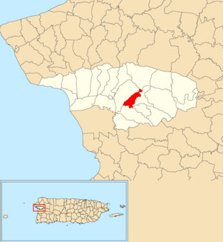
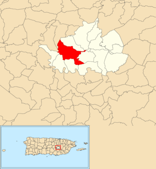
Cidra barrio-pueblo is a barrio and the administrative center (seat) of Cidra, a municipality of Puerto Rico. Its population in 2010 was 1,064.

<span class="mw-page-title-main">Monte Llano, Cidra, Puerto Rico</span> Barrio of Puerto Rico

Monte Llano is a barrio in the municipality of Cidra, Puerto Rico. Its population in 2010 was 984.

<span class="mw-page-title-main">Rincón, Cidra, Puerto Rico</span> Barrio of Puerto Rico

Rincón is a barrio in the municipality of Cidra, Puerto Rico. Its population in 2010 was 4,332.

<span class="mw-page-title-main">Salto, Cidra, Puerto Rico</span> Barrio of Puerto Rico

Salto is a barrio in the municipality of Cidra, Puerto Rico. Its population in 2010 was 176.

<span class="mw-page-title-main">Toíta, Cidra, Puerto Rico</span> Barrio of Puerto Rico

Toíta is a barrio in the municipality of Cidra, Puerto Rico. Its population in 2010 was 1,068.

<span class="mw-page-title-main">Arenas, Cidra, Puerto Rico</span> Barrio of Puerto Rico

Arenas is a barrio in the municipality of Cidra, Puerto Rico. Its population in 2010 was 6,123.

<span class="mw-page-title-main">Beatriz, Cidra, Puerto Rico</span> Barrio of Puerto Rico

Beatriz is a barrio in the municipality of Cidra, Puerto Rico. Its population in 2010 was 3,095.

<span class="mw-page-title-main">Ceiba, Cidra, Puerto Rico</span> Barrio in Cidra, Puerto Rico

Ceiba is a barrio in the municipality of Cidra, Puerto Rico. Its population in 2010 was 3,850.

<span class="mw-page-title-main">Bayamón, Cidra, Puerto Rico</span> Barrio of Puerto Rico

Bayamón is a barrio in the municipality of Cidra, Puerto Rico. Its population in 2010 was 5,995.

<span class="mw-page-title-main">Certenejas, Cidra, Puerto Rico</span> Barrio of Puerto Rico

Certenejas is a barrio in the municipality of Cidra, Puerto Rico. Its population in 2010 was 6,049. A newer barrio, it was formed from part of Bayamón barrio, also in Cidra.

<span class="mw-page-title-main">Rabanal, Cidra, Puerto Rico</span> Barrio of Puerto Rico

Rabanal is a barrio in the municipality of Cidra, Puerto Rico. Its population in 2010 was 4,228.

<span class="mw-page-title-main">Sud, Cidra, Puerto Rico</span> Barrio of Puerto Rico

Sud is a barrio in the municipality of Cidra, Puerto Rico. Its population in 2010 was 3,714.

References

  1. 1 2 "US Gazetteer 2019". US Census. US Government.
  2. U.S. Geological Survey Geographic Names Information System: Honduras barrio
  3. Picó, Rafael; Buitrago de Santiago, Zayda; Berrios, Hector H. Nueva geografía de Puerto Rico: física, económica, y social, por Rafael Picó. Con la colaboración de Zayda Buitrago de Santiago y Héctor H. Berrios. San Juan Editorial Universitaria, Universidad de Puerto Rico,1969.
  4. Gwillim Law (20 May 2015). Administrative Subdivisions of Countries: A Comprehensive World Reference, 1900 through 1998. McFarland. p. 300. ISBN   978-1-4766-0447-3 . Retrieved 25 December 2018.
  5. Puerto Rico: 2010 Population and Housing Unit Counts.pdf (PDF). U.S. Dept. of Commerce, Economics and Statistics Administration, U.S. Census Bureau. 2010.
  6. "Anuario del comercio, de la industria, de la magistratura y de la administración. 1881". Biblioteca Nacional de España (in Spanish). p. 1614. Retrieved 4 April 2023.
  7. Joseph Prentiss Sanger; Henry Gannett; Walter Francis Willcox (1900). Informe sobre el censo de Puerto Rico, 1899, United States. War Dept. Porto Rico Census Office (in Spanish). Imprenta del gobierno. p.  163.
  8. "Report of the Census of Porto Rico 1899". War Department Office Director Census of Porto Rico. Archived from the original on July 16, 2017. Retrieved September 21, 2017.
  9. "Table 3-Population of Municipalities: 1930 1920 and 1910" (PDF). United States Census Bureau. Archived (PDF) from the original on August 17, 2017. Retrieved September 21, 2017.
  10. "Table 4-Area and Population of Municipalities Urban and Rural: 1930 to 1950" (PDF). United States Census Bureau. Archived (PDF) from the original on August 30, 2015. Retrieved September 21, 2014.
  11. "Table 2 Population and Housing Units: 1960 to 2000" (PDF). United States Census Bureau. Archived (PDF) from the original on July 24, 2017. Retrieved September 21, 2017.
  12. Puerto Rico: 2010 Population and Housing Unit Counts.pdf (PDF). U.S. Dept. of Commerce Economics and Statistics Administration U.S. Census Bureau. 2010. Archived (PDF) from the original on 2017-02-20. Retrieved 2019-08-02.
  13. "US Census Barrio-Pueblo definition". factfinder.com. US Census. Archived from the original on 13 May 2017. Retrieved 5 January 2019.
  14. "Agencia: Oficina del Coordinador General para el Financiamiento Socioeconómico y la Autogestión (Proposed 2016 Budget)". Puerto Rico Budgets (in Spanish). Retrieved 28 June 2019.
  15. Rivera Quintero, Marcia (2014), El vuelo de la esperanza: Proyecto de las Comunidades Especiales Puerto Rico, 1997-2004 (first ed.), San Juan, Puerto Rico Fundación Sila M. Calderón, ISBN   978-0-9820806-1-0
  16. "Leyes del 2001". Lex Juris Puerto Rico (in Spanish). Retrieved 24 June 2020.
  17. "DESGLOSE DE SECTORES Y CENTROS DE VOTACIÓN PRECINTO ELECTORAL - CIDRA 076" (PDF). Comisión Estatal de Elecciones Puerto Rico (in Spanish). Retrieved 15 June 2020.