Hot Creek | |
---|---|
![]() Steam from geothermal springs rise above Hot Creek | |
Location | |
Country | United States |
State | California |
County | Mono |
Physical characteristics | |
Source | |
⁃ location | Twin Lakes |
⁃ coordinates | 37°37′05″N119°00′28″W / 37.61806°N 119.00778°W [1] |
⁃ elevation | 8,563 ft (2,610 m) |
Mouth | |
⁃ location | Owens River |
⁃ coordinates | 37°42′30″N118°47′01″W / 37.70833°N 118.78361°W Coordinates: 37°42′30″N118°47′01″W / 37.70833°N 118.78361°W [2] |
⁃ elevation | 6,844 ft (2,086 m) |
Hot Creek, starting as Mammoth Creek, is a stream in Mono County of eastern California, in the Western United States. It is within the Inyo National Forest.
A stream is a body of water with surface water flowing within the bed and banks of a channel. The stream encompasses surface and groundwater fluxes that respond to geological, geomorphological, hydrological and biotic controls.
Mono County (MOH-noh) is a county located in the east central portion of the U.S. state of California. As of the 2010 census, the population was 14,202. making it the fifth-least populous county in California. The county seat is Bridgeport. The county is located east of the Sierra Nevada between Yosemite National Park and Nevada.
California is a state in the Pacific Region of the United States. With 39.6 million residents across a total area of about 163,696 square miles (423,970 km2), California is the most populous U.S. state and the third-largest by area. The state capital is Sacramento. The Greater Los Angeles Area and the San Francisco Bay Area are the nation's second- and fifth-most populous urban regions, with 18.7 million and 9.7 million residents respectively. Los Angeles is California's most populous city, and the country's second-most populous, after New York City. California also has the nation's most populous county, Los Angeles County, and its largest county by area, San Bernardino County. The City and County of San Francisco is both the country's second-most densely populated major city after New York City and the fifth-most densely populated county, behind only four of the five New York City boroughs.
The creek begins its course in the eastern Sierra Nevada named as Mammoth Creek. It originates as an outflow of Twin Lakes, just south of Mammoth Mountain and above the town of Mammoth Lakes. The stream is primarily sourced from melted snow water at 8,500 feet (2,600 m) above sea level. It is quite cold, rarely being above 50 °F (10 °C).
The Sierra Nevada is a mountain range in the Western United States, between the Central Valley of California and the Great Basin. The vast majority of the range lies in the state of California, although the Carson Range spur lies primarily in Nevada. The Sierra Nevada is part of the American Cordillera, a chain of mountain ranges that consists of an almost continuous sequence of such ranges that form the western "backbone" of North America, Central America, South America and Antarctica.
Twin Lakes is a set of connected lakes at the base of the southeastern slope of Mammoth Mountain, in Mono County of eastern California. They are in the eastern Sierra Nevada, and within the Inyo National Forest.
Mammoth Mountain is a lava dome complex west of the town of Mammoth Lakes, California, in the Inyo National Forest of Madera and Mono Counties. It is home to a large ski area on the Mono County side.
As Mammoth Creek leaves the Sierra and flows east into the Long Valley Caldera it is joined by warmer water from geothermal springs at the Hot Creek State Fish Hatchery. From this confluence the stream is named Hot Creek, though its water temperature seldom exceeds 68 °F (20 °C) until it reaches Hot Creek Gorge, 8 miles (13 km) east of Mammoth Lakes. [3] In the Hot Creek Gorge, numerous hot springs near and in the stream bed add hot water into the stream. Its mouth is at the confluence with the Owens River upstream from Crowley Lake.
Long Valley Caldera is a depression in eastern California that is adjacent to Mammoth Mountain. The valley is one of the Earth's largest calderas, measuring about 20 miles (32 km) long (east-west), 11 miles (18 km) wide (north-south), and up to 3,000 feet (910 m) deep.
A hot spring is a spring produced by the emergence of geothermally heated groundwater that rises from the Earth's crust. While some of these springs contain water that is a safe temperature for bathing, others are so hot that immersion can result in injury or death.
A stream bed or streambed is the channel bottom of a stream or river, the physical confine of the normal water flow. The lateral confines or channel margins are known as the stream banks or river banks, during all but flood stage. Under certain conditions a river can branch from one stream bed to multiple stream beds. A flood occurs when a stream overflows its banks and flows onto its flood plain. As a general rule, the bed is the part of the channel up to the normal water line, and the banks are that part above the normal water line. However, because water flow varies, this differentiation is subject to local interpretation. Usually, the bed is kept clear of terrestrial vegetation, whereas the banks are subjected to water flow only during unusual or perhaps infrequent high water stages and therefore might support vegetation some or much of the time.
The springs near Hot Creek host one of the two known Tui chub populations of the endangered Owens tui chub species. [4]
The tui chub is a cyprinid fish native to western North America. Widespread in many areas, it is an important food source for other fish, including the cutthroat trout.
An endangered species is a species which has been categorized as very likely to become extinct in the near future. Endangered (EN), as categorized by the International Union for Conservation of Nature (IUCN) Red List, is the second most severe conservation status for wild populations in the IUCN's schema after Critically Endangered (CR). In 2012, the IUCN Red List featured 3,079 animal and 2,655 plant species as endangered (EN) worldwide. The figures for 1998 were 1,102 and 1,197 respectively. Many nations have laws that protect conservation-reliant species: for example, forbidding hunting, restricting land development or creating protected areas. Population numbers, trends and species' conservation status can be found at the lists of organisms by population.
The Owens tui chub was described in 1973 as a subspecies of tui chub endemic to the Owens River Basin in Eastern California, United States. The Owens tui chub is distinguished from its closest relative, the Lahontan tui chub, by scales with a weakly developed or absent basal shield, 13 to 29 lateral and apical radii, also by the structure of its pharyngeal arches, the number of anal fin rays, 10 to 14 gill rakers, and 52 to 58 lateral line scales. Dorsal and lateral coloration varies from bronze to dusky green, grading to silver or white on the belly. It may reach a total length of 30 centimetres (12 in). Owens tui chub are believed to be derived from Lahontan Basin tui chub that entered the Owens Basin from the north during the Pleistocene Epoch.
The Long Valley Observatory of the United States Geological Survey (USGS), a volcano observatory, monitors spring activity, water temperatures and chemistry, and stream flow, as well as the caldera volcanic activity. [3]
The United States Geological Survey is a scientific agency of the United States government. The scientists of the USGS study the landscape of the United States, its natural resources, and the natural hazards that threaten it. The organization has four major science disciplines, concerning biology, geography, geology, and hydrology. The USGS is a fact-finding research organization with no regulatory responsibility.
A volcano observatory is an institution that conducts research and monitoring of a volcano.
A caldera is a large cauldron-like hollow that forms shortly after the emptying of a magma chamber/reservoir in a volcanic eruption. When large volumes of magma are erupted over a short time, structural support for the rock above the magma chamber is lost. The ground surface then collapses downward into the emptied or partially emptied magma chamber, leaving a massive depression at the surface. Although sometimes described as a crater, the feature is actually a type of sinkhole, as it is formed through subsidence and collapse rather than an explosion or impact. Only seven caldera-forming collapses are known to have occurred since 1900, most recently at Bárðarbunga volcano, Iceland in 2014.
In hydrothermal systems, the circulation of ground water is driven by a combination of topography and geothermal heat sources. The system in the Long Valley Caldera is recharged primarily from snowmelt in the highlands around the western and southern rims of the caldera. The meltwater infiltrates to depths of a few kilometers (or miles), where some is heated to at least 430 °F (220 °C) by hot rock near the Inyo craters. The heated water, kept from boiling by high pressure, still has lower density than cold water, and it rises along steeply inclined fractures to depths of 0.3–1.25 miles (0.48–2.01 km). It then flows eastward through rock layers to hydrothermal vent discharge points at the surface along Hot Creek and around Crowley Lake. The water temperature declines eastward because of heat loss and mixing with cold water, and in the springs near Crowley Lake temperatures are at only about 125 °F (50 °C).
A hydrothermal vent is a fissure on the seafloor from which geothermally heated water issues. Hydrothermal vents are commonly found near volcanically active places, areas where tectonic plates are moving apart at spreading centers, ocean basins, and hotspots. Hydrothermal deposits are rocks and mineral ore deposits formed by the action of hydrothermal vents.
Crowley Lake is a reservoir on the upper Owens River in southern Mono County, California, in the United States. Crowley Lake is 15 miles south of Mammoth Lakes.
The springs in Hot Creek all emerge along a stream section between two faults and discharge a total of about 8.5 cubic feet per second (about 240 liters per second) of hot water. This water flow represents nearly 70 percent of the total heat discharged by all thermal springs in Long Valley Caldera. The thermal springs farther east all discharge less water and at lower temperatures. [3]
The larger and more vigorous springs discharge from fractures in the volcanic rock in the gorge. Rock fracturing happens because the thermal area lies within a region of frequent earthquakes and active uplift of the ground. When fractures become sealed by mineral deposition, spring discharge and temperature decline. When new fractures develop or sealed fractures reopen, spring discharge and temperatures can increase suddenly. [5]
The Hot Creek Gorge area of Hot Creek is managed by the U.S. Inyo National Forest as a geologic interpretive site and recreation area. It is popular for fishing, swimming, hiking, bird watching, and photography activities.
Hot Creek in the Hot Creek Gorge section can harbor dangers as the locations, discharge rates, and temperatures of springs often change. The changes can be sudden and dangerous to unprepared visitors (especially if entering beyond walkways and fences).
Since May 2006, springs in and near the most popular swimming areas have been geysering or intermittently spurting very hot, sediment-laden water as high as 6 feet (2 m) above the stream surface. At times this geysering activity is vigorous enough to produce "popping" sounds audible from hundreds of feet away. The geysering usually lasts a few seconds and occurs at irregular intervals, with several minutes between eruptions. Fumaroles, or steam vents, are in gorge area also. They can occur in the ground beyond the creek bed. The unpredictability of this hazardous spring activity led the U.S. Forest Service to close parts of the Hot Creek Gorge in June 2006, [6] and the closure has remained in effect as of February 2016. [7]
Hot Creek Gorge was a filming location in the 1969 film True Grit, as well as the 1960 film North to Alaska also starring John Wayne, the 1966 Steve McQueen film Nevada Smith, and the 1971 film Shoot Out with Gregory Peck, which also starred True Grit's Jeff Corey.
A geyser is a spring characterized by intermittent discharge of water ejected turbulently and accompanied by steam. As a fairly rare phenomenon, the formation of geysers is due to particular hydrogeological conditions that exist only in a few places on Earth. Generally all geyser field sites are located near active volcanic areas, and the geyser effect is due to the proximity of magma. Generally, surface water works its way down to an average depth of around 2,000 metres (6,600 ft) where it contacts hot rocks. The resultant boiling of the pressurized water results in the geyser effect of hot water and steam spraying out of the geyser's surface vent.
Yellowstone National Park is an American national park located in Wyoming, Montana, and Idaho. It was established by the U.S. Congress and signed into law by President Ulysses S. Grant on March 1, 1872. Yellowstone was the first national park in the U.S. and is also widely held to be the first national park in the world. The park is known for its wildlife and its many geothermal features, especially Old Faithful geyser, one of its most popular features. It has many types of ecosystems, but the subalpine forest is the most abundant. It is part of the South Central Rockies forests ecoregion.
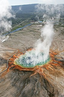
The geothermal areas of Yellowstone include several geyser basins in Yellowstone National Park as well as other geothermal features such as hot springs, mud pots, and fumaroles. The number of thermal features in Yellowstone is estimated at 10,000. A study that was completed in 2011 found that a total of 1,283 geysers have erupted in Yellowstone, 465 of which are active during an average year. These are distributed among nine geyser basins, with a few geysers found in smaller thermal areas throughout the Park. The number of geysers in each geyser basin are as follows: Upper Geyser Basin (410), Midway Geyser Basin (59), Lower Geyser Basin (283), Norris Geyser Basin (193), West Thumb Geyser Basin (84), Gibbon Geyser Basin (24), Lone Star Geyser Basin (21), Shoshone Geyser Basin (107), Heart Lake Geyser Basin (69), other areas (33). Although famous large geysers like Old Faithful are part of the total, most of Yellowstone's geysers are small, erupting to only a foot or two. The hydrothermal system that supplies the geysers with hot water sits within an ancient active caldera. Many of the thermal features in Yellowstone build up sinter, geyserite, or travertine deposits around and within them.
Mammoth Hot Springs is a large complex of hot springs on a hill of travertine in Yellowstone National Park adjacent to Fort Yellowstone and the Mammoth Hot Springs Historic District. It was created over thousands of years as hot water from the spring cooled and deposited calcium carbonate. Because of the huge amount of geothermal vents, travertine flourishes. Although these springs lie outside the caldera boundary, their energy has been attributed to the same magmatic system that fuels other Yellowstone geothermal areas.
A spring is a point at which water flows from an aquifer to the Earth's surface. It is a component of the hydrosphere.
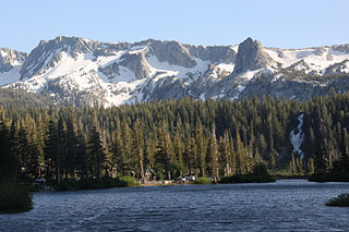
The Mono–Inyo Craters are a volcanic chain of craters, domes and lava flows in Mono County, Eastern California. The chain stretches 25 miles (40 km) from the northwest shore of Mono Lake to the south of Mammoth Mountain. The Mono Lake Volcanic Field forms the northernmost part of the chain and consists of two volcanic islands in the lake and one cinder cone volcano on its northwest shore. Most of the Mono Craters, which make up the bulk of the northern part of the Mono–Inyo chain, are phreatic volcanoes that have since been either plugged or over-topped by rhyolite domes and lava flows. The Inyo Craters form much of the southern part of the chain and consist of phreatic explosion pits, and rhyolitic lava flows and domes. The southernmost part of the chain consists of fumaroles and explosion pits on Mammoth Mountain and a set of cinder cones south of the mountain; the latter are called the Red Cones.
Lassen Volcanic National Park is an American national park in northeastern California. The dominant feature of the park is Lassen Peak, the largest plug dome volcano in the world and the southernmost volcano in the Cascade Range. Lassen Volcanic National Park started as two separate national monuments designated by President Theodore Roosevelt in 1907: Cinder Cone National Monument and Lassen Peak National Monument.
The geothermal areas in Lassen Volcanic National Park include several groups of hot springs and fumaroles, as remnants of former volcanic activity, exist in Lassen Volcanic National Park. Most of these lie in or are closely adjacent to Mount Tehama's caldera. Bumpass Hell is the most spectacular of these, but others of importance are Sulphur Works, Little Hot Springs Valley, Boiling Springs Lake and Devil's Kitchen. In each thermal area, the highest temperature of water generally is close to the boiling temperature at the altitude of the particular spring or fumarole — 198 °F (92 °C) at Bumpass Hell and 191 °F (88 °C) on the northwest flanks of Lassen Peak. Temperatures as high as 230 °F (110 °C) have been recorded in the park.
The Yellowstone Caldera is a volcanic caldera and supervolcano in Yellowstone National Park in the Western United States, sometimes referred to as the Yellowstone Supervolcano. The caldera and most of the park are located in the northwest corner of Wyoming. The major features of the caldera measure about 34 by 45 miles.
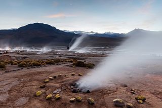
El Tatio is a geyser field located in the Andes Mountains of northern Chile at 4,320 metres (14,170 ft) above mean sea level. Various etymologies have been proposed for the name "El Tatio", which might mean "oven" or "grandfather". It is the third-largest geyser field in the world and the largest in the Southern Hemisphere.
The Owens River is a river in eastern California in the United States, approximately 183 miles (295 km) long. It drains into and through the Owens Valley, an arid basin between the eastern slope of the Sierra Nevada and the western faces of the Inyo and White Mountains. The river terminates at the endorheic Owens Lake south of Lone Pine, at the bottom of a 2,600 sq mi (6,700 km2) watershed.
The Bishop Tuff is a welded tuff that formed 767,100 ± 900 years ago as a rhyolitic pyroclastic flow during the eruption that created the Long Valley Caldera. Large outcrops of the tuff are located in Inyo and Mono Counties, California, United States.
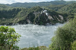
The Waimangu Volcanic Rift Valley is the hydrothermal system created on 10 June 1886 by the volcanic eruption of Mount Tarawera, on the North Island of New Zealand. It encompasses Lake Rotomahana, the site of the Pink and White Terraces, as well as the location of the Waimangu Geyser, which was active from 1900 to 1904. The area has been increasingly accessible as a tourist attraction and contains Frying Pan Lake, which is the largest hot spring in the world, and the steaming and usually pale blue Inferno Crater Lake, the largest geyser-like feature in the world although the geyser itself cannot be seen since it plays at the bottom of the lake.
Hydrothermal explosions occur when superheated water trapped below the surface of the earth rapidly converts from liquid to steam, violently disrupting the confining rock. Boiling water, steam, mud, and rock fragments called breccia are ejected over an area of a few meters up to several kilometers in diameter. Although the energy inherently comes from a deep igneous source, this energy is transferred to the surface by circulating meteoric water rather than by magma, as occurs in volcanic eruptions. The energy is stored as heat in hot water and rock within a few hundred feet of the surface.
Casa Diablo Hot Springs is a hot springs and active geothermal location, near Mammoth Lakes and the Eastern Sierra Nevada, in Mono County, eastern California.
The California Volcano Observatory (CalVO) is the volcano observatory that monitors the volcanic and geologic activity of California and Nevada. It is a part of the Volcano Hazards Program of the United States Geological Survey, a scientific agency of the United States government.