Hudson County Park System

Last updated

The Hudson County Park System owns and operates several county parks in Hudson County, New Jersey. It has its roots in the City Beautiful movement around the turn of the twentieth century. [1] The system comprises eight parks [2] [3] (the extension of one which includes a golf course) comprising 716.52 acres (290.0 ha). [4] Additionally, the county owns acreage in preservation areas in the New Jersey Meadowlands [5]

Contents

History

Flag of Hudson County, New Jersey Flag of Hudson County, New Jersey.gif
Flag of Hudson County, New Jersey

The City Beautiful movement at the turn of the twentieth century was conceived to revitalize industrialized urban communities and to provide them with public space for recreational activities. [6]

The concept of a county park system began in the 1880s. [7] The Hudson County Park Commission was created in 1892 to plan a park and boulevard system like those provided in other cities such as Boston and Newark. (There had been discussions of building a county long road as early as the 1870s. [8] ) The first feature the commission initiated was a boulevard that would connect the future parks called Hudson Boulevard (renamed John F. Kennedy Boulevard in the 1960s). It was constructed from 1892 to 1897, under Chief Engineer Edlow W. Harrison, in some places incorporating existing roads and became the county's principal north-south corridor. From Bayonne it wound north 14 miles to the Bergen County line. It was finished a few years later when it turned east in a loop and went south again as (Hudson) Boulevard East along the top edge of the Bergen Hill cliff to end at King's Bluff in Weehawken. In 1908 the State of New Jersey reconstructed the road to "improve and beautify it". [9]

In 1908, the Commission was sued by Philip Daab (Daab v. Hudson County Park Commission) due to a land dispute. [10]

The architects Daniel W. Langton and Charles N. Lowrie were active in the City Beautiful movement of architecture and were founding members of the American Society of Landscape Architects. Lowrie succeeded Langton as Landscape Architect for the Hudson County Park Commission, a position he held for thirty years. [6]

James J. Braddock—North Hudson Park

Woodcliff Lake 8.7.09BraddockParkByLuigiNovi18.jpg
Woodcliff Lake

The park is in North Hudson ( 40°47′58″N73°59′46″W / 40.7995°N 73.9962°W / 40.7995; -73.9962 ); the collection of municipalities in the northern part of the county; specifically the Woodcliff Section of North Bergen. [11] Its name refers to its location and to honor of James J. Braddock, World Heavy Weight Boxing Champion from 1935 to 1937 and inducted in hall of fame in 2001. [12] who was a lifelong resident of North Bergen. [13] It is also known colloquially as “80th Street Park” or “El Parque de La Ochenta”. It is roughly bounded by 79th Street to the south, Bergenline Avenue on the west, and Boulevard East to the east and north. The park was created in 1910 and encompasses an area of 167 acres (67.6 ha). [14] [15] [16] including Woodcliff Lake, the 16 acres (6.5 ha) body of water that is the largest lake in the county. [14] The North Hudson Park UFO sightings occurred on January 12, 1975. [17] The presence of a North Bergen temporary school building has led to controversy and referendums. [18]

Columbus Park

Columbus Park is near Hoboken High School on west side of Clinton Street between 9th and 10th Streets ( 40°44′53″N74°01′57″W / 40.74809°N 74.032439°W / 40.74809; -74.032439 ). [19] It is 2.6 acres [3] [20] Originally designed by Charles N. Lowrie, who was landscape architect for the Hudson County Parks Department. There is a statue of Christopher Columbus in the center of the park. There is also a memorial dedicated to John A. Sacci, a beloved high school history teacher, who was tragically shot on February 12, 1998. The monument was facilitated by students and to this day, the word "remembrance" is misspelled on the marble monument.

Stephen R. Gregg Park—Bayonne Park

Stephen R. Gregg Park ( 40°39′45″N74°06′37″W / 40.662411°N 74.110228°W / 40.662411; -74.110228 ), also known as Bayonne Park, is located west of Kennedy Boulevard on Newark Bay in Bayonne. Comprising 97.5 acres, [3] it was originally designed by Charles N. Lowrie, landscape architect for the Hudson County Parks Department. Named for Stephen Raymond Gregg Sr. (September 1, 1914 February 4, 2005), a Bayonne native and United States Army soldier who received the United States military's highest decoration—the Medal of Honor—for his actions in World War II. [21] A statue of Gregg in the park was unveiled in 2021 [22] It is a component of the Hackensack RiverWalk. In June 2022 landascaped gardens were dedicated to the memory of Bayonne residents who had died of Covid-19. [23]

Laurel Hill

Laurel Hill ( 40°45′33″N74°05′13″W / 40.759204°N 74.086819°W / 40.759204; -74.086819 ), better known as Snake Hill, is the newest county park, along the Hackensack River southwest of Secaucus Junction in Secaucus and is part of the New Jersey Meadowlands. Visible from the eastern spur of the New Jersey Turnpike, the rock rises 150 feet (46 m) from the surrounding Meadowlands. [24] It comprises 104.5 acres with potential 100 adjacent acres for expansion. [3]

Lincoln Park

Lincoln Park ( 40°43′29″N74°04′51″W / 40.724640°N 74.080939°W / 40.724640; -74.080939 ), started in 1905, is in the Bergen Section of Jersey City, New Jersey. The eastern part of the park has an area of 150.4 acres (60.9 ha). [25] Its main entrance is adorned with Lincoln the Mystic.

Lincoln Park West—Skyway Golf Course

Skyway from Lincoln Park Pulaski Skyway fr Lincoln Pk jeh.JPG
Skyway from Lincoln Park

Lincoln Park West comprises 123 acres. [3] The Skyway Golf Course is the only public golf facility in the county. [26] The nine-hole course is along the Hackensack River west of U.S. Route 1/9 Truck between Communipaw and Duncan Avenues. The 55 acres (22.3 ha) course was created on a larger site and raised the about 1.2 million cubic yards of soil to an average 25 feet with hills as high as 45 feet. [27] [28] It opened in June 2015. [29] Its name is inspired by the Pulaski Skyway.

Mercer Park

Mercer Park ( 40°41′21″N74°05′44″W / 40.689028°N 74.095556°W / 40.689028; -74.095556 ) was created from the remnants of Curries Woods at the border of Greenville, Jersey City and Bayonne north of the National Docks Secondary rail line. It was named after General Hugh Mercer, a famous American Revolution figure. It was developed during the Works Progress Administration (WPA) era under the New Deal. [30] The park lost much of its land to the city's largest housing authority project in 1959, except a small tract in Bayonne [31] of 6.4 acres. [3]

Washington Park Washington-park-nj-arch.jpg
Washington Park

Washington Park

Washington Park ( 40°45′10″N74°02′41″W / 40.752811°N 74.044714°W / 40.752811; -74.044714 ) straddles Jersey City Heights and Union City along their border on Paterson Plank Road. It comprises 21 acres (8.5 ha) west of Palisade Avenue. Into the 1900s the land was owned by the Stuckleys, a wealthy New York family who operated it as carnival or campground and held fairs, circuses, and Wild West shows. [32] Much of the park was laid-out during the Works Progress Administration in the 1930s. [33]

West Hudson Park

West Hudson Park Davis Av West Hudson Park jeh.jpg
West Hudson Park

West Hudson Park ( 40°45′35″N74°08′43″W / 40.7597°N 74.1454°W / 40.7597; -74.1454 ) is located in the West Hudson communities of Harrison and Kearny. [34] [35] It was originally designed by Charles N. Lowrie. It comprises 43.4 acres. [3] [36]

See also

Related Research Articles

<span class="mw-page-title-main">Hudson County, New Jersey</span> County in New Jersey, United States

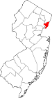
Hudson County is the smallest and most densely populated county in the U.S. state of New Jersey. It lies west of the lower Hudson River, which was named for Henry Hudson, the sea captain who explored the area in 1609. Part of New Jersey's Gateway Region in the New York metropolitan area, the county seat is Jersey City, which is the county's largest city in terms of both population and area. The county is part of the North Jersey region of the state.

<span class="mw-page-title-main">North Bergen, New Jersey</span> Township in Hudson County, New Jersey, United States

North Bergen is a township in the northern part of Hudson County, in the U.S. state of New Jersey. As of the 2020 United States census, the township's population was 63,361, an increase of 2,588 (+4.3%) from the 2010 census count of 60,773, which in turn reflected an increase of 2,681 (+4.6%) from the 58,092 counted in the 2000 census. The township was incorporated in 1843. It was much diminished in territory by a series of secessions. Situated on the Hudson Palisades, it is one of the hilliest municipalities in the United States. Like neighboring North Hudson communities, North Bergen is among those places in the nation with the highest population density and a majority Hispanic population.

Bergen Township was a township that existed in the U.S. state of New Jersey, from 1661 to 1862, first as Bergen, New Netherland, then as part Bergen County, and later as part of Hudson County. Several places still bear the name: the township of North Bergen; Bergen Square, Old Bergen Road, Bergen Avenue, Bergen Junction, Bergen Hill and Bergen Arches in Jersey City; Bergen Point in Bayonne; and Bergenline Avenue and Bergen Turnpike in North Hudson.

<span class="mw-page-title-main">County Route 501 (New Jersey)</span> Highway in New Jersey

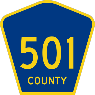
County Route 501 is a county highway in New Jersey in two segments spanning Middlesex, Hudson, and Bergen counties. The southern section runs from South Plainfield to Perth Amboy, the northern section runs from Bayonne to Rockleigh, and the two sections are connected by New York State Route 440 across Staten Island.

The Newark Plank Road was a major artery between Hudson Waterfront at Paulus Hook and city of Newark further inland across the New Jersey Meadows. As its name suggests, a plank road was constructed of wooden planks laid side-to-side on a roadbed. Similar roads, the Bergen Point Plank Road, the Hackensack Plank Road and Paterson Plank Road, traveled to the locales for which they are named. The name is no longer used, the route having been absorbed into other streets and freeways.

<span class="mw-page-title-main">Hackensack Plank Road</span>

The Hackensack Plank Road, also known as Bergen Turnpike, was a major artery which connected the cities of Hoboken and Hackensack, New Jersey. Like its cousin routes, the Newark Plank Road and Paterson Plank Road, it travelled over Bergen Hill and across the Hackensack Meadows from the Hudson River waterfront to the city for which it was named. It was originally built as a colonial turnpike road as Hackensack and Hoboken Turnpike. The route mostly still exists today, though some segments are now called the Bergen Turnpike. It was during the 19th century that plank roads were developed, often by private companies which charged a toll. As the name suggests, wooden boards were laid on a roadbed in order to prevent horse-drawn carriages and wagons from sinking into softer ground on the portions of the road that passed through wetlands. The company that built the road received its charter on November 30, 1802. The road followed the route road from Hackensack to Communipaw that was described in 1679 as a "fine broad wagon-road."

<span class="mw-page-title-main">Bayfront, Jersey City</span> Populated place in Hudson County, New Jersey, US

Bayfront is an urban redevelopment project in Jersey City, New Jersey.

<span class="mw-page-title-main">Bergen Hill</span> Lower part of the Hudson Palisades, New Jersey, United States

Bergen Hill refers to the lower Hudson Palisades in New Jersey, where they emerge on Bergen Neck, which in turn is the peninsula between the Hackensack and Hudson Rivers, and their bays. In Hudson County, it reaches a height of 260 feet.

<span class="mw-page-title-main">Hudson River Waterfront Walkway</span> Park in the United States of America

The Hudson River Waterfront Walkway, also known as the Hudson River Walkway, is a promenade along the Hudson Waterfront in New Jersey. The ongoing and incomplete project located on Kill van Kull and the western shore of Upper New York Bay and the Hudson River was implemented as part of a New Jersey state-mandated master plan to connect the municipalities from the Bayonne Bridge to the George Washington Bridge with an urban linear park and provide contiguous unhindered access to the water's edge.

<span class="mw-page-title-main">Hackensack River Greenway</span> Trail along the lower Hackensack River

Hackensack River Greenway, once known as the Hackensack RiverWalk, a is partially constructed greenway along the Newark Bay and Hackensack River in Hudson County, New Jersey, United States.

<span class="mw-page-title-main">North Hudson, New Jersey</span> Populated place in Hudson County, New Jersey, US

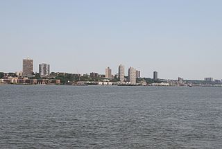
North Hudson is the area in the northern part of Hudson County, New Jersey, situated on the west bank of the Hudson River, mostly atop the Hudson Palisades. It comprises Weehawken, Union City, West New York, Guttenberg, and North Bergen.

<span class="mw-page-title-main">Bergen Neck</span> Peninsula in northeastern New Jersey, United States

Bergen Neck is a peninsula in the United States, located between the Upper New York Bay and the Newark Bay in the Hudson County, New Jersey municipalities of Bayonne and Jersey City. Its southernmost tip, Bergen Point, is separated from Staten Island by the Kill van Kull, which is crossed by the Bayonne Bridge.

Curries Woods is a neighborhood in the southern part of Greenville in Jersey City, New Jersey bordering Bayonne. It was named after James Curie, who was on the town Committee for Greenville when it was its own Township in the 19th century. The area remained rural until the later part of the century when the Central Railroad of New Jersey built a line connecting ferries to Elizabeth, New Jersey and New York City. Currie's Woods still remained untouched through the late part of the century and it was valued for its woods, rocky shore and dunes on Newark Bay. A lot of the land was eventually lost, but a tract was set aside in the early part of the 20th century. A small cemetery, the Old Greenville Cemetery, was nearby. This park lost much of its land to the city's largest Housing Authority project in 1959, except a small tract in Bayonne, Mercer Park.

Bergen-Lafayette is a section of Jersey City, New Jersey.

<span class="mw-page-title-main">West Side, Jersey City</span> Populated place in Hudson County, New Jersey, US

The West Side of Jersey City is an area made up of several diverse neighborhoods on either side of West Side Avenue, one of the city's main shopping streets. Parallel and west of Kennedy Boulevard, West Side Avenue carries two county route designations.

<span class="mw-page-title-main">Hudson Waterfront</span> Place in Hudson and Bergen

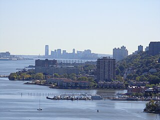
The Hudson Waterfront is an urban area of northeastern New Jersey along the lower reaches of the Hudson River, the Upper New York Bay and the Kill van Kull. Though the term can specifically mean the shoreline, it is often used to mean the contiguous urban area between the Bayonne Bridge and the George Washington Bridge that is approximately 19 miles (31 km) long. Historically, the region has been known as Bergen Neck, the lower peninsula, and Bergen Hill, lower Hudson Palisades. It has sometimes been called the Gold Coast.

<span class="mw-page-title-main">Bergenwood, North Bergen</span> Populated place in Hudson County, New Jersey, US

Bergenwood is a long narrow district of North Bergen, New Jersey in the northern central part of the township between Kennedy Boulevard and Tonnelle Avenue, characterized by the steep slopes on the west side of the Hudson Palisades as they descend to the New Jersey Meadowlands.

<span class="mw-page-title-main">Central Avenue (Hudson Palisades)</span> Populated place in Hudson County, New Jersey, US

Central Avenue is a 12-block-long thoroughfare in the Heights neighborhood of Jersey City, New Jersey, United States. One of 13 shopping districts in the city, it is designated County Route 663 for 1.60-mile (2.57 km) of its length. It originates at the intersection of Summit Avenue and Pavonia Avenue, and runs north, intersecting Newark Avenue one block east of Five Corners to Paterson Plank Road near Transfer Station. The avenue continues north through Union City without the county route designation to 35th Street, two blocks north of Hackensack Plank Road.

<span class="mw-page-title-main">Lincoln Park (Jersey City)</span>

Lincoln Park is an urban park in Jersey City, New Jersey with an area of 273.4 acres (110.6 ha). Part of the Hudson County Park System, it opened in 1905 and was originally known as West Side Park. The park was designed by Daniel W. Langton and Charles N. Lowrie, both founding members of the American Society of Landscape Architects.

<span class="mw-page-title-main">Bergen Section, Jersey City</span> Populated place in Hudson County, New Jersey, US

The Bergen Section of Jersey City, New Jersey is the neighborhood on either side of Kennedy Boulevard between Saint Peter's College/ McGinley Square and Communipaw Avenue in the Bergen-Lafayette section of the city. The name Bergen, used throughout Hudson County, is taken from the original Bergen, New Netherland settlement at Bergen Square.

References

  1. Muirheid, Walter G. (1 March 1910). "The Park System of Hudson County, New Jersey, The Park System of Hudson County, New Jersey". The Annals of the American Academy of Political and Social Science. 35 (2): 57–63. doi:10.1177/000271621003500208. S2CID   141076717.
  2. "A Path Through Hudson County, New Jersey Parks". Myhudsoncounty.com. 20 October 2012. Retrieved 29 June 2018.
  3. 1 2 3 4 5 6 7 "Hudson County Park Master Plan". Hudson County. November 1998. Retrieved 21 July 2018.
  4. Open Space Resources (PDF) (Report). Hudson County. Retrieved 30 October 2023.
  5. "MESIC Report".
  6. 1 2 "Lincoln Park". Archived from the original on 2016-02-17. Retrieved 2018-07-13.
  7. "Hudson County Is Awake; Vast Improvements Are Under Way And In Prospect. Evidences Of A Realization That She Has Not Kept Up With The Procession -- Parks, A Fine Driveway, And Rapid Transit" (PDF). The New York Times. March 29, 1891.
  8. "The old and the New - The Opposition and the Proposed Route" (PDF). The New York Times. August 12, 1873. Retrieved March 29, 2010.
  9. A. G. Lichtenstein & Associates, Inc. for NJDOT and FHWA (2001). "Historic Bridge Survey (1991–1994)". New Jersey Department of Transportation. Retrieved 3 July 2018.
  10. The Atlantic Reporter. Vol. 71–72. West Publishing Company. 1909. p. 51.
  11. https://www.nj.gov/dep/greenacres/pdf/NBergen_Full_Appendix.pdf [ bare URL PDF ]
  12. "JAMES J. BRADDOCK PARK TO INSTALL HUGE SHAW SPORTS TURF FIELD - Shaw Sports Turf". Archived from the original on 2018-07-14. Retrieved 2018-07-14.
  13. "James J. Braddock North Hudson Park". Vegahasclass.wordpress.com. 12 December 2014.
  14. 1 2 "North Bergen's famous lake is receiving a makeover". Eu.northjersey.com.
  15. "Hudson County Maps Huge Park Project". The New York Times. 5 October 1975.
  16. "UFOs piranhas trains and odd ducks Two hours in the life of North Hudson Braddock Park - James J. Braddock Park in North Bergen has seen some unusual occurrences since it was established in 1910 – from a famous UFO sighting in 1975 to people findi." Hudsonreporter.com. Retrieved 14 July 2018.
  17. "Want to see a UFO? Try North Bergen". Nj.com. 29 February 2012.
  18. "Last chance to save Braddock Park". 24 July 2020.
  19. "Columbus Park - Formerly Hudson County Park, Hoboken. Covers the block from Ninth to Tenth Streets and Willow to beyond Clinton St. which is interrupted by the park. Once commonly called Tenth Street Park on maps and in publications". Hoboken.pastperfectonline.com. Retrieved 14 July 2018.
  20. "Archived copy" (PDF). Archived from the original (PDF) on 2016-12-23. Retrieved 2018-07-14.{{cite web}}: CS1 maint: archived copy as title (link)
  21. "Bayonne pond work part of Hudson's $1.7M parks upgrades". Nj.com. 17 July 2017. Retrieved 29 June 2018.
  22. "Hudson County unveils World Ward II hero's statue at park that bears his name in Bayonne - Hudson County View". 16 July 2021.
  23. "Gardens in Bayonne county park officially honor Cherie la Pelusa". 17 June 2022.
  24. Laurel Hill Park, Secaucus, Hudson County, New Jersey. Accessed July 15, 2018.
  25. "Lincoln Park". Njcu.edu. Archived from the original on 17 February 2016. Retrieved 29 June 2018.
  26. "The Skyway Golf Course at Lincoln Park West – Golf Jersey City, NJ". Skywaygolfcourse.com. Retrieved 29 June 2018.
  27. "Not rich? Hudson County building affordable public golf course in Jersey City". Nj.com. 6 October 2014. Retrieved 29 June 2018.
  28. "Construction of new nine-hole course in Jersey City close to completion". Golfcoursearchitecture.net. Retrieved 29 June 2018.
  29. Heinis, John (12 June 2015). "Hudson County officials gather in Jersey City for public golf course ribbon cutting - Hudson County View". Hudsoncountyview.com. Retrieved 29 June 2018.
  30. "Mercer Park Improvements - Bayonne NJ".
  31. Curries Woods Archived 2009-01-10 at the Wayback Machine
  32. Gittleman, Nicole (January 10, 2023). "A Historical Walking Tour of Jersey City Heights". The Hoboken Girl. Archived from the original on January 11, 2023. Retrieved January 19, 2023.
  33. "Washington Park". Jersey City Past and Present. New Jersey City University . Retrieved 28 October 2023.
  34. Krasner, Barbara (2000). Kearny. Arcadia. ISBN   9780738504032.
  35. "West Hudson Park field slated for makeover – The Observer Online". 10 May 2017.
  36. Lucadamo, Kathleen (27 May 2016). "Harrison, N.J., Is Back on the Radar - WSJ". Wall Street Journal.