
Hudson Bay, sometimes called Hudson's Bay, is a large body of saltwater in northeastern Canada with a surface area of 1,230,000 km2 (470,000 sq mi). It is located north of Ontario, west of Quebec, north east of Manitoba and south east of Nunavut, but politically entirely part of Nunavut. Although not geographically apparent, it is for climatic reasons considered to be a marginal sea of the Arctic Ocean. It drains a very large area, about 3,861,400 km2 (1,490,900 sq mi), that includes parts of southeastern Nunavut, Alberta, Saskatchewan, Ontario, Quebec, all of Manitoba, and parts of the U.S. states of North Dakota, South Dakota, Minnesota, and Montana. Hudson Bay's southern arm is called James Bay.

James Bay is a large body of water located on the southern end of Hudson Bay in Canada. Both bodies of water extend from the Arctic Ocean, of which James Bay is the southernmost part. It borders the Canadian provinces of Quebec and Ontario. Islands within the bay, the largest of which is Akimiski Island, are part of Nunavut.
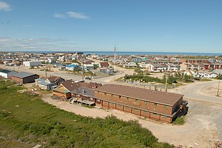
Churchill is a town in northern Manitoba, Canada, on the west shore of Hudson Bay, roughly 140 km (87 mi) from the Manitoba–Nunavut border. It is most famous for the many polar bears that move toward the shore from inland in the autumn, leading to the nickname "Polar Bear Capital of the World" that has helped its growing tourism industry.

Akimiski Island is the largest island in James Bay, Canada, which is part of the Qikiqtaaluk Region of the territory of Nunavut. It has an area of 3,001 km2 (1,159 sq mi), making it the 163rd largest island in the world, and Canada's 29th largest island. Akimiski Island is 19 km (12 mi) from the province of Ontario. From the western side of the island, the Ontario coastline is visible.

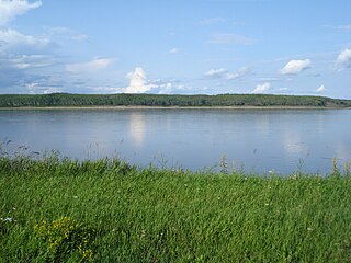
The Moose River is a river in the Hudson Plains ecozone of northern Ontario, Canada. The river flows 100 km northeast from the confluence of the Mattagami and Missinaibi Rivers into James Bay. Its drainage basin is 108,500 square kilometres (41,900 sq mi) and it has a mean discharge rate of 1,370 cubic metres (48,000 cu ft). Its full length is 547 kilometres (340 mi) if counted from the head of the Mattagami River.

The Boreal Shield Ecozone, as defined by the Commission for Environmental Cooperation (CEC), is the largest ecozone in Canada. Covering 1.8 million square kilometres it covers almost 20% of Canada's landmass, stretching from northern Saskatchewan to Newfoundland.
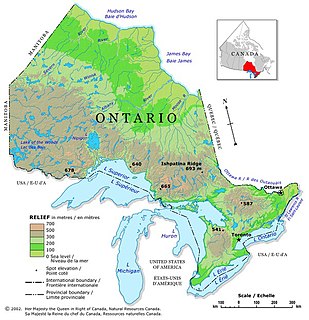
Ontario is located in East/Central Canada. It is Canada's second largest province in total land area. Its physical features vary greatly from the Mixedwood Plains in the southeast to the boreal forests and tundra in the north. Ontario borders Manitoba to the west, Hudson Bay and James Bay to the north, Quebec to the east, and the Great Lakes and the United States to the south. The province is named for Great Lake Ontario, an adaptation of the Iroquois word Onitariio, meaning "beautiful lake", or Kanadario, variously translated as "beautiful water". There are approximately 250,000 lakes and over 100,000 kilometres (62,000 mi) of rivers in the province.

The geography of Manitoba addresses the easternmost of the three prairie Canadian provinces, located in the longitudinal centre of Canada. Manitoba borders on Saskatchewan to the west, Ontario to the east, Nunavut to the north, and the American states of North Dakota and Minnesota to the south. Although the border with Saskatchewan appears straight on large-scale maps, it actually has many right-angle corners that give the appearance of a slanted line. In elevation, Manitoba ranges from sea level on Hudson Bay to 2727 ft (831 m) on top of Baldy Mountain. The northern sixty percent of the province is on the Canadian Shield. The northernmost regions of Manitoba lie permafrost, and a section of tundra bordering Hudson Bay.

The Arctic Cordillera is a terrestrial ecozone in northern Canada characterized by a vast, deeply dissected chain of mountain ranges extending along the northeastern flank of the Canadian Arctic Archipelago from Ellesmere Island to the northeasternmost part of the Labrador Peninsula in northern Labrador and northern Quebec, Canada. It spans most of the eastern coast of Nunavut with high glaciated peaks rising through ice fields and some of Canada's largest ice caps, including the Penny Ice Cap on Baffin Island. It is bounded to the east by Baffin Bay, Davis Strait and the Labrador Sea while its northern portion is bounded by the Arctic Ocean.

The Hudson Bay Lowlands is a vast wetland located between the Canadian Shield and southern shores of Hudson Bay and James Bay. Most of the area lies within the province of Ontario, with smaller portions reaching into Manitoba and Quebec. Many wide and slow-moving rivers flow through this area toward the saltwater of Hudson Bay: these include the Churchill, Nelson and Hayes in Manitoba, Severn, Fawn, Winisk, Asheweig, Ekwan, Attawapiskat, and Albany in Ontario, and the Harricana, Rupert and Eastmain in Quebec. This is the largest wetland in Canada, and one of the largest in the world. The region can be subdivided into three bands running roughly northwest to southeast: the Coastal Hudson Bay Lowland, Hudson Bay Lowland, and James Bay Lowland.
Southern James Bay is a coastal wetland complex in northeastern Ontario, Canada bordering James Bay and Quebec. It was designated as a wetland of international importance via the Ramsar Convention on May 27, 1987. The shallow waters of the James Bay region represent an important late autumn staging area for migratory, Arctic-breeding waterbirds.

The Arctic Archipelago Marine Ecozone, as defined by the Commission for Environmental Cooperation (CEC), is a marine ecozone in the Canadian Arctic, encompassing Hudson Bay, James Bay, the internal waters and some shores of the islands in the Canadian Arctic Archipelago, and the shores of the territories, northern Ontario and western Quebec. Early exploration of these waters by Europeans were conducted to find a passage to the Orient, now referred to as the Northwest Passage.

The Taiga Shield Ecozone, as defined by the Commission for Environmental Cooperation (CEC), is an ecozone which stretches across Canada's subarctic region. Some regions exhibit exposed Precambrian bedrock of the Canadian Shield, the oldest of the world's geological formations. The world's oldest rocks, dating to four billion years, are found in the Canadian Shield north of Great Slave Lake.
The Taiga Plain Ecozone, as defined by the Commission for Environmental Cooperation (CEC), is a Canadian terrestrial ecozone that covers most of the western Northwest Territories, extending to northwest Alberta, northeast British Columbia and slightly overlapping northeastern Yukon.

The Southern Arctic Ecozone, as defined by the Commission for Environmental Cooperation (CEC), is a Canadian terrestrial ecozone which spans the northern coast of mainland Northwest Territories, most of northern mainland Nunavut excepting the northeast peninsula, and a portion of northwestern Quebec. Its two constituent territories are interrupted by Hudson Bay. The ecozone can also be described as including the northernmost part of the Interior Plains of Western Canada and parts of the Canadian Shield located on both sides of northern Hudson Bay.

The wildlife of Canada or biodiversity of Canada consist of over 80,000 classified species, with an equal number thought yet to be recognized. Known fauna and flora have been identified from five different kingdoms: protozoa ; chromist ; fungis ; plants ; and animals. Insects account for nearly 70 percent of recorded animal species in Canada.

The Hudson Plains Ecoregion is a vast, flat, and waterlogged landscape. This ecoregion covers a 369,000 square kilometer area along the south shoreline of the Hudson Bay, which includes the Canadian provinces of Eastern Quebec, Northern Ontario and Western Manitoba. Because of the location of the ecoregion, winter prevails for many months of the year and rising temperatures, along with melting ice, makes fog common. The short summers provide a home for thousands of migrating birds. The region is used by humans for its mineral resources and hydroelectric power as a result of the abundance of water and emergent societal needs. Though relatively uninhabited and undisturbed, the natural resources of the Hudson Plains are still subject to anthropogenic activities. Its climatic, geographic, and evolutionary patterns categorize it as one of many ecoregions in North America.

The Canadian Arctic tundra is a biogeographic designation for Northern Canada's terrain generally lying north of the tree line or boreal forest, that corresponds with the Scandinavian Alpine tundra to the east and the Siberian Arctic tundra to the west inside the circumpolar tundra belt of the Northern Hemisphere.

The Low Arctic tundra ecoregion covers a rolling landscape of shrubby tundra vegetation along the northern edge of mainland Canada along the border of the Northwest Territories and Nunavut, and a small portion in Quebec on the northeast coast of Hudson Bay. The region is important for large herds of caribou and other large mammals, and for large nesting colonies of birds such as snow geese. The region is mostly intact, with 95% remaining intact.
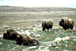
The Middle Arctic tundra ecoregion covers a broad stretch of northern Canada - the southern islands of the Arctic Archipelago, plus the northern mainland of Nunavut and, across Hudson Bay to the east, a portion of northern Quebec. This is the coldest and driest ecoregion in Canada, and can be referred to as a 'polar desert'. It is an important region for breeding and migratory birds, and supports 80% of the world's muskox.
