Hundred of Brixton

Last updated

Brixton
Brixton Hundred.jpg
Brixton Hundred from an engraving by Eman Bowen, c.1760
Area
  183130,400 acres (123 km2)
  188729,714 acres (120 km2)
Population
  1861409,504
  1887825,155
History
  Createdin antiquity
  Abolished1889
  Succeeded byvarious, see text
Status hundred
   HQ Brixton
Subdivisions
  Type Parishes
  Units
  • Barnes
  • Battersea
  • Bermondsey
  • Camberwell
  • Clapham
  • Hatcham
  • Lambeth
  • Merton
  • Mortlake
  • Newington
  • Penge
  • Putney
  • Rotherhithe
  • Southwark Christchurch
  • Southwark St George
  • Southwark St John
  • Southwark St Margaret
  • Southwark St Mary
  • Southwark St Olave
  • Southwark St Saviour
  • Southwark St Thomas
  • Streatham
  • Tooting Graveney
  • Wandsworth
  • Wimbledon

Brixton Hundred or the Hundred of Brixton was for many centuries a group of parishes (hundred) used for meetings and taxation of their respective great estates in the north east of the county of Surrey, England. Its area has been entirely absorbed by the growth of London; with its name currently referring to the Brixton district. [1] Its area corresponds to London Boroughs: Southwark, Lambeth, Wandsworth and parts of Lewisham, Merton and Richmond upon Thames.

Contents

History

Toponymy

The name is first recorded as Brixiges stan in 1062, meaning stone of Beorhtsige. [1] His stone may have been where early hundred meetings took place. [1] [2] Gower suggests that it was at the tripoint of Streatham, Clapham and Lambeth parishes. A nearby site on Brixton Hill later hosted the hundred gallows. Brixton Hill had been known in forms similar to Bristowe Causeway long before the modern Brixton was developed. The Surrey House of Correction, now known as Brixton Prison, was opened there in 1820.

Geography

The northern limit across which lay the City of London and the Ossulstone hundred of Middlesex was the tidal Thames. Within Surrey it was bounded by Wallington hundred to the south and Kingston hundred to the west. [3] In the east was a boundary with the Blackheath hundred of Kent.

In 1831, the hundred occupied 30,400 acres (123 km2). [4] The population in 1861 is recorded as 409,504. [5] In 1887 the hundred is recorded as occupying an area of 29,714 acres (120 km2), with a population of 825,155. [6]

Subdivisions

The hundred comprised the parishes of Battersea (including the detached part of Penge), Bermondsey (also later its offshoot of Rotherhithe), Camberwell, Lambeth, Newington, Streatham, Barnes, Merton, Mortlake (also later Wimbledon and Putney), Tooting Graveney and Wandsworth. [7] [8] It included that part of Deptford that was known as Hatcham, a manor and c.1800 a chapelry. [9]

In 1851 the hundred is recorded as having the following divisions:

Within the hundred was the ancient borough of Southwark, enfranchised in 1295, which initially consisted of the parishes of St George the Martyr, St Olave, St Margaret and St Mary. [10]

Reform and replacement

The hundreds of England declined in administrative use because of the rise of various ad hoc boards. Most of the hundred (except Barnes, Merton, Mortlake and Wimbledon) was included in 1829 in the Metropolitan Police District by the Metropolitan Police Act 1829 and in 1840 the rest of the hundred was included by the Metropolitan Police Act 1839. In 1855, most of the hundred (except Barnes, Merton, Mortlake and Wimbledon) was included in the area of responsibility of the Metropolitan Board of Works by the Metropolis Management Act 1855. The hundred fell into almost total disuse when the area (except Barnes, Merton, Mortlake and Wimbledon) became part of the County of London in 1889. In 1894 and 1900 all local government functions were replaced by a system of uniform districts. In 1965 the whole area became part of Greater London, and the districts were replaced by London boroughs.

Related Research Articles

<span class="mw-page-title-main">Tooting</span> Human settlement in England

Tooting is a district in South London, forming part of the London Borough of Wandsworth and partly in the London Borough of Merton. It is located 5 miles south south-west of Charing Cross.

<span class="mw-page-title-main">London Borough of Wandsworth</span> Borough in United Kingdom

Wandsworth is a London borough in south London; it forms part of Inner London and has an estimated population of 329,677 inhabitants. Its main named areas are Battersea, Balham, Putney, Tooting and Wandsworth Town.

<span class="mw-page-title-main">London Borough of Lambeth</span> Borough in United Kingdom

Lambeth is a London borough in South London, England, which forms part of Inner London. Its name was recorded in 1062 as Lambehitha and in 1255 as Lambeth. The geographical centre of London is at Frazier Street near Lambeth North tube station, though nearby Charing Cross on the other side of the Thames in the City of Westminster is traditionally considered the centre of London.

<span class="mw-page-title-main">Metropolitan Borough of Wandsworth</span>

The Metropolitan Borough of Wandsworth was a Metropolitan borough under the London County Council, from 1900 to 1965.

<span class="mw-page-title-main">Metropolitan Borough of Lambeth</span> Metropolitan borough of England

Lambeth was a civil parish and metropolitan borough in south London, England. It was an ancient parish in the county of Surrey. The parish was included in the area of responsibility of the Metropolitan Board of Works in 1855 and became part of the County of London in 1889. The parish of Lambeth became a metropolitan borough in 1900, following the London Government Act 1899, with the parish vestry replaced by a borough council.

<span class="mw-page-title-main">Anglican Diocese of Southwark</span> Diocese of the Church of England

The Diocese of Southwark is one of the 42 dioceses of the Church of England, part of the worldwide Anglican Communion. The diocese forms part of the Province of Canterbury in England. It was created on 1 May 1905 from part of the ancient Diocese of Rochester that was served by a suffragan bishop of Southwark (1891–1905). Before 1877 most of the area was part of the Diocese of Winchester, some being part of the Diocese of London.

<span class="mw-page-title-main">Tooting (UK Parliament constituency)</span> Parliamentary constituency in the United Kingdom, 1974 onwards

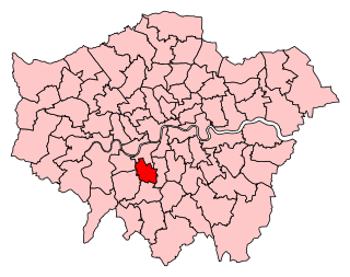
Tooting is a constituency created in 1974 in Greater London. It is represented in the House of Commons of the UK Parliament since 2016 by Dr. Rosena Allin-Khan, a member of the Labour Party.

<span class="mw-page-title-main">Parliamentary constituencies in London</span>

The region of Greater London, including the City of London, is divided into 73 parliamentary constituencies which are sub-classified as borough constituencies, affecting the type of electoral officer and level of expenses permitted.

<span class="mw-page-title-main">Penge Urban District</span>

Penge was a civil parish and a local government district located to the southeast of London, England. It included the settlements of Penge, Anerley and part of Crystal Palace. It was part of the London postal district, Metropolitan Police District and, from 1933, the London Passenger Transport Area. In 1965 the urban district was abolished by the London Government Act 1963 and it became part of Greater London, being combined with other districts to form the London Borough of Bromley.

<span class="mw-page-title-main">London Government Act 1963</span> United Kingdom legislation

The London Government Act 1963 is an Act of the Parliament of the United Kingdom, which created Greater London and a new local government structure within it. The Act significantly reduced the number of local government districts in the area, resulting in local authorities responsible for larger areas and populations. The upper tier of local government was reformed to cover the whole of the Greater London area and with a more strategic role; and the split of functions between upper and lower tiers was recast. The Act classified the boroughs into inner and outer London groups. The City of London and its corporation were essentially unreformed by the legislation. Subsequent amendments to the Act have significantly amended the upper tier arrangements, with the Greater London Council abolished in 1986, and the Greater London Authority introduced in 2000. As of 2016, the London boroughs are more or less identical to those created in 1965, although with some enhanced powers over services such as waste management and education.

<span class="mw-page-title-main">Parks and open spaces in the London Borough of Wandsworth</span>

The inner London borough of Wandsworth contains some 670 hectares of green space in the form of parks, commons, allotments and cemeteries, which is the largest amount for an Inner London borough. Central London borders some of the borough's boundary with the Thames the closest park to which is Battersea Park.

Wandsworth Central was a parliamentary constituency in the Wandsworth district of South London. It returned one Member of Parliament (MP) to the House of Commons of the Parliament of the United Kingdom, elected by the first-past-the-post voting system.

<span class="mw-page-title-main">Tooting Commons</span> Two adjacent areas of common land in south west London, England

The Tooting Commons consist of two adjacent areas of common land lying between Balham, Streatham and Tooting, in south west London: Tooting Bec Common and Tooting Graveney Common.

Lambeth was a constituency 1832—1885 loosely equivalent in area to the later administrative units: the London Borough of Lambeth and the south-west and centre of the London Borough of Southwark. It returned two members of parliament (MPs) to the House of Commons of the UK Parliament by the bloc vote version of the first-past-the-post system.

Wandsworth was the name of a borough constituency created in 1885, abolished in 1918, covering the vast bulk of today's London Borough of Wandsworth in South London but excluding Battersea. It returned one Member of Parliament (MP) to the House of Commons of the UK Parliament.

<span class="mw-page-title-main">Garratt Lane</span>

Garratt Lane is a long street in the London Borough of Wandsworth, part of the A217 road. It connects Wandsworth High Street to Tooting Broadway and is approximately 4 kilometres long. It passes through the Earlsfield and Summerstown neighbourhoods which were fields of Wandsworth before their development in the late 19th century.

<span class="mw-page-title-main">Wandsworth District (Metropolis)</span>

Wandsworth was a local government district within the metropolitan area of London, England from 1855 to 1900. It was formed by the Metropolis Management Act 1855 and was governed by the Wandsworth District Board of Works, which consisted of elected vestrymen.

References

  1. 1 2 3 Mills, A., Oxford Dictionary of London Place Names, (2001)
  2. Brixges Stane, the Meeting Place of the Brixton Hundred in Surrey, Graham Gower, Local History Publications 1996 ISBN   978-1-873520-20-8
  3. British History Online - Map of Brixton hundred
  4. Vision of Britain - Brixton hundred - area (historic map Archived 2007-10-01 at the Wayback Machine )
  5. John Marius Wilson's Imperial Gazetteer of England and Wales , (1870-72)
  6. John Bartholomew, Gazetteer of the British Isles, (1887)
  7. British History Online - The hundred of Brixton
  8. Open Domesday Online: Brixton Hundred, accessed July 2018.
  9. John Marius Wilson, Imperial Gazetteer of England and Wales (1870-72)
  10. Youngs, Frederic (1979). Guide to the Local Administrative Units of England. Vol. I: Southern England. London: Royal Historical Society. ISBN   0-901050-67-9.