
Kadina is a town on the Yorke Peninsula of the Australian state of South Australia, approximately 144 kilometres north-northwest of the state capital of Adelaide. The largest town of the Peninsula, Kadina is one of the three Copper Triangle towns famous for their shared copper mining history. The three towns are known as "Little Cornwall" for the significant number of immigrants from Cornwall who worked at the mines in the late 19th century.

Bute is a town in the Northern Yorke peninsula of South Australia, approximately 40 kilometres (25 mi) east of Wallaroo and 24 kilometres west of Snowtown. It was proclaimed as a town in 1884 and named after the Isle of Bute, in the Firth of Clyde, Scotland. It was the original site of the Yorke Peninsula Field Days in 1895; they are now held outside Paskeville.
Cooltong is a town and locality in the Australian state of South Australia. At the 2011 census, Cooltong had a population of 317.

Yacka is a small town in the shallow valley of the Broughton River in the Mid North of South Australia. It lies where the Horrocks Highway crosses the Broughton River midway between Clare and Gladstone. It was also a station on the Gladstone-Balaklava railway, built as narrow gauge in 1894, converted to broad gauge in 1927 and closed by 1993.
Caltowie is a town in the Mid North region of South Australia. It is on the Wilkins Highway and the Crystal Brook-Broken Hill railway line between Gladstone and Jamestown.

The Hundred of Belvidere is a cadastral unit of hundred located in the north Barossa Valley of South Australia in the County of Light.
Peebinga is a town and locality in the Australian state of South Australia. Peebinga was the terminus of the Peebinga railway line which was built in 1914 as part of a major state government project to open up the Murray Mallee for grazing and cropping.
Ucolta is a locality in the Mid North region of South Australia. It is named for a railway station on the Broken Hill-Port Pirie railway line. Trains no longer stop at Ucolta. It is also where the Barrier Highway first meets the railway line, and the Wilmington–Ucolta Road which connects across the northern side of the Mid North, providing the shortest road route from Western Australia and Eyre Peninsula via Port Augusta to Broken Hill and New South Wales.
Hart is a locality in the Mid North region of South Australia. The boundaries were formalised in January 2000 for the long established name for the area. There was a railway siding at Hart on the Gladstone railway line. The major industry in the area is cereal crop growing.

The Hundred of Strathalbyn is a cadastral division of the County of Hindmarsh in South Australia. It lies west of the Adelaide Hills and east of Lake Alexandrina and includes at its southwestern extremity the town of Strathalbyn. Its name is derived from that used for a sub-division granted in 1841. No definitive derivation for the subdivision of Strathalbyn name is known but it is deemed probable that John Rankine or his brother William provided the name with the meaning given as "white valley" from the Scottish srath and albion. Mount Barker Creek forms much of the northern hundred boundary while the Bremer River forms the eastern border.
Willalooka is a small service town and locality in the Limestone Coast region of South Australia. it is located on the Riddoch Highway between Keith and Padthaway. Christmas Rocks Conservation Park is north of the town adjacent to the highway.

The County of Jervois is a cadastral unit in the Australian state of South Australia that covers land on the east coast of the Eyre Peninsula. It was proclaimed on 24 January 1878 and named after William Jervois, the Governor of South Australia from October 1877 to January 1883.

The Hundred of Ninnes is a cadastral unit of hundred located in the Mid North of South Australia centred on the Ninnes Plain. It is one of the 16 hundreds of the County of Daly and was proclaimed by Governor Anthony Musgrave on the last day of 1874.

The Hundred of Yongala is a cadastral unit of hundred located in the Mid North of South Australia. It is one of the 12 hundreds of the County of Dalhousie and was proclaimed by Governor James Fergusson in 1871. The eponymous township of Yongala lies in the west of the hundred and the larger township of Peterborough in the north east. The locality of Sunnybrae occupies the remainder of the hundred.

The Hundred of Tarcowie is a cadastral unit of hundred located on the south western slopes of the Narien Range in the Mid North of South Australia spanning the township of Tarcowie, the locality of Hornsdale, and surrounds. One of the 12 hundreds of the County of Dalhousie, it was proclaimed in 1871 by Governor James Fergusson and named for an indigenous term thought to mean 'wash away water'.

The Hundred of Barossa is a cadastral unit of hundred in South Australia in the northern Adelaide Hills. It lies west of the Barossa Range at the south end of the Barossa Valley and is bounded on the north and south by the North Para and South Para rivers, respectively. It is the most northern of the eleven hundreds of the County of Adelaide and was named in 1846 by Governor Frederick Robe after the Barossa Range.

The Hundred of Bartlett is a cadastral hundred of South Australia located in the remote County of Way. It was created in 1889.
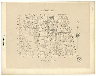
The Hundred of Townsend is a cadastral unit of hundred located in the Limestone Coast region in the south-east of South Australia.

The County of Frome is one of the 49 cadastral counties of South Australia in straddling the Mid North and Flinders Ranges regions. It was proclaimed in 1851 by Governor Henry Young and was named for the former Surveyor-General of South Australia, Edward Charles Frome. The iconic Mount Remarkable in the Hundred of Gregory is at the centre of the county.

The Hundred of Yackamoorundie is a cadastral unit of hundred in the County of Stanley, South Australia.
