
Peterborough is a town in the mid north of South Australia, in wheat country, just off the Barrier Highway. At the 2016 census, Peterborough had a population of 1,419. It was originally named Petersburg after the landowner, Peter Doecke, who sold land to create the town. It was one of 69 places in South Australia renamed in 1917 due to anti-German sentiments during World War I.

The District Council of Peterborough is a local government area in the Yorke and Mid North region of South Australia. The principal town and council seat is Peterborough; it also includes the localities of Cavenagh, Dawson, Hardy, Minvalara, Nackara, Oodla Wirra, Paratoo, Parnaroo, Sunnybrae, Ucolta and Yongala.

Bute is a town in the Northern Yorke peninsula of South Australia, approximately 40 kilometres (25 mi) east of Wallaroo and 24 kilometres west of Snowtown. It was proclaimed as a town in 1884 and named after the Isle of Bute, in the Firth of Clyde, Scotland. It was the original site of the Yorke Peninsula Field Days in 1895; they are now held outside Paskeville.
Yongala is a small town located in the state of South Australia, Australia. It has a population of approximately 240 people and is situated on the Clare-Peterborough Road (B79), 238 km from Adelaide, the state capital.
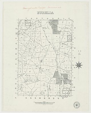
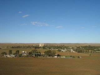
Eurelia is a town and locality in the Australian state of South Australia located on the east side of the Flinders Ranges about 264 kilometres (164 mi) north of the state capital of Adelaide and about 20 kilometres (12 mi) from the municipal seat of Orroroo.
Whyte Yarcowie is a town and locality in the Australian state of South Australia. It is on the Barrier Highway between Hallett and Terowie.
Ucolta is a locality in the Mid North region of South Australia. It is named for a railway station on the Broken Hill-Port Pirie railway line. Trains no longer stop at Ucolta. It is also where the Barrier Highway first meets the railway line, and the Wilmington–Ucolta Road which connects across the northern side of the Mid North, providing the shortest road route from Western Australia and Eyre Peninsula via Port Augusta to Broken Hill and New South Wales.

The District Council of Coglin was a local government area in South Australia. It came into operation on 5 January 1888 under the provisions of the District Councils Act 1887. At its inception, it comprised the Hundreds of Cavenagh, Coglin, Gumbowie, Parnaroo, Hardy, Nackara, and Paratoo. It was divided into four wards: Coglin, Gumbowie, East and North. Meetings were held alternately at Dawson and Lancelot until 1899, and thereafter at Penn.
The District Council of Yongala was a local government area in South Australia from 1883 to 1935, seated at Yongala.

The Corporate Town of Peterborough was a local government area in South Australia centred on the town of Peterborough. It came into existence on 7 October 1886 when it separated from the surrounding District Council of Yongala. It was initially known as Petersburg; it was renamed Peterborough on 10 January 1918, one of many South Australian places to be renamed as a consequence of World War I. It gained additional sections from the Yongala council on 30 August 1888 and 25 November 1897, but lost some territory in 1935 when Yongala amalgamated with the adjacent District Council of Coglin to create the District Council of Peterborough. The two municipalities would coexist alongside each other, the town surrounded by the district council, for more than sixty years.
The District Council of Jamestown was a local government area in South Australia, centred on the region surrounding the town of Jamestown. The District Council came into existence on 21 March 1935 following the amalgamation of 95% of the District Council of Belalie with the District Council of Caltowie and the Hundred of Mannanarie, which had been in the abolished District Council of Yongala. For almost all of its history, it surrounded but did not include the town of Jamestown itself; the Jamestown township had separated from Belalie as the Corporate Town of Jamestown in 1878, and would not merge back into the broader municipality until 1991.
The County of Dalhousie is one of the 49 cadastral counties of South Australia in straddling the Mid North and Flinders Ranges regions. It was proclaimed in 1871 by Governor James Fergusson and was named for Fergusson's father-in-law James Broun-Ramsay, 1st Marquess of Dalhousie.
The District Council of Munno Mara West was a local government area of South Australia on the central Adelaide Plains from 1854 to 1933.
The Hundred of Caltowie is a cadastral unit of hundred in South Australia centred on the township of Caltowie. It is one of the 14 hundreds of the County of Victoria and was proclaimed by Governor James Fergusson in July 1871.

The Hundred of Kadina is a cadastral unit of hundred located on the north-western Yorke Peninsula in South Australia. It is one of the 16 hundreds of the County of Daly and was proclaimed by Governor Dominick Daly on 12 June 1862.

The Hundred of Tarcowie is a cadastral unit of hundred located on the south western slopes of the Narien Range in the Mid North of South Australia spanning the township of Tarcowie, the locality of Hornsdale, and surrounds. One of the 12 hundreds of the County of Dalhousie, it was proclaimed in 1871 by Governor James Fergusson and named for an indigenous term thought to mean 'wash away water'.
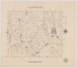
Cavenagh is a locality in the Australian state of South Australia located about 247 kilometres (153 mi) north of the state capital of Adelaide and about 37 kilometres (23 mi) north-east of the municipal seat in Peterborough.
Hardy is a locality in the Australian state of South Australia located about 231 kilometres (144 mi) north of the state capital of Adelaide and about 40 kilometres (25 mi) east of the municipal seat in Peterborough.

County of Kimberley is a cadastral unit located in the Australian state of South Australia that covers land to the east of the Flinders Ranges about 45 kilometres (28 mi) east of the town of Peterborough. It was proclaimed in 1871 and named after John Wodehouse, 1st Earl of Kimberley, a British Secretary of State for the Colonies. It has been partially divided in the following sub-units of hundreds – Gumbowie, Hardy, Ketchowla, Parnaroo, Terowie and Wonna.
The District Council of Kapunda was a local government area in South Australia from 1866 to 1996. The Kapunda town corporation was formed a year earlier in 1865 and ultimately amalgamated into the district council.


