Hungduan, Ifugao

Last updated
Hungduan
Municipality of Hungduan
Hapao Rice Terraces (a).jpg
Hapao Rice Terraces in Hungduan
Ph locator ifugao hungduan.png
Map of Ifugao with Hungduan highlighted
OpenStreetMap
Hungduan, Ifugao
Philippines location map (square).svg
Red pog.svg
Hungduan
Location within the Philippines
Coordinates: 16°50′N121°00′E / 16.83°N 121°E / 16.83; 121 Coordinates: 16°50′N121°00′E / 16.83°N 121°E / 16.83; 121
Country Flag of the Philippines.svg  Philippines
Region Cordillera Administrative Region (CAR)
Province Ifugao
District Lone District
Barangays 9 (see Barangays)
Government
[1]
  Type Sangguniang Bayan
   Mayor Casan P. Dumulag
   Vice Mayor Lucas A. Bugatti
  CongressmanSolomon R. Chungalao
  Electorate6,293 voters (2019)
Area
[2]
  Total260.30 km2 (100.50 sq mi)
Population
 (2015 census) [3]
  Total9,400
  Density36/km2 (94/sq mi)
  Households
1,939
Economy
   Income class 4th municipal income class
   Poverty incidence 27.02% (2015) [4]
  Revenue (₱)71,484,065.62 (2016)
Time zone UTC+8 (PST)
ZIP code
3603
PSGC
IDD : area code +63(0)74
Climate type tropical rainforest climate
Native languagesIfugao language
Kallahan language
Tuwali language
Ilocano
Tagalog

Hungduan, officially the Municipality of Hungduan is a 4th class municipality in the province of Ifugao, Philippines. According to the 2015 census, it has a population of 9,400 people. [3]

Contents

It is bounded on the north-east by the town of Banaue in the east by Hingyon and on the southeast by the town of Kiangan. It borders in the south with the town of Tinoc, Ifugao. On its westside, the town is bordered by the towns of Sabangan and Bauko, Mountain Province.

Barangays

Hungduan is politically subdivided into 9 barangays. [2]

Climate

Climate data for Hungduan, Ifugao
MonthJanFebMarAprMayJunJulAugSepOctNovDecYear
Average high °C (°F)21
(70)
22
(72)
24
(75)
25
(77)
25
(77)
25
(77)
24
(75)
24
(75)
24
(75)
24
(75)
23
(73)
21
(70)
24
(74)
Average low °C (°F)14
(57)
15
(59)
16
(61)
18
(64)
19
(66)
19
(66)
19
(66)
19
(66)
19
(66)
17
(63)
16
(61)
15
(59)
17
(63)
Average precipitation mm (inches)35
(1.4)
46
(1.8)
63
(2.5)
117
(4.6)
402
(15.8)
400
(15.7)
441
(17.4)
471
(18.5)
440
(17.3)
258
(10.2)
94
(3.7)
68
(2.7)
2,835
(111.6)
Average rainy days9.911.113.918.926.027.328.928.526.119.714.512.8237.6
Source: Meteoblue [5]

Demographics

Population census of Hungduan
YearPop.±% p.a.
1939 12,937    
1948 3,540−13.41%
1960 7,603+6.58%
1970 8,958+1.65%
1975 12,301+6.57%
1980 9,857−4.33%
1990 7,254−3.02%
1995 9,491+5.17%
2000 9,380−0.25%
2007 9,601+0.32%
2015 9,400−0.26%
Source: Philippine Statistics Authority [3] [6] [7] [8]

In the 2015 census, the population of Hungduan was 9,400 people, [3] with a density of 36 inhabitants per square kilometre or 93 inhabitants per square mile.

Related Research Articles

Luna, Apayao Municipality in Cordillera Administrative Region, Philippines

Luna, officially the Municipality of Luna,, is a 2nd class municipality in the province of Apayao, Philippines. According to the 2015 census, it has a population of 19,063 people.

Aguinaldo, Ifugao Municipality in Cordillera Administrative Region, Philippines

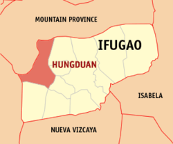
Aguinaldo, officially the Municipality of Aguinaldo, is a 2nd class municipality in the province of Ifugao, Philippines. According to the 2015 census, it has a population of 19,408 people.

Daguioman Municipality in Cordillera Administrative Region, Philippines

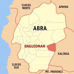
Daguioman, officially the Municipality of Daguioman, is a 5th class municipality in the province of Abra, Philippines. According to the 2015 census, it had a population of 2,088 people.

Lacub Municipality in Cordillera Administrative Region, Philippines

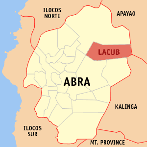
Lacub, officially the Municipality of Lacub, is a 5th class municipality in the province of Abra, Philippines. According to the 2015 census, it has a population of 3,403 people.

Langiden Municipality in Cordillera Administrative Region, Philippines

Langiden, officially the Municipality of Langiden, is a 5th class municipality in the province of Abra, Philippines. According to the 2015 census, it has a population of 3,198 people.

Licuan-Baay Municipality in Cordillera Administrative Region, Philippines

Licuan-Baay, officially the Municipality of Licuan-Baay, is a 5th class municipality in the province of Abra, Philippines. According to the 2015 census, it has a population of 4,689 people.

Pilar, Abra Municipality in Cordillera Administrative Region, Philippines

Pilar, officially the Municipality of Pilar, is a municipality in the province of Abra in the Cordillera Administrative Region (CAR) of the Philippines. The population was 10,223 at the 2015 census.

Conner, Apayao Municipality in Cordillera Administrative Region, Philippines

Conner, officially the Municipality of Conner,, is a 2nd class municipality in the province of Apayao, Philippines. According to the 2015 census, it has a population of 26,051 people.

Kabugao Municipality in Cordillera Administrative Region, Philippines

Kabugao, officially the Municipality of Kabugao,, is a 1st class municipality and capital of the province of Apayao, Philippines. According to the 2015 census, it has a population of 15,537 people.

Rizal, Kalinga Municipality in Cordillera Administrative Region, Philippines

Rizal, officially the Municipality of Rizal is a 4th class municipality in the province of Kalinga, Philippines. According to the 2015 census, it has a population of 17,038 people.

Bakun, Benguet Municipality in Cordillera Administrative Region, Philippines

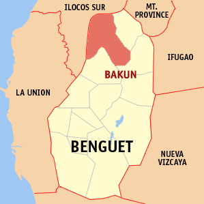
Bakun, officially the Municipality of Bakun,, is a 3rd class municipality in the province of Benguet, Philippines. According to the 2015 census, it has a population of 15,357 people.

Alfonso Lista, Ifugao Municipality in Cordillera Administrative Region, Philippines

Alfonso Lista, formerly known as Potia, officially the Municipality of Alfonso Lista is a 3rd class municipality in the province of Ifugao, Philippines. According to the 2015 census, it has a population of 32,119 people.

Asipulo, Ifugao Municipality in Cordillera Administrative Region, Philippines

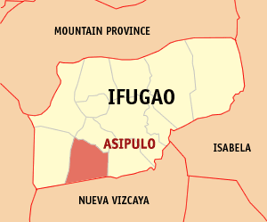
Asipulo, officially the Municipality of Asipulo is a 5th class municipality in the province of Ifugao, Philippines. According to the 2015 census, it has a population of 15,261 people.

Banaue Municipality in Cordillera Administrative Region, Philippines

Banaue, officially the Municipality of Banaue is a 4th class municipality in the province of Ifugao, Philippines. According to the 2015 census, it has a population of 21,837 people.

Hingyon, Ifugao Municipality in Cordillera Administrative Region, Philippines

Hingyon, officially the Municipality of Hingyon is a 5th class municipality in the province of Ifugao, Philippines. According to the 2015 census, it has a population of 9,227 people.

Kiangan, Ifugao Municipality in Cordillera Administrative Region, Philippines

Kiangan, officially the Municipality of Kiangan is a 4th class municipality in the province of Ifugao, Philippines. According to the 2015 census, it has a population of 17,048 people.

Lagawe, Ifugao Municipality in Cordillera Administrative Region, Philippines

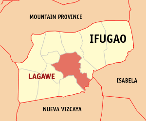
Lagawe, officially the Municipality of Lagawe is a 4th class municipality and capital of the province of Ifugao, Philippines. According to the 2015 census, it has a population of 19,333 people.

Lamut, Ifugao Municipality in Cordillera Administrative Region, Philippines

Lamut, officially the Municipality of Lamut is a 4th class municipality in the province of Ifugao, Philippines. According to the 2015 census, it has a population of 25,279 people.

Mayoyao, Ifugao Municipality in Cordillera Administrative Region, Philippines

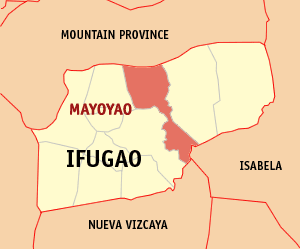
Mayoyao, officially the Municipality of Mayoyao is a 4th class municipality in the province of Ifugao, Philippines. According to the 2015 census, it has a population of 17,331 people.

Tinoc, Ifugao Municipality in Cordillera Administrative Region, Philippines

Tinoc, officially the Municipality of Tinoc is a 4th class municipality in the province of Ifugao, Philippines. According to the 2015 census, it has a population of 16,559 people.

References

  1. "Municipality". Quezon City, Philippines: Department of the Interior and Local Government. Retrieved 31 May 2013.
  2. 1 2 "Province: Ifugao". PSGC Interactive. Quezon City, Philippines: Philippine Statistics Authority . Retrieved 12 November 2016.
  3. 1 2 3 4 Census of Population (2015). "Cordillera Administrative Region (CAR)". Total Population by Province, City, Municipality and Barangay. PSA . Retrieved 20 June 2016.
  4. "PSA releases the 2015 Municipal and City Level Poverty Estimates". Quezon City, Philippines. Retrieved 12 October 2019.
  5. "Hungduan: Average Temperatures and Rainfall". Meteoblue. Retrieved 8 March 2020.
  6. Census of Population and Housing (2010). "Cordillera Administrative Region (CAR)". Total Population by Province, City, Municipality and Barangay. NSO . Retrieved 29 June 2016.
  7. Censuses of Population (1903–2007). "Cordillera Administrative Region (CAR)". Table 1. Population Enumerated in Various Censuses by Province/Highly Urbanized City: 1903 to 2007. NSO.
  8. "Province of Ifugao". Municipality Population Data. Local Water Utilities Administration Research Division. Retrieved 17 December 2016.