Kiangan, Ifugao

Last updated
Kiangan
Municipality of Kiangan
Nagacadan Rice Terraces.jpg
Nagacadan Rice Terraces
Ph locator ifugao kiangan.png
Map of Ifugao with Kiangan highlighted
Philippines location map (square).svg
Red pog.svg
Kiangan
Location within the Philippines
Coordinates: 16°47′N121°05′E / 16.78°N 121.08°E / 16.78; 121.08 Coordinates: 16°47′N121°05′E / 16.78°N 121.08°E / 16.78; 121.08
Country Flag of the Philippines.svg  Philippines
Region Cordillera Administrative Region (CAR)
Province Ifugao
District Lone District
Barangays 14 (see Barangays)
Government
[1]
  Type Sangguniang Bayan
   Mayor Raldis Andrei A. Bulayungan
   Vice Mayor Michelle Alice B. Baguilat
  CongressmanSolomon R. Chungalao
  Electorate11,671 voters (2019)
Area
[2]
  Total200.00 km2 (77.22 sq mi)
Population
 (2015 census) [3]
  Total17,048
  Density85/km2 (220/sq mi)
Economy
   Income class 4th municipal income class
   Poverty incidence 24.2% (2015) [4]
  Revenue (₱)75,117,494.00 (2016)
Time zone UTC+8 (PST)
ZIP code
3604
PSGC
IDD : area code +63(0)74
Climate type tropical rainforest climate
Native languagesIfugao language
Kallahan language
Tuwali language
Ilocano
Tagalog
Website kiangan.gov.ph

Kiangan, officially the Municipality of Kiangan is a 4th class municipality in the province of Ifugao, Philippines. According to the 2015 census, it has a population of 17,048 people. [3]

Contents

Kiangan is the oldest town in the province. It derives its name from Kiyyangan, an ancient village near the bank of the Ibulao River across the Lagawe valley. The name Kiyyangan is enshrined in Ifugao mythology and is believed to be the dwelling of Wigan and Bugan, the mythological ancestors of the Ifugao. It was the former capital of Ifugao until the topology was deemed unfit and moved to neighboring Lagawe.

The Nagacadan Rice Terraces are part of the Rice Terraces of the Philippine Cordilleras World Heritage Site.

Barangays

Kiangan is politically subdivided into 14 barangays. [2]

Climate

Climate data for Kiangan, Ifugao
MonthJanFebMarAprMayJunJulAugSepOctNovDecYear
Average high °C (°F)21
(70)
22
(72)
24
(75)
25
(77)
25
(77)
25
(77)
24
(75)
24
(75)
24
(75)
24
(75)
23
(73)
21
(70)
24
(74)
Average low °C (°F)14
(57)
15
(59)
16
(61)
18
(64)
19
(66)
19
(66)
19
(66)
19
(66)
19
(66)
17
(63)
16
(61)
15
(59)
17
(63)
Average precipitation mm (inches)35
(1.4)
46
(1.8)
63
(2.5)
117
(4.6)
402
(15.8)
400
(15.7)
441
(17.4)
471
(18.5)
440
(17.3)
258
(10.2)
94
(3.7)
68
(2.7)
2,835
(111.6)
Average rainy days9.911.113.918.926.027.328.928.526.119.714.512.8237.6
Source: Meteoblue [5]

Demographics

Population census of Kiangan
YearPop.±% p.a.
1918 37,161    
1939 16,146−3.89%
1948 10,534−4.63%
1960 12,689+1.56%
1970 15,123+1.77%
1975 15,935+1.05%
1980 17,481+1.87%
1990 21,329+2.01%
1995 13,514−8.20%
2000 14,099+0.91%
2007 15,448+1.27%
2010 15,837+0.91%
2015 17,048+1.41%
Source: Philippine Statistics Authority [3] [6] [7] [8]

In the 2015 census, the population of Kiangan, Ifugao, was 17,048 people, [3] with a density of 85 inhabitants per square kilometre or 220 inhabitants per square mile.

Locally spoken languages include Tuwali, Ayangan, Ilocano, Tagalog, and English.

Economy

Agriculture and tourism are the main sources of local economic activities which supports commerce and trade among townsfolk. Its terraced rice fields do not only provide produce for the farmers but attract tourists as well.

Culture

War Memorial Shrine (Kiangan, Ifugao) (2141831843).jpg
Kiangan war memorial.jpg
War memorial

The Nagacadan Rice Terraces is a UNESCO Heritage Site and one of the many rice terraces in the province of Ifugao. The rice terraces cluster manifest a distinct feature - the fields are in ascending rows of terraces bisected by a river.

Located in Kiangan is the Kiangan Central School old home economics building, which marks the spot where the highest Commander of the Japanese Imperial Army, General Tomoyuki Yamashita (also known as the Tiger of Malaya), surrendered to the Filipino & American Forces on 2 September 1945.

Ifugao museum in Kiangan.jpg
Yamashita surrender site in Kiangan.jpg
Ifugao Museum (left) and Yamashita surrender site (right)

Related Research Articles

Ifugao Province in Cordillera Administrative Region, Philippines

Ifugao is a landlocked province of the Philippines in the Cordillera Administrative Region in Luzon. Its capital is Lagawe and it borders Benguet to the west, Mountain Province to the north, Isabela to the east, and Nueva Vizcaya to the south.

Mountain Province Province in Cordillera Administrative Region, Philippines

Mountain Province is a landlocked province of the Philippines in the Cordillera Administrative Region in Luzon. Its capital is Bontoc.

Aguinaldo, Ifugao Municipality in Cordillera Administrative Region, Philippines

Aguinaldo, officially the Municipality of Aguinaldo, is a 2nd class municipality in the province of Ifugao, Philippines. According to the 2015 census, it has a population of 19,408 people.

Bucloc Municipality in Cordillera Administrative Region, Philippines

Bucloc, officially the Municipality of Bucloc,, is a 6th class municipality in the province of Abra, Philippines. According to the 2015 census, it has a population of 2,501 people.

Langiden Municipality in Cordillera Administrative Region, Philippines

Langiden, officially the Municipality of Langiden,, is a 5th class municipality in the province of Abra, Philippines. According to the 2015 census, it has a population of 3,198 people.

Boliney Municipality in Cordillera Administrative Region, Philippines

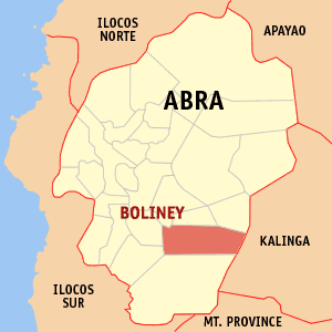
Boliney, officially the Municipality of Boliney,, is a 5th class municipality in the province of Abra, Philippines. According to the 2015 census, it has a population of 3,573 people.

San Quintin, Abra Municipality in Cordillera Administrative Region, Philippines

San Quintin, officially the Municipality of San Quintin,, is a 5th class municipality in the province of Abra, Philippines. According to the 2015 census, it has a population of 5,438 people.

Barlig Municipality in Cordillera Administrative Region, Philippines

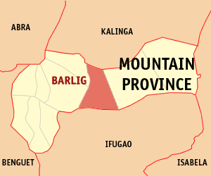
Barlig, officially the Municipality of Barlig is a 5th class municipality in the province of Mountain Province, Philippines. According to the 2015 census, it has a population of 4,819 people.

Natonin Municipality of the Philippines in the Mountain Province

Natonin, officially the Municipality of Natonin is a 4th class municipality in the province of Mountain Province, Philippines. According to the 2015 census, it has a population of 10,272 people.

Tanudan, Kalinga Municipality in Cordillera Administrative Region, Philippines

Tanudan, officially the Municipality of Tanudan is a 4th class municipality in the province of Kalinga, Philippines. According to the 2015 census, it has a population of 9,534 people.

Kibungan Municipality in Cordillera Administrative Region, Philippines

Kibungan, officially the Municipality of Kibungan,, is a 4th class municipality in the province of Benguet, Philippines. According to the 2015 census, it has a population of 17,292 people.

Alfonso Lista, Ifugao Municipality in Cordillera Administrative Region, Philippines

Alfonso Lista, formerly known as Potia, officially the Municipality of Alfonso Lista is a 3rd class municipality in the province of Ifugao, Philippines. According to the 2015 census, it has a population of 32,119 people.. It was created as the municipal district of Potia in 1955 from the barrios of Potia, Dolowog, San Juan, San Quintin, Cabicalan, Pinto, Busilac, Santa Maria, and Namillangan in the municipal district of Mayaoyao. In 1959 the name was changed to Alfonso Lista to memorialize the first mayor.

Asipulo, Ifugao Municipality in Cordillera Administrative Region, Philippines

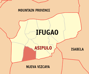
Asipulo, officially the Municipality of Asipulo is a 5th class municipality in the province of Ifugao, Philippines. According to the 2015 census, it has a population of 15,261 people.

Banaue Municipality in Cordillera Administrative Region, Philippines

Banaue, officially the Municipality of Banaue is a 4th class municipality in the province of Ifugao, Philippines. According to the 2015 census, it has a population of 21,837 people.

Hingyon, Ifugao Municipality in Cordillera Administrative Region, Philippines

Hingyon, officially the Municipality of Hingyon is a 5th class municipality in the province of Ifugao, Philippines. According to the 2015 census, it has a population of 9,227 people.

Hungduan, Ifugao Municipality in Cordillera Administrative Region, Philippines

Hungduan, officially the Municipality of Hungduan is a 4th class municipality in the province of Ifugao, Philippines. According to the 2015 census, it has a population of 9,400 people.

Lagawe, Ifugao Municipality in Cordillera Administrative Region, Philippines

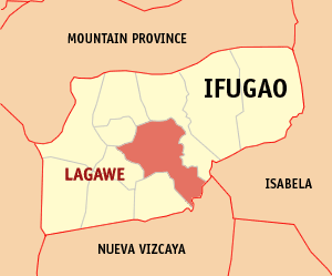
Lagawe, officially the Municipality of Lagawe is a 4th class municipality and capital of the province of Ifugao, Philippines. According to the 2015 census, it has a population of 19,333 people..

Lamut, Ifugao Municipality in Cordillera Administrative Region, Philippines

Lamut, officially the Municipality of Lamut is a 4th class municipality in the province of Ifugao, Philippines. According to the 2015 census, it has a population of 25,279 people.

Mayoyao, Ifugao Municipality in Cordillera Administrative Region, Philippines

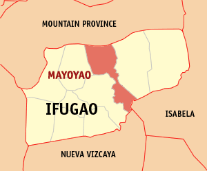
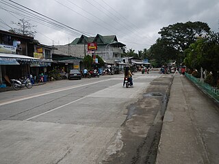
Mayoyao, officially the Municipality of Mayoyao is a 4th class municipality in the province of Ifugao, Philippines. According to the 2015 census, it has a population of 17,331 people.

Tinoc, Ifugao Municipality in Cordillera Administrative Region, Philippines

Tinoc, officially the Municipality of Tinoc is a 4th class municipality in the province of Ifugao, Philippines. According to the 2015 census, it has a population of 16,559 people.

References

  1. "Municipality". Quezon City, Philippines: Department of the Interior and Local Government. Retrieved 31 May 2013.
  2. 1 2 "Province: Ifugao". PSGC Interactive. Quezon City, Philippines: Philippine Statistics Authority . Retrieved 12 November 2016.
  3. 1 2 3 4 Census of Population (2015). "Cordillera Administrative Region (CAR)". Total Population by Province, City, Municipality and Barangay. PSA . Retrieved 20 June 2016.
  4. "PSA releases the 2015 Municipal and City Level Poverty Estimates". Quezon City, Philippines. Retrieved 12 October 2019.
  5. "Kiangan: Average Temperatures and Rainfall". Meteoblue. Retrieved 8 March 2020.
  6. Census of Population and Housing (2010). "Cordillera Administrative Region (CAR)". Total Population by Province, City, Municipality and Barangay. NSO . Retrieved 29 June 2016.
  7. Censuses of Population (1903–2007). "Cordillera Administrative Region (CAR)". Table 1. Population Enumerated in Various Censuses by Province/Highly Urbanized City: 1903 to 2007. NSO.
  8. "Province of Ifugao". Municipality Population Data. Local Water Utilities Administration Research Division. Retrieved 17 December 2016.