Lagawe, Ifugao

Last updated
Lagawe
Municipality of Lagawe
Ph seal Lagawe, Ifugao.png
Seal
Ph locator ifugao lagawe.png
Map of Ifugao with Lagawe highlighted
Lagawe, Ifugao
Philippines location map (square).svg
Red pog.svg
Lagawe
Location within the Philippines
Coordinates: 16°49′N121°06′E / 16.82°N 121.1°E / 16.82; 121.1 Coordinates: 16°49′N121°06′E / 16.82°N 121.1°E / 16.82; 121.1
Country Flag of the Philippines.svg  Philippines
Region Cordillera Administrative Region (CAR)
Province Ifugao
District Lone District
Founded1961
Barangays 20 (see Barangays)
Government
[1]
  Type Sangguniang Bayan
   Mayor Martin L. Habawel, Jr.
   Vice Mayor Reynold A. Kimayong
  CongressmanSolomon R. Chungalao
  Electorate11,895 voters (2019)
Area
[2]
  Total208.91 km2 (80.66 sq mi)
Elevation
490.2 m (1,608.3 ft)
Population
 (2015 census) [3]
  Total19,333
  Density93/km2 (240/sq mi)
  Households
3,944
Economy
   Income class 4th municipal income class
   Poverty incidence 19.68% (2015) [4]
  Revenue (₱)85,847,702.37 (2016)
Time zone UTC+8 (PST)
ZIP code
3600
PSGC
IDD : area code +63(0)74
Climate type tropical rainforest climate
Native languagesIfugao language
Tuwali language
Ilocano
Tagalog
Website www.lagawe.gov.ph

Lagawe (Ilocano : Ili ti Lagawe), officially the Municipality of Lagawe is a 4th class municipality and capital of the province of Ifugao, Philippines. According to the 2015 census, it has a population of 19,333 people. [3]

Contents

Barangays

Lagawe is politically subdivided into 20 barangays. [2]

Climate

Climate data for Lagawe, Ifugao
MonthJanFebMarAprMayJunJulAugSepOctNovDecYear
Average high °C (°F)25
(77)
26
(79)
28
(82)
30
(86)
29
(84)
29
(84)
28
(82)
28
(82)
28
(82)
28
(82)
27
(81)
26
(79)
28
(82)
Average low °C (°F)18
(64)
19
(66)
20
(68)
22
(72)
23
(73)
23
(73)
23
(73)
23
(73)
23
(73)
21
(70)
20
(68)
19
(66)
21
(70)
Average precipitation mm (inches)38
(1.5)
57
(2.2)
77
(3.0)
141
(5.6)
390
(15.4)
355
(14.0)
426
(16.8)
441
(17.4)
426
(16.8)
259
(10.2)
97
(3.8)
57
(2.2)
2,764
(108.9)
Average rainy days10.412.115.420.426.727.128.728.026.419.914.112.3241.5
Source: Meteoblue [5]

Demographics

Population census of Lagawe
YearPop.±% p.a.
1939 13,204    
1948 12,424−0.67%
1960 13,694+0.81%
1970 14,085+0.28%
1975 13,948−0.20%
1980 15,075+1.57%
1990 12,437−1.91%
1995 14,898+3.44%
2000 15,269+0.53%
2007 17,477+1.88%
2010 18,077+1.24%
2015 19,333+1.29%
Source: Philippine Statistics Authority [3] [6] [7] [8]

In the 2015 census, the population of Lagawe, Ifugao, was 19,333 people, [3] with a density of 93 inhabitants per square kilometre or 240 inhabitants per square mile.

Related Research Articles

Bauko Municipality in Cordillera Administrative Region, Philippines

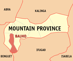
Bauko, officially the Municipality of Bauko is a 4th class municipality in the province of Mountain Province, Philippines. According to the 2015 census, it has a population of 31,065 people.

Aguinaldo, Ifugao Municipality in Cordillera Administrative Region, Philippines

Aguinaldo, officially the Municipality of Aguinaldo, is a 2nd class municipality in the province of Ifugao, Philippines. According to the 2015 census, it has a population of 19,408 people.

Manabo Municipality in Cordillera Administrative Region, Philippines

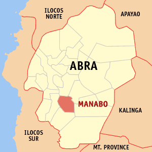
Manabo, officially the Municipality of Manabo, is a 5th class municipality in the province of Abra, Philippines. According to the 2015 census, it has a population of 10,761 people.

Pilar, Abra Municipality in Cordillera Administrative Region, Philippines

Pilar, officially the Municipality of Pilar, is a municipality in the province of Abra in the Cordillera Administrative Region (CAR) of the Philippines. The population was 10,223 at the 2015 census.

Sabangan Municipality in Cordillera Administrative Region, Philippines

Sabangan, officially the Municipality of Sabangan is a 5th class municipality in the province of Mountain Province, Philippines. According to the 2015 census, it has a population of 9,315 people.

Flora, Apayao Municipality in Cordillera Administrative Region, Philippines

Flora, officially the Municipality of Flora, is a 3rd class municipality in the province of Apayao, Philippines. According to the 2015 census, it has a population of 17,391 people.

Pasil, Kalinga Municipality in Cordillera Administrative Region, Philippines

Pasil, officially the Municipality of Pasil is a 5th class municipality in the province of Kalinga, Philippines. According to the 2015 census, it has a population of 9,644 people.

Pinukpuk, Kalinga Municipality in Cordillera Administrative Region, Philippines

Pinukpuk, officially the Municipality of Pinukpuk is a 1st class municipality in the province of Kalinga, Philippines. According to the 2015 census, it has a population of 32,026 people.

Rizal, Kalinga Municipality in Cordillera Administrative Region, Philippines

Rizal, officially the Municipality of Rizal is a 4th class municipality in the province of Kalinga, Philippines. According to the 2015 census, it has a population of 17,038 people.

Tanudan, Kalinga Municipality in Cordillera Administrative Region, Philippines

Tanudan, officially the Municipality of Tanudan is a 4th class municipality in the province of Kalinga, Philippines. According to the 2015 census, it has a population of 9,534 people.

Tinglayan, Kalinga Municipality in Cordillera Administrative Region, Philippines

Tinglayan, officially the Municipality of Tinglayan is a 4th class municipality in the province of Kalinga, Philippines. According to the 2015 census, it has a population of 12,868 people.

Alfonso Lista, Ifugao Municipality in Cordillera Administrative Region, Philippines

Alfonso Lista, formerly known as Potia, officially the Municipality of Alfonso Lista is a 3rd class municipality in the province of Ifugao, Philippines. According to the 2015 census, it has a population of 32,119 people.

Asipulo, Ifugao Municipality in Cordillera Administrative Region, Philippines

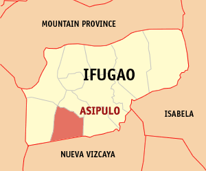
Asipulo, officially the Municipality of Asipulo is a 5th class municipality in the province of Ifugao, Philippines. According to the 2015 census, it has a population of 15,261 people.

Banaue Municipality in Cordillera Administrative Region, Philippines

Banaue, officially the Municipality of Banaue is a 4th class municipality in the province of Ifugao, Philippines. According to the 2015 census, it has a population of 21,837 people.

Hingyon, Ifugao Municipality in Cordillera Administrative Region, Philippines

Hingyon, officially the Municipality of Hingyon is a 5th class municipality in the province of Ifugao, Philippines. According to the 2015 census, it has a population of 9,227 people.

Hungduan, Ifugao Municipality in Cordillera Administrative Region, Philippines

Hungduan, officially the Municipality of Hungduan is a 4th class municipality in the province of Ifugao, Philippines. According to the 2015 census, it has a population of 9,400 people.

Kiangan, Ifugao Municipality in Cordillera Administrative Region, Philippines

Kiangan, officially the Municipality of Kiangan is a 4th class municipality in the province of Ifugao, Philippines. According to the 2015 census, it has a population of 17,048 people.

Lamut, Ifugao Municipality in Cordillera Administrative Region, Philippines

Lamut, officially the Municipality of Lamut is a 4th class municipality in the province of Ifugao, Philippines. According to the 2015 census, it has a population of 25,279 people.

Mayoyao, Ifugao Municipality in Cordillera Administrative Region, Philippines

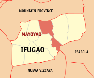
Mayoyao, officially the Municipality of Mayoyao is a 4th class municipality in the province of Ifugao, Philippines. According to the 2015 census, it has a population of 17,331 people.

Tinoc, Ifugao Municipality in Cordillera Administrative Region, Philippines

Tinoc, officially the Municipality of Tinoc is a 4th class municipality in the province of Ifugao, Philippines. According to the 2015 census, it has a population of 16,559 people.

References

  1. "Municipality". Quezon City, Philippines: Department of the Interior and Local Government. Retrieved 31 May 2013.
  2. 1 2 "Province: Ifugao". PSGC Interactive. Quezon City, Philippines: Philippine Statistics Authority . Retrieved 12 November 2016.
  3. 1 2 3 4 Census of Population (2015). "Cordillera Administrative Region (CAR)". Total Population by Province, City, Municipality and Barangay. PSA . Retrieved 20 June 2016.
  4. "PSA releases the 2015 Municipal and City Level Poverty Estimates". Quezon City, Philippines. Retrieved 12 October 2019.
  5. "Lagawe: Average Temperatures and Rainfall". Meteoblue. Retrieved 8 March 2020.
  6. Census of Population and Housing (2010). "Cordillera Administrative Region (CAR)". Total Population by Province, City, Municipality and Barangay. NSO . Retrieved 29 June 2016.
  7. Censuses of Population (1903–2007). "Cordillera Administrative Region (CAR)". Table 1. Population Enumerated in Various Censuses by Province/Highly Urbanized City: 1903 to 2007. NSO.
  8. "Province of Ifugao". Municipality Population Data. Local Water Utilities Administration Research Division. Retrieved 17 December 2016.