Balbalan, Kalinga

Last updated
Balbalan
Municipality of Balbalan
Ph locator kalinga balbalan.png
Map of Kalinga with Balbalan highlighted
OpenStreetMap
Balbalan, Kalinga
Philippines location map (square).svg
Red pog.svg
Balbalan
Location within the Philippines
Coordinates: 17°27′N121°09′E / 17.45°N 121.15°E / 17.45; 121.15 Coordinates: 17°27′N121°09′E / 17.45°N 121.15°E / 17.45; 121.15
Country Flag of the Philippines.svg  Philippines
Region Cordillera Administrative Region (CAR)
Province Kalinga
District Lone District
Barangays 14 (see Barangays)
Government
[1]
  Type Sangguniang Bayan
   Mayor Eric L. Gonayon
   Vice Mayor Winifredo B. Agapito
  CongressmanAllen Jesse C. Mangaoang
  Electorate9,151 voters (2019)
Area
[2]
  Total542.69 km2 (209.53 sq mi)
Elevation
999.8 m (3,280.2 ft)
Population
 (2015 census) [3]
  Total12,195
  Density22/km2 (58/sq mi)
  Households
2,301
Economy
   Income class 3rd municipal income class
   Poverty incidence 26.38% (2015) [4]
  Revenue (₱)111,200,658.39 (2016)
Time zone UTC+8 (PST)
ZIP code
3801
PSGC
IDD : area code +63(0)74
Climate type tropical rainforest climate
Native languagesKalinga language
Ilocano
Tagalog
Website www.balbalan.gov.ph

Balbalan, officially the Municipality of Balbalan is a 3rd class municipality in the province of Kalinga, Philippines. According to the 2015 census, it has a population of 12,195 people. [3]

Contents

History

[Note: The historical note is taken from an article by Scott Magkachi Saboy]

Early beginning

This town draws its name from an ancient practice. It was said that war parties coming from certain areas in northern Kalinga (probably, the ancient place of Salegseg) used to meet by a creek when mapping out their plan of attack against or when regrouping after attacking a certain village. Since they would always wash (balbal, in the local dialect) their blood-stained bodies and weapons in the creek, the place and its adjacent areas came to be known as Balbalan. Since its tribal war days, Balbalan has become one of the most peaceful place in Kalinga as dramatized by the selection of one of its ethnic sub-groups, the Salegseg.

Spanish Era: At the Edge of the World

The Spaniards made at least 10 incursions [nb 1] into the land of the Kalingas from the early 1600s to the late 1800s, four of which were made from the west (Abra) primarily targeting the regions of Banao and Guinaang. [5] Although they succeeded around the mid-1800s in establishing a telegraph station in Balbalasang (where, incidentally, they appointed the noted Banao leader Juan Puyao as a gobernadorcillo or councilor) and subsequently hacking out an Ilocos-Abra-Kalinga-Cagayan trail, they failed to establish a total politico-military foothold in Kalinga. [6]

Prior to the establishment of American rule in Kalinga, the ethnic sub-groups covered by the present geopolitical configuration of Balbalan were, like other Kalinga communities at that time, organized according to an indigenous system or concept of local governance operating within a “bilateral kinship group” circumscribed by semi-permanent territorial boundary. [nb 2] [7]

This period saw the rise of several community leaders often mentioned in Balbalan orature: Sagaoc, Balutoc, Masadao, Gaddawan, Dawegoy, Lang-ayan, Bayudang, Gammong, et al.

American Era: Toward the Mainstream

When the Americans imposed their system of government over the archipelago, the land of the Kalingas became one of the highlights of their so-called “pacification campaign.” On 18 August 1907, Kalinga, then a sub-province of Lepanto-Bontoc, came under the control of Lt. Gov. Walter Franklin Hale who established his seat of government in Lubuagan where he organized the sub-province into four districts: Tinglayan-Tanudan; Balbalan-Pasil; Pinukpuk-Tobog (Tabuk), and Liwan (Rizal). [8]

Exactly a year later, Act 1870 of the Philippine Commission carved the old Mountain Province out of northern Luzon with Kalinga as one of its five sub-provinces. Kalinga was immediately reorganized into five municipal districts — Lubuagan (including Tanudan and Pasil), Balbalan (including Balinciagao), Tabuk (with Liwan or Rizal), Tinglayan, and Pinukpuk — each led by presidents. Among these municipal chiefs was Puyao [nb 3] who served in that capacity for close to 24 years under five subprovincial chief executives: Walter F. Hale (1907–1915), Alex F. Gilfilan (1915), Samuel E. Kane (1915–1919), Tomas Blanco (1918–1923), and Nicasio Balinag (1923–1936). Puyao did not run for office during the first local elections in the area in 1934, and was succeeded by Awingan. Three years later, municipal chief executives became known as “Municipal District Mayors.” [9]

Little is known of the political organization of the municipality during the Japanese occupation of the Philippines, except that in 1942 a Japanese garrison was established in Balbalan, as well as in Lubuagan and in Tabuk.

Post-War Era: Charting a Course

The old Mountain Province was regularized as a “first class province” in 1959 and new local elections were subsequently held. In Balbalan, Pedro Sagalon was elected mayor (Sugguiyao, 23). From the birth of the new Mountain Province on 18 June 1966 to 1988, there is a dearth of records on the succession of leadership in Balbalan. From 1988 to the present, however, government records list the following as mayors: Leonardo Banganan (1988–1992), Edward Calumnag (1992–1995), Rosendo Dakiwag (1995–2001), and Allen J.C. Mangaoang (2001 to 2013).

The present leadership of Balbalan has special significance to those who feared that the death of Juan Puyao in 1948 meant the end of his political bloodline. In the words of Kalinga historian Miguel Sugguiyao (1990, 39):

The late Juan Puyao was not only recognized as a prominent leader in his own Balbalan corner but also in the whole Kalinga as well as the whole undivided Mountain Province. Since his demise in 1948 to the present (1982) no one among the descendants of the late Ex-President Juan Puyao has gained the limelight in Kalinga leadership.

Geography

Barangays

Balbalan is politically subdivided into 14 barangays.

  • Ababa-an
  • Balantoy
  • Balbalan Proper
  • Balbalasang
  • Buaya
  • Dao-angan
  • Gawa-an
  • Mabaca
  • Maling (Kabugao)
  • Pantikian
  • Poswoy
  • Poblacion (Salegseg)
  • Talalang
  • Tawang

Climate

Climate data for Balbalan, Kalinga
MonthJanFebMarAprMayJunJulAugSepOctNovDecYear
Average high °C (°F)20
(68)
21
(70)
24
(75)
26
(79)
26
(79)
26
(79)
25
(77)
24
(75)
24
(75)
23
(73)
22
(72)
20
(68)
23
(74)
Average low °C (°F)15
(59)
15
(59)
16
(61)
17
(63)
19
(66)
19
(66)
19
(66)
19
(66)
18
(64)
18
(64)
17
(63)
16
(61)
17
(63)
Average precipitation mm (inches)78
(3.1)
60
(2.4)
49
(1.9)
51
(2.0)
194
(7.6)
197
(7.8)
209
(8.2)
226
(8.9)
185
(7.3)
180
(7.1)
143
(5.6)
183
(7.2)
1,755
(69.1)
Average rainy days15.612.511.812.521.023.325.226.122.617.116.719.6224
Source: Meteoblue [10]

Demographics

Population census of Balbalan
YearPop.±% p.a.
1918 6,238    
1939 5,670−0.45%
1948 6,184+0.97%
1960 7,605+1.74%
1970 6,518−1.53%
1975 7,552+3.00%
1980 9,168+3.95%
YearPop.±% p.a.
1990 10,147+1.02%
1995 11,742+2.77%
2000 11,934+0.35%
2007 12,012+0.09%
2010 12,082+0.21%
2015 12,195+0.18%
Source: Philippine Statistics Authority [3] [11] [12] [13]

In the 2015 census, the population of Balbalan was 12,195 people, [3] with a density of 22 inhabitants per square kilometre or 57 inhabitants per square mile.

See also

Notes

  1. In The Kalinga Hilltribe of the Philippines (1990, 13-15), Sugguiyao lists three, but a comparative study of available documents as cited reveals more than that number.
  2. Barton referred to these territories as “regions,” which is perhaps roughly equivalent to what the German traveler Alexander Schadenberg (1886) called “province,” as in “Banao province” (Scott 1975, 131). Note, however, that, according to Scott in another work (1974, 313), there was no such village as Banao, although “people from Inalangan down the Saltan River to Salegseg referred to themselvfes as Banao people.” Schadenberg also mentioned a “Chief Liagao” in the rancheria of Balbalasang (Scott 1975, 133).
  3. Along with Lubuagan Presidente Antonio Canao, Puyao’s peerless leadership and his contribution to the success of American rule in Kalinga prompted then Congressman of the old Mountain Province Alfredo Lam-en to file a bill seeking to rename Balbalan and Lubuagan “Puyao” and “Canao,” respectively (Finin 2005, 194).

Related Research Articles

Benguet Province in Cordillera Administrative Region, Philippines

Benguet is a landlocked province of the Philippines located in the southern tip of the Cordillera Administrative Region in the island of Luzon. Its capital is La Trinidad.

Mountain Province Province in Cordillera Administrative Region, Philippines

Mountain Province is a landlocked province of the Philippines in the Cordillera Administrative Region in Luzon. Its capital is Bontoc.

Kalinga (province) Province of the Philippines

Kalinga is a landlocked province in the Philippines situated within the Cordillera Administrative Region in Luzon. Its capital is Tabuk and borders Mountain Province to the south, Abra to the west, Isabela to the east, Cagayan to the northeast, and Apayao to the north. Kalinga and Apayao are the result of the 1995 partitioning of the former province of Kalinga-Apayao which was seen to better service the respective needs of the various indigenous peoples in the area.

Cordillera Administrative Region Administrative region of the Philippines

Cordillera Administrative Region, designated as CAR, is an administrative region in the Philippines situated within the island of Luzon. The only landlocked region in the insular country, it is bordered by the Ilocos Region to west and southwest, and by the Cagayan Valley Region to the north, east, and southeast. Prior to the 2015 census, it was the least populated and least densely-populated region in the country.

Cordillera Central (Luzon) mountain range situated in the northern central part of the island of Luzon, Philippines

The Cordillera Central is a massive mountain range situated in the northern central part of the island of Luzon, in the Philippines. The mountain range encompasses all provinces of the Cordillera Administrative Region, as well as portions of eastern Ilocos Norte, eastern Ilocos Sur, eastern La Union, northeastern Pangasinan, western Nueva Vizcaya, and western Cagayan.

Igorot people several Austronesian ethnic groups in Northern Luzon, Philippines

The Igorot are any of various ethnic groups in the mountains of northern Luzon, Philippines, all of whom keep, or have kept until recently, their traditional religion and way of life. Some live in the tropical forests of the foothills, but most live in rugged grassland and pine forest zones higher up. The Igorot numbered about 1.5 million in the early 21st century. Their languages belong to the northern Luzon subgroup of the Philippine languages, which belong to the Austronesian (Malayo-Polynesian) family.

Boliney Municipality in Cordillera Administrative Region, Philippines

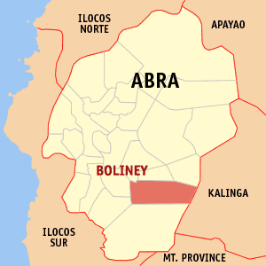
Boliney, officially the Municipality of Boliney, is a 5th class municipality in the province of Abra, Philippines. According to the 2015 census, it has a population of 3,573 people.

Barlig Municipality in Cordillera Administrative Region, Philippines

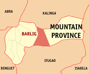
Barlig, officially the Municipality of Barlig is a 5th class municipality in the province of Mountain Province, Philippines. According to the 2015 census, it has a population of 4,819 people.

Natonin Municipality of the Philippines in the Mountain Province

Natonin, officially the Municipality of Natonin is a 4th class municipality in the province of Mountain Province, Philippines. According to the 2015 census, it has a population of 10,272 people.

Paracelis Municipality in Cordillera Administrative Region, Philippines

Paracelis, officially the Municipality of Paracelis is a 2nd class municipality in the province of Mountain Province, Philippines. According to the 2015 census, it has a population of 28,121 people.

Lubuagan Municipality in Cordillera Administrative Region, Philippines

Lubuagan, officially the Municipality of Lubuagan is a 4th class municipality in the province of Kalinga, Philippines. According to the 2015 census, it has a population of 8,733 people.

Pinukpuk, Kalinga Municipality in Cordillera Administrative Region, Philippines

Pinukpuk, officially the Municipality of Pinukpuk is a 1st class municipality in the province of Kalinga, Philippines. According to the 2015 census, it has a population of 32,026 people.

Tabuk, Kalinga Component city in Cordillera Administrative Region, Philippines

Tabuk,, officially the City of Tabuk, or simply referred to as Tabuk City, is a 5th class city and capital of the province of Kalinga, Philippines. According to the 2015 census, it has a population of 110,642 people.

Atok, Benguet Municipality in Cordillera Administrative Region, Philippines

Atok, officially the Municipality of Atok,, is a 4th class municipality in the province of Benguet, Philippines. According to the 2015 census, it has a population of 19,668 people.

Abra (province) Province in Cordillera Administrative Region, Philippines

Abra is a landlocked province of the Philippines in the Cordillera Administrative Region in Luzon. Its capital is Bangued, and is bordered by Ilocos Norte on the northwest, Apayao on the northeast, Kalinga on the mid-east, Mountain Province on the southeast, and Ilocos Sur on the southwest.

Kalinga language Northern Luzon language spoken in the Kalinga province of the Cordilleras

Kalinga is a dialect continuum of Kalinga Province in the Philippines, spoken by the Igorot people, alongside Ilocano. The Banao Itneg variety is not one of the neighboring Itneg languages.

The Legislative District of Mountain Province is the representation of Mountain Province in the various national legislatures of the Philippines. The province is currently represented in the lower house of the Congress of the Philippines through its lone congressional district.

Chico River (Philippines) river in the Philippines

The Chico River, is a river system in the Philippines in the island of Luzon, encompassing the regions of Cordillera and Cagayan Valley. It is the longest tributary of Cagayan River.

Balbalasang–Balbalan National Park national park of the Philippines

Balbalasang–Balbalan National Park is a protected area of the Philippines located in the municipality of Balbalan, Kalinga in the Cordillera Administrative Region. The park covers an area of 1,338 hectares and is centered on Mount Balbalasang in the barangay of the same name near the provincial border with Abra. Dubbed the "green heart of the Cordillera", the park is representative of the rich biodiversity and landscape of this mountain region with some of the most intact pine forests and richly endemic flora and fauna. It was declared a national park in 1972 by virtue of Republic Act No. 6463.

Macli-ing Dulag Filipino environmentalist

Macli-ing Dulag was a pangat (leader) of the Butbut tribe of Kalinga province in the Philippines. He is best known for his opposition to the Chico River Dam Project, which led to his assassination by armed forces under the command of then-President Ferdinand Marcos.

References

  1. "Municipality". Quezon City, Philippines: Department of the Interior and Local Government. Retrieved 31 May 2013.
  2. "Province: Kalinga". PSGC Interactive. Quezon City, Philippines: Philippine Statistics Authority . Retrieved 12 November 2016.
  3. 1 2 3 4 Census of Population (2015). "Cordillera Administrative Region (CAR)". Total Population by Province, City, Municipality and Barangay. PSA . Retrieved 20 June 2016.
  4. "PSA releases the 2015 Municipal and City Level Poverty Estimates". Quezon City, Philippines. Retrieved 12 October 2019.
  5. Scott 1974, 2; Bacdayan 1967, 17; Lawless 1975, 43-45
  6. cf. Scott 1974, 249; Sugguiyao 1990, 15; Bacdayan, 17-18; Dozier 1966, 29-32
  7. Barton 1949, 32; cf. Dozier 1967, 12 f; Sugguiyao, 4.
  8. Sugguiyao, 16
  9. De Los Reyes 1986, 28; Sugguiyao, 22; Jenista, 70,259
  10. "Balbalan: Average Temperatures and Rainfall". Meteoblue. Retrieved 8 March 2020.
  11. Census of Population and Housing (2010). "Cordillera Administrative Region (CAR)". Total Population by Province, City, Municipality and Barangay. NSO . Retrieved 29 June 2016.
  12. Censuses of Population (1903–2007). "Cordillera Administrative Region (CAR)". Table 1. Population Enumerated in Various Censuses by Province/Highly Urbanized City: 1903 to 2007. NSO.
  13. "Province of Kalinga". Municipality Population Data. Local Water Utilities Administration Research Division. Retrieved 17 December 2016.

Works cited

Books
Periodicals