Tanudan | |
---|---|
Municipality of Tanudan | |
Map of Kalinga with Tanudan highlighted | |
Location within the Philippines | |
Coordinates: 17°18′N121°14′E / 17.3°N 121.23°E Coordinates: 17°18′N121°14′E / 17.3°N 121.23°E | |
Country | |
Region | Cordillera Administrative Region (CAR) |
Province | Kalinga |
District | Lone District |
Barangays | 16 (see Barangays) |
Government | |
• Type | Sangguniang Bayan |
• Mayor | Jaedicke Rhoss P. Dagadag |
• Vice Mayor | Joseph B. Cosidon |
• Congressman | Allen Jesse C. Mangaoang |
• Electorate | 9,035 voters (2019) |
Area | |
• Total | 307.55 km2 (118.75 sq mi) |
Elevation | 534.8 m (1,754.6 ft) |
Population (2015 census) [3] | |
• Total | 9,534 |
• Density | 31/km2 (80/sq mi) |
• Households | 1,568 |
Economy | |
• Income class | 4th municipal income class |
• Poverty incidence | 38.55% (2015) [4] |
• Revenue (₱) | 74,086,051.41 (2016) |
Time zone | UTC+8 (PST) |
ZIP code | 3805 |
PSGC | |
IDD : area code | +63 (0)74 |
Climate type | tropical rainforest climate |
Native languages | Kalinga language Balangao Ilocano Tagalog |
Website | www |
Tanudan, officially the Municipality of Tanudan is a 4th class municipality in the province of Kalinga, Philippines. According to the 2015 census, it has a population of 9,534 people. [3]
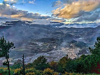
The town is known for Mount Binarbatan. Legend tells that the supreme god of the Kalinga people went into the mountain to hunt but was irritated due to the noises made by the birds, so he ordered the birds to be quiet. When he was done hunting, he forgot to revoke his order from the birds, and thus, the mountain kept silent for all of eternity. [5] Another popular place is the Lubo Village where houses are intact and strategically surrounded with rice terraces. Legend says that a brave warrior challenge god and that no one is stronger than him. So god started building dam that is made of rocks, when the water is high enough, god released the water through a whole called "lubu" that flooded the warrior and his family. The people from Ga-ang and Dacalan gathered together with the remnants of the relatives of the said warrior and saw that the flooded soil was good for planting rice, so they started to cultivating the land and named the village "Lubo".
Tanudan is politically subdivided into 16 barangays. [2]
Climate data for Tanudan, Kalinga | |||||||||||||
---|---|---|---|---|---|---|---|---|---|---|---|---|---|
Month | Jan | Feb | Mar | Apr | May | Jun | Jul | Aug | Sep | Oct | Nov | Dec | Year |
Average high °C (°F) | 23 (73) | 24 (75) | 27 (81) | 29 (84) | 29 (84) | 29 (84) | 28 (82) | 28 (82) | 27 (81) | 26 (79) | 25 (77) | 23 (73) | 27 (80) |
Average low °C (°F) | 18 (64) | 18 (64) | 19 (66) | 20 (68) | 22 (72) | 22 (72) | 22 (72) | 22 (72) | 22 (72) | 21 (70) | 20 (68) | 19 (66) | 20 (69) |
Average precipitation mm (inches) | 78 (3.1) | 60 (2.4) | 49 (1.9) | 51 (2.0) | 194 (7.6) | 197 (7.8) | 209 (8.2) | 226 (8.9) | 185 (7.3) | 180 (7.1) | 143 (5.6) | 183 (7.2) | 1,755 (69.1) |
Average rainy days | 15.6 | 12.5 | 11.8 | 12.5 | 21.0 | 23.3 | 25.2 | 26.1 | 22.6 | 17.1 | 16.7 | 19.6 | 224 |
Source: Meteoblue [6] |
Population census of Tanudan | ||
---|---|---|
Year | Pop. | ±% p.a. |
1939 | 3,720 | — |
1948 | 3,849 | +0.38% |
1960 | 4,607 | +1.51% |
1970 | 5,696 | +2.14% |
1975 | 5,914 | +0.76% |
1980 | 6,327 | +1.36% |
1990 | 9,323 | +3.95% |
1995 | 11,243 | +3.57% |
2000 | 10,275 | −1.91% |
2007 | 8,119 | −3.20% |
2010 | 8,529 | +1.81% |
2015 | 9,534 | +2.14% |
Source: Philippine Statistics Authority [3] [7] [8] [9] |
In the 2015 census, the population of Tanudan, Kalinga, was 9,534 people, [3] with a density of 31 inhabitants per square kilometre or 80 inhabitants per square mile.
Kalinga is a landlocked province in the Philippines situated within the Cordillera Administrative Region in Luzon. Its capital is Tabuk and borders Mountain Province to the south, Abra to the west, Isabela to the east, Cagayan to the northeast, and Apayao to the north. Kalinga and Apayao are the result of the 1995 partitioning of the former province of Kalinga-Apayao which was seen to better service the respective needs of the various indigenous peoples in the area.
Bauko, officially the Municipality of Bauko is a 4th class municipality in the province of Mountain Province, Philippines. According to the 2015 census, it has a population of 31,065 people.
Boliney, officially the Municipality of Boliney, is a 5th class municipality in the province of Abra, Philippines. According to the 2015 census, it has a population of 3,573 people.
Tubo, officially the Municipality of Tubo,, is a 4th class municipality in the province of Abra, Philippines. According to the 2015 census, it has a population of 5,699 people.
Besao, officially the Municipality of Besao is a 5th class municipality in the province of Mountain Province, Philippines. According to the 2015 census, it has a population of 7,040 people.
Natonin, officially the Municipality of Natonin is a 4th class municipality in the province of Mountain Province, Philippines. According to the 2015 census, it has a population of 10,272 people.
Paracelis, officially the Municipality of Paracelis is a 2nd class municipality in the province of Mountain Province, Philippines. According to the 2015 census, it has a population of 28,121 people.
Sabangan, officially the Municipality of Sabangan is a 5th class municipality in the province of Mountain Province, Philippines. According to the 2015 census, it has a population of 9,315 people.
Sadanga, officially the Municipality of Sadanga is a 5th class municipality in the province of Mountain Province, Philippines. According to the 2015 census, it has a population of 8,799 people. Sadanga boundaries both provinces are Abra to the northwest & west and Kalinga to the north & northeast.
Tadian, officially the Municipality of Tadian is a 4th class municipality in the province of Mountain Province, Philippines. According to the 2015 census, it has a population of 19,389 people.
Balbalan, officially the Municipality of Balbalan is a 3rd class municipality in the province of Kalinga, Philippines. According to the 2015 census, it has a population of 12,195 people.
Pasil, officially the Municipality of Pasil is a 5th class municipality in the province of Kalinga, Philippines. According to the 2015 census, it has a population of 9,644 people.
Pinukpuk, officially the Municipality of Pinukpuk is a 1st class municipality in the province of Kalinga, Philippines. According to the 2015 census, it has a population of 32,026 people.
Rizal, officially the Municipality of Rizal is a 4th class municipality in the province of Kalinga, Philippines. According to the 2015 census, it has a population of 17,038 people.
Tabuk,, officially the City of Tabuk, or simply referred to as Tabuk City, is a 5th class city and capital of the province of Kalinga, Philippines. According to the 2015 census, it has a population of 110,642 people.
Tinglayan, officially the Municipality of Tinglayan is a 4th class municipality in the province of Kalinga, Philippines. According to the 2015 census, it has a population of 12,868 people.
Bakun, officially the Municipality of Bakun,, is a 3rd class municipality in the province of Benguet, Philippines. According to the 2015 census, it has a population of 15,357 people.
Kibungan, officially the Municipality of Kibungan,, is a 4th class municipality in the province of Benguet, Philippines. According to the 2015 census, it has a population of 17,292 people.
Hungduan, officially the Municipality of Hungduan is a 4th class municipality in the province of Ifugao, Philippines. According to the 2015 census, it has a population of 9,400 people.
Tinoc, officially the Municipality of Tinoc is a 4th class municipality in the province of Ifugao, Philippines. According to the 2015 census, it has a population of 16,559 people.
This article about a location in the Cordillera Administrative Region is a stub. You can help Wikipedia by expanding it. |