Tinglayan, Kalinga

Last updated
Tinglayan
Municipality of Tinglayan
Tinglayan80427cg.jpg
Ph locator kalinga tinglayan.png
Map of Kalinga with Tinglayan highlighted
Tinglayan, Kalinga
Philippines location map (square).svg
Red pog.svg
Tinglayan
Location within the Philippines
Coordinates: 17°17′N121°10′E / 17.28°N 121.17°E / 17.28; 121.17 Coordinates: 17°17′N121°10′E / 17.28°N 121.17°E / 17.28; 121.17
Country Flag of the Philippines.svg  Philippines
Region Cordillera Administrative Region (CAR)
Province Kalinga
District Lone District of Kalinga
Barangays 20 (see Barangays)
Government
[1]
  Type Sangguniang Bayan
   Mayor Sacrament S. Gumilab
   Vice Mayor Charles A. Abay
  CongressmanAllen Jesse C. Mangaoang
  Electorate9,233 voters (2019)
Area
[2]
  Total283.00 km2 (109.27 sq mi)
Elevation
505.2 m (1,657.5 ft)
Population
 (2015 census) [3]
  Total12,868
  Density45/km2 (120/sq mi)
  Households
2,270
Economy
   Income class 4th municipal income class
   Poverty incidence 30.53% (2015) [4]
  Revenue (₱)76,712,123.36 (2016)
Time zone UTC+8 (PST)
ZIP code
3804
PSGC
IDD : area code +63(0)74
Climate type tropical rainforest climate
Native languagesKalinga language
Ilocano
Tagalog
Website https://tinglayan.gov.ph

Tinglayan, officially the Municipality of Tinglayan is a 4th class municipality in the province of Kalinga, Philippines. According to the 2015 census, it has a population of 12,868 people. [3]

Contents

Barangays

Tinglayan is politically subdivided into 20 barangays. [2]

Climate

Climate data for Tinglayan, Kalinga
MonthJanFebMarAprMayJunJulAugSepOctNovDecYear
Average high °C (°F)25
(77)
26
(79)
28
(82)
30
(86)
29
(84)
29
(84)
28
(82)
28
(82)
28
(82)
27
(81)
26
(79)
25
(77)
27
(81)
Average low °C (°F)17
(63)
18
(64)
19
(66)
21
(70)
22
(72)
23
(73)
22
(72)
22
(72)
22
(72)
20
(68)
20
(68)
19
(66)
20
(69)
Average precipitation mm (inches)23
(0.9)
28
(1.1)
33
(1.3)
64
(2.5)
232
(9.1)
242
(9.5)
258
(10.2)
266
(10.5)
245
(9.6)
201
(7.9)
87
(3.4)
69
(2.7)
1,748
(68.7)
Average rainy days8.38.010.815.223.726.127.025.823.517.313.712.1211.5
Source: Meteoblue [5]

Demographics

Population census of Tinglayan
YearPop.±% p.a.
1918 2,879    
1939 6,868+4.23%
1948 6,935+0.11%
1960 9,135+2.32%
1970 10,317+1.22%
1975 10,838+0.99%
1980 11,703+1.55%
1990 12,637+0.77%
1995 13,591+1.37%
2000 14,164+0.89%
2007 11,619−2.69%
2010 12,557+2.87%
2015 12,868+0.47%
Source: Philippine Statistics Authority [3] [6] [7] [8]


In the 2015 census, the population of Tinglayan was 12,868 people, [3] with a density of 45 inhabitants per square kilometre or 120 inhabitants per square mile.

Tourism

Sleeping Beauty mountain SleepingBeauty2180.jpg
Sleeping Beauty mountain

Tinglayan is famous for its local celebrity, Whang-od, who is the last mambabatok (traditional tattooist). Tourists often visit Tinglayan to see her and have their bodies tattooed. [9]

Related Research Articles

Luna, Apayao Municipality in Cordillera Administrative Region, Philippines

Luna, officially the Municipality of Luna,, is a 2nd class municipality in the province of Apayao, Philippines. According to the 2015 census, it has a population of 19,063 people.

Bucloc Municipality in Cordillera Administrative Region, Philippines

Bucloc, officially the Municipality of Bucloc, is a 6th class municipality in the province of Abra, Philippines. According to the 2015 census, it has a population of 2,501 people.

Daguioman Municipality in Cordillera Administrative Region, Philippines

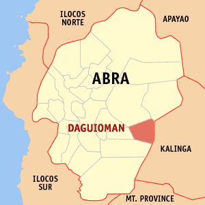
Daguioman, officially the Municipality of Daguioman, is a 5th class municipality in the province of Abra, Philippines. According to the 2015 census, it had a population of 2,088 people.

Lagangilang Municipality in Cordillera Administrative Region, Philippines

Lagangilang, officially the Municipality of Lagangilang, is a 5th class municipality in the province of Abra, Philippines. According to the 2015 census, it has a population of 14,255 people.

Lagayan Municipality in Cordillera Administrative Region, Philippines

Lagayan, officially the Municipality of Lagayan, is a 5th class municipality in the province of Abra, Philippines. According to the 2015 census, it has a population of 4,499 people.

Boliney Municipality in Cordillera Administrative Region, Philippines

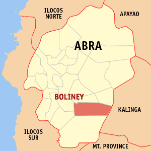
Boliney, officially the Municipality of Boliney, is a 5th class municipality in the province of Abra, Philippines. According to the 2015 census, it has a population of 3,573 people.

Malibcong Municipality in Cordillera Administrative Region, Philippines

Malibcong, officially the Municipality of Malibcong, is a 5th class municipality in the province of Abra, Philippines. According to the 2015 census, it has a population of 3,428 people.

Pidigan Municipality in Cordillera Administrative Region, Philippines

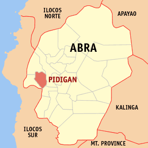
Pidigan, officially the Municipality of Pidigan,, is a 5th class municipality in the province of Abra, Philippines. According to the 2015 census, it has a population of 12,185 people.

San Quintin, Abra Municipality in Cordillera Administrative Region, Philippines

San Quintin, officially the Municipality of San Quintin,, is a 5th class municipality in the province of Abra, Philippines. According to the 2015 census, it has a population of 5,438 people.

Tubo, Abra Municipality in Cordillera Administrative Region, Philippines

Tubo, officially the Municipality of Tubo,, is a 4th class municipality in the province of Abra, Philippines. According to the 2015 census, it has a population of 5,699 people.

Barlig Municipality in Cordillera Administrative Region, Philippines

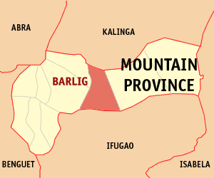
Barlig, officially the Municipality of Barlig is a 5th class municipality in the province of Mountain Province, Philippines. According to the 2015 census, it has a population of 4,819 people.

Kabugao Municipality in Cordillera Administrative Region, Philippines

Kabugao, officially the Municipality of Kabugao,, is a 1st class municipality and capital of the province of Apayao, Philippines. According to the 2015 census, it has a population of 15,537 people.

Balbalan, Kalinga Municipality in Cordillera Administrative Region, Philippines

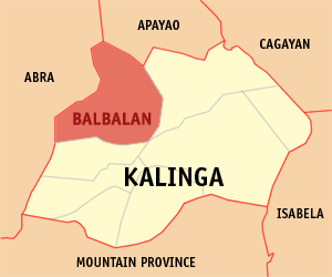
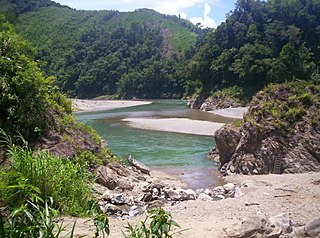
Balbalan, officially the Municipality of Balbalan is a 3rd class municipality in the province of Kalinga, Philippines. According to the 2015 census, it has a population of 12,195 people.

Lubuagan Municipality in Cordillera Administrative Region, Philippines

Lubuagan, officially the Municipality of Lubuagan is a 4th class municipality in the province of Kalinga, Philippines. According to the 2015 census, it has a population of 8,733 people.

Pasil, Kalinga Municipality in Cordillera Administrative Region, Philippines

Pasil, officially the Municipality of Pasil is a 5th class municipality in the province of Kalinga, Philippines. According to the 2015 census, it has a population of 9,644 people.

Rizal, Kalinga Municipality in Cordillera Administrative Region, Philippines

Rizal, officially the Municipality of Rizal is a 4th class municipality in the province of Kalinga, Philippines. According to the 2015 census, it has a population of 17,038 people.

Tabuk, Kalinga Component city in Cordillera Administrative Region, Philippines

Tabuk,, officially the City of Tabuk, or simply referred to as Tabuk City, is a 5th class city and capital of the province of Kalinga, Philippines. According to the 2015 census, it has a population of 110,642 people.

Tanudan, Kalinga Municipality in Cordillera Administrative Region, Philippines

Tanudan, officially the Municipality of Tanudan is a 4th class municipality in the province of Kalinga, Philippines. According to the 2015 census, it has a population of 9,534 people.

Hungduan, Ifugao Municipality in Cordillera Administrative Region, Philippines

Hungduan, officially the Municipality of Hungduan is a 4th class municipality in the province of Ifugao, Philippines. According to the 2015 census, it has a population of 9,400 people.

Lagawe, Ifugao Municipality in Cordillera Administrative Region, Philippines

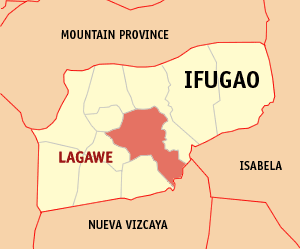
Lagawe, officially the Municipality of Lagawe is a 4th class municipality and capital of the province of Ifugao, Philippines. According to the 2015 census, it has a population of 19,333 people.

References

  1. "Municipality". Quezon City, Philippines: Department of the Interior and Local Government. Retrieved 31 May 2013.
  2. 1 2 "Province: Kalinga". PSGC Interactive. Quezon City, Philippines: Philippine Statistics Authority . Retrieved 12 November 2016.
  3. 1 2 3 4 Census of Population (2015). "Cordillera Administrative Region (CAR)". Total Population by Province, City, Municipality and Barangay. PSA . Retrieved 20 June 2016.
  4. "PSA releases the 2015 Municipal and City Level Poverty Estimates". Quezon City, Philippines. Retrieved 12 October 2019.
  5. "Tinglayan: Average Temperatures and Rainfall". Meteoblue. Retrieved 8 March 2020.
  6. Census of Population and Housing (2010). "Cordillera Administrative Region (CAR)". Total Population by Province, City, Municipality and Barangay. NSO . Retrieved 29 June 2016.
  7. Censuses of Population (1903–2007). "Cordillera Administrative Region (CAR)". Table 1. Population Enumerated in Various Censuses by Province/Highly Urbanized City: 1903 to 2007. NSO.
  8. "Province of Kalinga". Municipality Population Data. Local Water Utilities Administration Research Division. Retrieved 17 December 2016.
  9. "The lost tribe and the 'tattoo master'". news.com.au . Australia. 27 May 2015. Retrieved 19 October 2015.