
Sullivan County is a county in the Commonwealth of Pennsylvania. As of the 2020 census, the population was 5,840, making it the second-least populous county in Pennsylvania. Its county seat is Laporte. The county was created on March 15, 1847, from part of Lycoming County and named for Major General John Sullivan. The county is part of the Northeast Pennsylvania region of the state.

Worlds End State Park is a 780-acre (316 ha) Pennsylvania state park in Sullivan County, Pennsylvania. The park, nearly surrounded by Loyalsock State Forest, is in the Loyalsock Creek valley on Pennsylvania Route 154 in Forks and Shrewsbury Townships southeast of the borough of Forksville. The name Worlds End has been used since at least 1872, but its origins are uncertain. Although it was founded as Worlds End State Forest Park by Governor Gifford Pinchot in 1932, the park was officially known as Whirls End State Forest Park from 1936 to 1943.

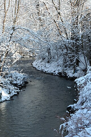
Loyalsock Creek is a 64-mile-long (103 km) tributary of the West Branch Susquehanna River located chiefly in Sullivan and Lycoming counties in Pennsylvania in the United States. As the crow flies, Lycoming County is about 130 miles (209 km) northwest of Philadelphia and 165 miles (266 km) east-northeast of Pittsburgh.

Wiconisco Creek is a tributary of the Susquehanna River in Schuylkill and Dauphin counties, Pennsylvania, in the United States. It is approximately 45.5 miles (73.2 km) long.

Little Pine State Park is a Pennsylvania state park on 2,158 acres (873 ha) in Cummings Township, Lycoming County, Pennsylvania in the United States. Little Pine State park is along 4.2 miles (6.8 km) of Little Pine Creek, a tributary of Pine Creek, in the midst of the Tiadaghton State Forest. A dam on the creek has created a lake covering 94 acres (38 ha) for fishing, boating, and swimming. The park is on Pennsylvania Route 4001, 4 miles (6.4 km) northeast of the unincorporated village of Waterville or 8 miles (13 km) southwest of the village of English Center. The nearest borough is Jersey Shore, Pennsylvania, about 15 miles (24 km) south at the mouth of Pine Creek on the West Branch Susquehanna River.
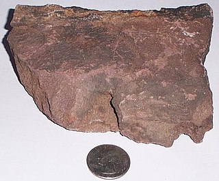
The Silurian Bloomsburg Formation is a mapped bedrock unit in Pennsylvania, New Jersey, New York and Maryland. It is named for the town of Bloomsburg, Pennsylvania, in which it was first described. The Bloomsburg marked the first occurrence of red sedimentary rocks in the Appalachian Basin.

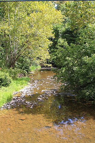
Plunketts Creek is an approximately 6.2-mile-long (10 km) tributary of Loyalsock Creek in Lycoming and Sullivan counties in the U.S. state of Pennsylvania. Two unincorporated villages and a hamlet are on the creek, and its watershed drains 23.6 square miles (61 km2) in parts of five townships. The creek is a part of the Chesapeake Bay drainage basin via Loyalsock Creek and the West Branch Susquehanna and Susquehanna Rivers.

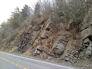
The Mississippian Pocono Formation is a mapped bedrock unit in Pennsylvania, Maryland, and West Virginia, in the United States. It is also known as the Pocono Group in Maryland and West Virginia, and the upper part of the Pocono Formation is sometimes called the Burgoon Formation or Burgoon Sandstone in Pennsylvania. The Pocono is a major ridge-former In the Ridge-and-Valley Appalachians of the eastern United States

The Lock Haven Formation is a Devonian mapped bedrock unit in Pennsylvania, in the Appalachian Mountains of the United States.

Broad Top is a plateau located in south-central Pennsylvania. It extends into Huntingdon County to the north, Fulton County to the southeast, and Bedford County to the southwest. It is bounded to the west by Saxton Mountain and Terrace Mountain, and to the east by Sideling Hill. In Bedford County, Harbor Mountain forms the southern boundary. Trough Creek Valley lies between the mountains.
The Devonian Old Port Formation is a mapped bedrock unit in Pennsylvania, USA. Details of the type section and of stratigraphic nomenclature for this unit as used by the U.S. Geological Survey are available on-line at the National Geologic Map Database. Current nomenclature usage by U.S. Geological Survey restricts the name Old Port Formation to Pennsylvania, but correlative units are present in adjacent states.

There are 24 named waterfalls in Ricketts Glen State Park in the U.S. state of Pennsylvania along Kitchen Creek as it flows in three steep, narrow valleys, or glens. They range in height from 9 feet (2.7 m) to the 94-foot (29 m) Ganoga Falls. Ricketts Glen State Park is named for R. Bruce Ricketts, a colonel in the American Civil War who owned over 80,000 acres in the area in the late 19th and early 20th centuries, but spared the old-growth forests in the glens from clearcutting. The park, which opened in 1944, is administered by the Bureau of State Parks of the Pennsylvania Department of Conservation and Natural Resources (DCNR). Nearly all of the waterfalls are visible from the Falls Trail, which Ricketts had built from 1889 to 1893 and which the state park rebuilt in the 1940s and late 1990s. The Falls Trail has been called "the most magnificent hike in the state" and one of "the top hikes in the East".
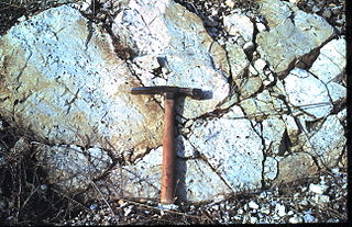
The Late Silurian to Early Devonian Keyser Formation is a mapped limestone bedrock unit in Pennsylvania, Maryland, Virginia, and West Virginia.

The Rockwell Formation is a late Devonian and early Mississippian mapped bedrock unit in West Virginia, Maryland, and Pennsylvania, in the United States.
Little Shamokin Creek is a 15.0-mile-long (24.1 km) tributary of Shamokin Creek and a sub-tributary of the Susquehanna River in Northumberland County, Pennsylvania, in the United States. The watershed of the creek has an area of 37 square miles, spread out over Upper Augusta Township, Lower Augusta Township, Rockefeller Township, and Shamokin Township. The creek's watershed contains four rock formations. These are the Hamilton Group, the Spechty Kopf formation, the Irish Valley formation, and the Buddy Run formation. The watershed also contains three main soil types. They are the Berks-Weikert-Bedington series, the Leck Kill-Meckesville-Calvin series and the Hazelton-Dekalb-Buchanan series.
Solomon Creek is a tributary of the Susquehanna River in Luzerne County, Pennsylvania, in the United States. It is approximately 8.8 miles (14.2 km) long and flows through Fairview Township, Hanover Township, and Wilkes-Barre. The creek is affected by acid mine drainage and has significant loads of iron, aluminum, and manganese. The creek's named tributaries are Spring Run, Sugar Notch Run, and Pine Creek. The Solomon Creek watershed is located in the Anthracite Valley section of the ridge-and-valley geographical province. Major rock formations in the watershed include the Mauch Chunk Formation, the Spechty Kopf Formation, and the Catskill Formation.
Mine Gap Run is a tributary of Catawissa Creek in Columbia County, Pennsylvania, in the United States. It is approximately 1.5 miles (2.4 km) long and flows through Roaring Creek Township and Beaver Township. The watershed of the stream has an area of 0.92 square miles (2.4 km2). The stream is polluted and acidic. However, it is considered to be a coldwater fishery. The main rock formations in the stream's watershed are the Mauch Chunk Formation, the Spechty Kopf Formation, the Pocono Formation, and the Buddys Run Member of the Catskill Formation.

Long Hollow is a tributary of Catawissa Creek in Columbia County, Pennsylvania, in the United States. It is approximately 2.5 miles (4.0 km) long and flows through Roaring Creek Township and Beaver Township. The watershed of the stream has an area of 2.84 square miles (7.4 km2). The stream has a neutral pH and is considered to be a coldwater fishery. The main rock formations in the stream's watershed are the Mauch Chunk Formation, the Spechty Kopf Formation, the Pocono Formation, and the Buddys Run Member of the Catskill Formation.

Nescopeck Mountain is a ridge in Columbia County and Luzerne County, in Pennsylvania, in the United States. Its elevation is 1,594 feet (486 m) above sea level. The ridge is a forested ridge, with at least two types of forest and two systems of vernal pools. It is a very long and unbroken ridge with two water gaps: one carved by Catawissa Creek and one carved by Nescopeck Creek. This later gap was exploited as a transportation corridor with the construction of the Lausanne–Nescopeck Turnpike between the respective frontier communities at Lausanne Landing and Nescopeck in 1805 connecting the newly developing Wyoming Valley with Philadelphia and the Delaware River valley; cutting off over 100 miles between Philadelphia and Wilkes-Barre. Today's Route PA 93 derives from this historic pack mule road.

Central Mountain is a mountain in Columbia County, Sullivan County, and Luzerne County, in Pennsylvania, United States. Its elevation is 2,247 feet (685 m) above sea level. The mountain is part of the Allegheny Front. Rock formations on the mountain include the Pocono Formation and the Duncannon Member of the Catskill Formation. It was historically known as North Mountain, but it was renamed Central Mountain in the late 1800s. The mountain is one of the most important sites on the Columbia County Natural Areas Inventory and it is inhabited by dozens of trees, shrubs, and herbaceous plants. Numerous birds and several amphibians and mammals are also found in the area.

