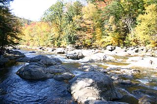
Scherr is an unincorporated community in Grant County, West Virginia, United States. The community's name is pronounced like "sheer." Scherr lies to the west of the community of Greenland at the crossroads of West Virginia Route 42, West Virginia Route 93, and U.S. Route 48. Scherr is home to a rock quarry, asphalt plant, and a small country store.
The Silurian Bloomsburg Formation is a mapped bedrock unit in Pennsylvania, New Jersey, New York and Maryland. It is named for the town of Bloomsburg, Pennsylvania, in which it was first described. The Bloomsburg marked the first occurrence of red sedimentary rocks in the Appalachian Basin.

The Silurian Tuscarora Formation — also known as Tuscarora Sandstone or Tuscarora Quartzite — is a mapped bedrock unit in Pennsylvania, Maryland, West Virginia, and Virginia, US.

The Ordovician Juniata Formation is a mapped bedrock unit in Pennsylvania, West Virginia, Virginia, Tennessee, and Maryland. It is a relative slope-former occurring between the two prominent ridge-forming sandstone units: the Tuscarora Formation and the Bald Eagle Formation in the Appalachian Mountains.

The Hamilton Group is a Devonian-age geological group which is located in the Appalachian region of the United States. It is present in New York, Pennsylvania, Maryland, Ohio, West Virginia, northwestern Virginia and Ontario, Canada, and is mainly composed of marine shale with some sandstone.
The Devonian Mahantango Formation is a mapped bedrock unit in Pennsylvania, West Virginia, and Maryland. It is named for the North branch of the Mahantango Creek in Perry and Juniata counties in Pennsylvania. It is a member of the Hamilton Group, along with the underlying the Marcellus Formation Shale. South of Tuscarora Mountain in south central Pennsylvania, the lower members of this unit were also mapped as the Montebello Formation. Details of the type section and of stratigraphic nomenclature for this unit as used by the U.S. Geological Survey are available on-line at the National Geologic Map Database.

The Marcellus Formation or the Marcellus Shale is a Middle Devonian age unit of sedimentary rock found in eastern North America. Named for a distinctive outcrop near the village of Marcellus, New York, in the United States, it extends throughout much of the Appalachian Basin.
The Huntley Mountain Formation is a late Devonian and early Mississippian mapped bedrock unit in Pennsylvania, in the United States.

The Lock Haven Formation is a Devonian mapped bedrock unit in Pennsylvania, in the Appalachian Mountains of the United States.

The Bedford Shale is a shale geologic formation in the states of Ohio, Michigan, Pennsylvania, Kentucky, West Virginia, and Virginia in the United States.
The Devonian Old Port Formation is a mapped bedrock unit in Pennsylvania, USA. Details of the type section and of stratigraphic nomenclature for this unit as used by the U.S. Geological Survey are available on-line at the National Geologic Map Database. Current nomenclature usage by U.S. Geological Survey restricts the name Old Port Formation to Pennsylvania, but correlative units are present in adjacent states.
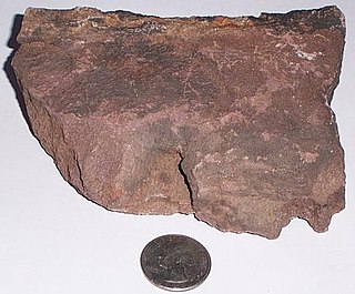
The Devonian Scherr Formation is a mapped bedrock unit in Pennsylvania, Maryland, Virginia and West Virginia.

The Devonian Foreknobs Formation is a mapped bedrock unit in Pennsylvania, Maryland, Virginia, and West Virginia.

The Rockwell Formation is a late Devonian and early Mississippian mapped bedrock unit in West Virginia, Maryland, and Pennsylvania, in the United States.
The Cambrian Warrior Formation is a mapped limestone bedrock unit in Pennsylvania.
The Devonian Harrell Formation is a mapped bedrock unit in Pennsylvania, Maryland, West Virginia, and Virginia.
The Ridgeley sandstone is a sandstone or quartzite of Devonian age found in the Appalachian Mountains of Pennsylvania, Maryland, West Virginia, and Virginia, United States. The Ridgeley is fine-grained, siliceous, calcareous in its lower strata, sometimes fossiliferous, and sometimes locally pebbly or conglomeritic. Varying in thickness from 12 to 500 feet, this rock slowly erodes into white quartz sand that often washes or blows away, but sometimes accumulates at large outcrops. When freshly broken, the rock is white, but outcrop surfaces are often stained yellowish by iron oxides.
The Waynesboro Formation is a limestone, dolomite, and sandstone geologic formation in Virginia, Maryland, Pennsylvania and West Virginia. In some areas it is composed of limestone and dolomite. The Waynsboro Formation is one of the formations that make up the Shenandoah Valley. It dates back to the Cambrian period and is not considered fossiliferous.
The Huntersville Chert or Huntersville Formation is a Devonian geologic formation in the Appalachian region of the United States. It is primarily composed of mottled white, yellow, and dark grey chert, and is separated from the underlying Oriskany Sandstone by an unconformity. The Huntersville Chert is laterally equivalent to the Needmore Shale, which lies north of the New River. It is also laterally equivalent to a sandy limestone unit which is often equated with the Onondaga Limestone. to the west and the Needmore Shale to the east. These formations are placed in the Onesquethaw Stage of Appalachian chronostratigraphy, roughly equivalent to the Emsian and Eifelian stages of the broader Devonian system.
The Burket Shale or Geneseo Shale is the lowest member of the Harrell Shale/Genessee Group.


