
The 2004 Pacific hurricane season was unusual in that no tropical cyclones of at least tropical storm intensity made landfall, the first such occurrence since 1991. The season was also below-average in terms of named storms and hurricanes, near-average in terms of major hurricanes. The season officially began on May 15 in the eastern Pacific, and on June 1 in the central Pacific; it officially ended in both basins on November 30. These dates conventionally delimit the period during each year when a majority of tropical cyclones form. The season was reflected by an accumulated cyclone energy (ACE) index of 71 units.

The 2005 Pacific hurricane season was a near-average season which produced fifteen named storms, only seven hurricanes formed and two major hurricanes. It was also the second consecutive season in which no tropical cyclone of at least tropical storm intensity made landfall. The season officially began on May 15 in the East Pacific Ocean, and on June 1 in the Central Pacific; they ended on November 30. These dates conventionally delimit the period of each year when most tropical cyclones form in the Pacific basin. However, the formation of tropical cyclones is possible at any time of the year.

The 2003 Pacific hurricane season was the first season to feature no major hurricanes – storms of Category 3 intensity or higher on the Saffir–Simpson hurricane wind scale (SSHWS) – since 1977. The dates conventionally delimiting the period when most tropical cyclones form in the Pacific Ocean are May 15 in the Eastern Pacific Ocean and June 1 in the Central Pacific, with both seasons ending on November 30. The 2003 season featured 16 tropical storms between May 19 and October 26; 7 of these became hurricanes, which was then considered an average season. Damage across the basin reached US$129 million, and 23 people were killed by the storms.
The 2002 Pacific hurricane season was an above-average season which produced fifteen named storms. Eight hurricanes formed, including three Category 5 hurricanes, which tied for the most in a season with 1994 and 2018. Moreover, the season was a near-average season in terms of accumulated cyclone energy (ACE), with a total index of 125 units. The season officially began on May 15 in the East Pacific Ocean, and on June 1 in the Central Pacific and they both ended on November 30. These dates conventionally delimit the period of each year when most tropical cyclones form in the Pacific basin. However, the formation of tropical cyclones is possible at any time of the year.

The 2000 Pacific hurricane season was an above-average Pacific hurricane season, although most of the storms were weak and short-lived. There were few notable storms this year. Tropical storms Miriam, Norman, and Rosa all made landfall in Mexico with minimal impact. Hurricane Daniel briefly threatened the U.S. state of Hawaii while weakening. Hurricane Carlotta was the strongest storm of the year and the second-strongest June hurricane in recorded history. Carlotta killed 18 people when it sank a freighter. Overall, the season was significantly more active than the previous season, with 19 tropical storms. In addition, six hurricanes developed. Furthermore, there were total of two major hurricanes.

The 1997 Pacific hurricane season was a very active hurricane season. With hundreds of deaths and hundreds of millions of dollars in damage, this season was one of the costliest and deadliest Pacific hurricane seasons. This was due to the exceptionally strong 1997–98 El Niño event. The season officially started on May 15, in the eastern Pacific, and on June 1, in the central Pacific, and lasted until November 30. These dates conventionally delimit the period of each year when almost all tropical cyclones form in the northeastern Pacific Ocean.
The 1985 Pacific hurricane season is the third-most active Pacific hurricane season on record. It officially started on May 15, 1985, in the eastern Pacific, and on June 1, 1985, in the central Pacific, and lasted until November 30, 1985. These dates conventionally delimit the period of each year when most tropical cyclones form in the northeastern Pacific Ocean. At the time, the 1985 season was the most active on record in the eastern north Pacific, with 28 tropical cyclones forming. Of those, 24 were named, 13 reached hurricane intensity, and 8 became major hurricanes by attaining Category 3 status or higher on the Saffir–Simpson scale. At that time, the 24 named storms was a record; however, this record was broken seven years later in 1992, and was therefore recognized as the second busiest season within the basin, until it was surpassed exactly thirty years later by the 2015 season.

The 2007 Pacific hurricane season was a below-average Pacific hurricane season, featuring one major hurricane. The season officially started on May 15 in the eastern Pacific and on June 1 in the central Pacific, and ended on November 30; these dates conventionally delimit the period during which most tropical cyclones form in the region. The first tropical cyclone of the season, Alvin, developed on May 27, while the final system of the year, Kiko, dissipated on October 23. Due to unusually strong wind shear, activity fell short of the long-term average, with a total of 11 named storms, 4 hurricanes, and 1 major hurricane. At the time, 2007 featured the second-lowest value of the Accumulated cyclone energy (ACE) index since reliable records began in 1971. Two tropical cyclones – Cosme and Flossie – crossed into the central Pacific basin during the year, activity below the average of 4 to 5 systems.

The 2008 Pacific hurricane season was a near-average Pacific hurricane season which featured seventeen named storms, though most were rather weak and short-lived. Only seven hurricanes formed and two major hurricanes. This season was also the first since 1996 to have no cyclones cross into the central Pacific. The season officially began on May 15 in the eastern Pacific and on June 1 in the central Pacific. It ended in both regions on November 30. These dates, adopted by convention, historically describe the period in each year when most tropical cyclone formation occurs in these regions of the Pacific. This season, the first system, Tropical Storm Alma, formed on May 29, and the last, Tropical Storm Polo, dissipated on November 5.
Hurricane Daniel was the second strongest hurricane of the 2006 Pacific hurricane season. The storm affected Hawaii late in its lifetime, causing moderate rainfall and minor damage. The fourth named storm, third hurricane, and second major hurricane of the season, Daniel originated on July 16 from a tropical wave off the coast of Mexico. It tracked westward, intensifying steadily to reach peak winds of 150 mph (240 km/h) on July 22. At the time, the characteristics of the cyclone resembled those of an annular hurricane. Daniel gradually weakened as it entered an area of cooler water temperatures and increased wind shear, and after crossing into the Central Pacific Ocean, it quickly degenerated into a remnant low on July 26, before dissipating two days later.
Hurricane Flossie was a powerful Pacific tropical cyclone that brought squally weather and light damage to Hawaii in August 2007. The sixth named storm, second hurricane, first and only major hurricane of the inactive 2007 Pacific hurricane season, Flossie originated from a tropical wave that emerged off Africa on July 21. After traversing the tropical Atlantic, the wave crossed Central America and entered the eastern Pacific on August 1. There, a favorable environment allowed it to become a tropical depression and a tropical storm shortly thereafter on August 8.
Hurricane Kenneth was the strongest and longest-tracked hurricane of the 2005 Pacific hurricane season. The eleventh named storm and fifth hurricane of the season, Kenneth developed from a disturbance in the Intertropical Convergence Zone to the southwest of Mexico on September 14. It quickly attained peak winds of 135 mph (217 km/h) on September 18, before weakening due to increased wind shear and turning to a southwest drift. After weakening to tropical storm status, Kenneth attained a steady west-northwest motion and encountered favorable enough conditions for it to gain power and attain hurricane status on September 25. The cyclone again weakened as its motion halted, and on September 30 Kenneth dissipated a short distance off the Big Island of Hawaii. The remnants of Kenneth produced one of the highest rainfall totals in Hawaii, reaching up to 12 inches (300 mm) on Oahu. The rainfall caused flooding, though no major damage was reported.

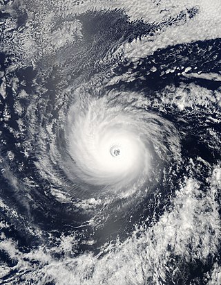
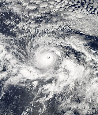
Hurricane Emilia was, at the time, the strongest tropical cyclone on record in the Central Pacific Ocean, and the second of such to be classified as a Category 5 hurricane – the highest rating on the Saffir–Simpson hurricane wind scale. However, hurricanes Gilma later that year, Ioke in 2006, and hurricanes Lane and Walaka in 2018 later reached lower barometric pressures in the Central Pacific. In addition, Emilia was the first Category 5 Pacific hurricane since Hurricane Ava in 1973. The fifth named storm and the first of three Category 5 hurricanes of the 1994 hurricane season, Emilia developed from an area of low pressure southeast of Hawaii on July 16. Tracking westward, the initial tropical depression intensified into a tropical storm several hours after tropical cyclogenesis. Subsequently, Emilia entered the Central Pacific Ocean and moved into the area of responsibility of the Central Pacific Hurricane Center (CPHC).

Hurricane Cosme was a minimal hurricane that threatened Hawaii in mid-July 2007. The sixth tropical cyclone, third named storm and first hurricane of the 2007 Pacific hurricane season, Cosme originated from a tropical wave that emerged off the coast of Africa on June 27 and tracked westward before emerging in the eastern Pacific. A system along the wave organized, and it was classified as a tropical depression on July 14, a tropical storm on July 15, and a hurricane on July 16. Cosme reached peak intensity as a Category 1 hurricane on the Saffir-Simpson Hurricane Scale, but quickly weakened due to cooler waters. Steadily decreasing in strength, the storm was downgraded to a tropical depression before passing to the south of the Hawaiian Islands. The depression crossed into the Central Pacific and degenerated into a remnant low by July 23.

The 2006 Pacific hurricane season was the first above-average season since 1994 which produced twenty-five tropical cyclones, with nineteen named storms, though most were rather weak and short-lived. Only eleven hurricanes formed and six major hurricanes. Following the inactivity of the previous seasons, forecasters predicted that season would be only slightly above active. It was also the first time since 2003 in which at least one cyclone of tropical storm intensity made landfall. The season officially began on May 15 in the East Pacific Ocean, and on June 1 in the Central Pacific; they ended on November 30. These dates conventionally delimit the period of each year when most tropical cyclones form in the Pacific basin. However, the formation of tropical cyclones is possible at any time of the year.

The 2009 Pacific hurricane season was the most active Pacific hurricane season since 1994. The season officially started on May 15 in the East Pacific Ocean, and on June 1 in the Central Pacific; they both ended on November 30. These dates conventionally delimit the period of each year when most tropical cyclones form in the Pacific basin. The first tropical cyclone to form was One-E on June 18, and the last, Hurricane Neki, dissipated on October 27.
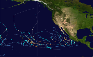
The 2015 Pacific hurricane season is the second-most active Pacific hurricane season on record, with 26 named storms, only behind the 1992 season. A record-tying 16 of those storms became hurricanes, and a record 11 storms further intensified into major hurricanes throughout the season. The Central Pacific, the portion of the Northeast Pacific Ocean between the International Date Line and the 140th meridian west, had its most active year on record, with 16 tropical cyclones forming in or entering the basin. Moreover, the season was the third-most active season in terms of accumulated cyclone energy, amassing a total of 290 units. The season officially started on May 15 in the Eastern Pacific and on June 1 in the Central Pacific; they both ended on November 30. These dates conventionally delimit the period of each year when most tropical cyclones form in the Northeast Pacific basin. However, the formation of tropical cyclones is possible at any time of the year. This was shown when a tropical depression formed on December 31. The above-average activity during the season was attributed in part to the very strong 2014–16 El Niño event.

Hurricane Genevieve, also referred to as Typhoon Genevieve, was the first tropical cyclone to track across all three northern Pacific basins since Hurricane Dora in 1999. Genevieve developed from a tropical wave into the eighth tropical storm of the 2014 Pacific hurricane season well east-southeast of Hawaii on July 25. However, increased vertical wind shear caused it to weaken into a tropical depression by the following day and degenerate into a remnant low on July 28. Late on July 29, the system regenerated into a tropical depression, but it weakened into a remnant low again on July 31, owing to vertical wind shear and dry air.

The 2019 Pacific hurricane season was a near average season which produced nineteen named storms, though most were rather weak and short-lived. Only seven hurricanes formed, the fewest since 2010. The season officially began on May 15 in the East Pacific Ocean, and on June 1 in the Central Pacific; they both ended on November 30. These dates conventionally delimit the period of each year when most tropical cyclones form in the Pacific basin. This season was one of the latest-starting Pacific hurricane seasons on record, with the first tropical cyclone, Hurricane Alvin, forming on June 25. The final system, Tropical Depression Twenty-One-E, dissipated on November 18.

The 2021 Pacific hurricane season was a moderately active Pacific hurricane season, with above-average tropical activity in terms of named storms; but featured below-average activity in terms of major hurricanes and a near-normal accumulated cyclone energy (ACE). It is the first season to have at least five systems make landfall in Mexico, the most since 2018. The season officially began on May 15 in the Eastern Pacific, and on June 1 in the Central Pacific; both ending on November 30. These dates historically describe the period each year when most tropical cyclones form in the Pacific basin and are adopted by convention. However, the formation of tropical cyclones is possible at any time of the year, as illustrated by the formation of Tropical Storm Andres on May 9, which became the earliest forming tropical storm in the northeastern Pacific proper on record. Despite this, it was the second consecutive season in which no tropical cyclones formed in the Central Pacific basin.


