Hurstwood

Last updated

Hurstwood
Hurstwood Hall - geograph.org.uk - 924882.jpg
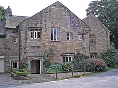
Hurstwood Hall, built in 1579
Location map United Kingdom Borough of Burnley.svg
Red pog.svg
Hurstwood
Shown within Burnley Borough
Lancashire UK location map.svg
Red pog.svg
Hurstwood
Location within Lancashire
OS grid reference SD881313
Civil parish
District
Shire county
Region
Country England
Sovereign state United Kingdom
Post town BURNLEY
Postcode district BB10
Dialling code 01282
Police Lancashire
Fire Lancashire
Ambulance North West
UK Parliament
List of places
UK
England
Lancashire
53°46′41″N2°10′55″W / 53.778°N 2.182°W / 53.778; -2.182 Coordinates: 53°46′41″N2°10′55″W / 53.778°N 2.182°W / 53.778; -2.182

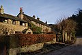
Hurstwood is a rural hamlet on the eastern outskirts of Burnley in Lancashire, England. It is in the civil parish of Worsthorne-with-Hurstwood and the borough of Burnley.

Contents

History

The Old English word hyrst is thought to mean a wooded prominence, as 'wood' (OE wudu) has been appended, it may just mean a prominence in this case. [1]

The older part of the settlement contains three buildings that are recorded in the National Heritage List for England as designated Grade II* listed buildings, being particularly important buildings of more than special interest. Hurstwood Hall, the Great Barn next to it, and Spencer House are all thought to have been constructed in late 16th century. [2] [3] [4]

It is believed that the Elizabethan poet Edmund Spenser was part of the family that built Spenser House in Hurstwood. Scenes from the 1996 BBC adaptation of The Tenant of Wildfell Hall were filmed at Spenser House and Hurstwood Hall. [5]

Geography

To the east is Hurstwood reservoir, and south-east is Cant Clough reservoir, both are passed by the Mary Towneley Loop section of the Pennine Bridleway National Trail and the Burnley Way footpath. The River Brun is usually said to begin at the confluence of Hurstwood Brook and Rock Water at the edge of the hamlet.

People

See also

Related Research Articles

Borough of Burnley Borough in England

The Borough of Burnley is a local government district of Lancashire, England, with the status of a non-metropolitan district and borough. It has an area of 42.7 square miles (110.7 km2) and a population of 88,920 (mid-2019 est.), and is named after its largest town, Burnley. The borough is bounded by Hyndburn, Ribble Valley, Pendle, Rossendale – all in Lancashire – and the borough of Calderdale in West Yorkshire. It is governed by Burnley Borough Council, which is currently under no overall control following the 2019 local elections.

Gawthorpe Hall Grade I listed Elizabethan country house

Gawthorpe Hall is an Elizabethan country house on the banks of the River Calder, in the civil parish of Ightenhill in the Borough of Burnley, Lancashire, England. Its estate extends into Padiham, with the Stockbridge Drive entrance situated there. Since 1953 it has been designated a grade I listed building. The hall is financed and run by the National Trust in partnership with Lancashire County Council. In 2015 the Hall was given £500,000 funding from the council for vital restoration work needed on the south and west sides of the house.

River Brun River in eastern Lancashire, England

The River Brun is a river in eastern Lancashire. It is approximately 4.5 miles (7.2 km) long and has a catchment area of 9.32 square miles (24.134 km2).

Worsthorne Human settlement in England

Worsthorne is a rural village on the eastern outskirts of Burnley in Lancashire, England. It is in the civil parish of Worsthorne-with-Hurstwood and the borough of Burnley. At the 2011 census the village had a population of 1,028.

Burnley Way Long-distance footpath in Lancashire, England

The Burnley Way is a 40-mile (64 km) long distance footpath in Lancashire, England. As a circular walk it can be walked from any point, but it is common to start and finish at the Weavers' Triangle Visitor Centre in Burnley. It covers a range of terrain from canal towpaths to open moorland.

Briercliffe Human settlement in England

Briercliffe is a civil parish in the borough of Burnley, in Lancashire, England. It is situated 3 miles (4.8 km) north of Burnley. The parish contains suburbs of Burnley, and the rural area north east of the town. Hamlets in the parish include Cockden, Lane Bottom and in the Extwistle area, the tiny hamlet of Roggerham. According to the United Kingdom Census 2011, the parish has a population of 4,031.

Worsthorne-with-Hurstwood Human settlement in England

Worsthorne-with-Hurstwood is a civil parish in the Borough of Burnley, in Lancashire, England. Situated on the eastern outskirts of Burnley, in 2011 it had a population of 2,963.

Listed buildings in Rivington

Rivington in the Borough of Chorley, Lancashire, is situated on the edge of the West Pennine Moors, at the foot of Rivington Pike overlooking reservoirs created for Liverpool Corporation Waterworks in the 19th century. There are twenty eight listed buildings within Rivington, two are classified by English Heritage as Grade II*, the rest as Grade II; Rivington has no Grade I Listed buildings.

Weavers Triangle Historic textie-producing area with a cotton museum in Lancashire, England

The Weavers' Triangle is an area of Burnley in Lancashire, England consisting mostly of 19th-century industrial buildings at the western side of town centre clustered around the Leeds and Liverpool Canal. The area has significant historic interest as the cotton mills and associated buildings encapsulate the social and economic development of the town and its weaving industry. From the 1980s, the area has been the focus of major redevelopment efforts.

Holme Hall, Cliviger

Holme Hall is a Grade II* listed manor house in Cliviger near Burnley, in Lancashire, England. The house dates back to at least the 15th century, was rebuilt in the 17th century, and extended in 1854. Between 1985 and 2003 it was used as a retirement home. The structure was devastated by suspected arson attacks in 2003 and remained derelict for more than a decade before being redeveloped into apartments in 2016.

St John the Evangelists Church, Worsthorne Church in Lancashire, England

St John the Evangelist's Church is in Church Square in the village of Worsthorne, Lancashire, England. It is an active Anglican parish church in the deanery of Burnley, the archdeaconry of Burnley, and the diocese of Blackburn. The church is recorded in the National Heritage List for England as a designated Grade II listed building.

Briercliffe is a civil parish in the borough of Burnley, Lancashire, England. The parish contains 21 buildings that are recorded in the National Heritage List for England as designated listed buildings. Of these, one is listed at Grade I, the highest of the three grades, two at Grade II*, the middle grade, and the others are at Grade II, the lowest grade.

Cliviger is a civil parish in the borough of Burnley, Lancashire, England. The parish contains 22 listed buildings that are recorded in the National Heritage List for England. Of these, two are listed at Grade II*, the middle grade, and the others are at Grade II, the lowest grade. Apart from small settlements, the parish is rural, and most of the listed buildings are or have been farmhouses, farm buildings, and associated structures. Also in the parish are large houses, a parish church, the base of a cross, a public house, two war memorials, and two boundary stones.

Hapton is a civil parish in the borough of Burnley, Lancashire, England. The parish contains seven buildings that are recorded in the National Heritage List for England as designated listed buildings. Of these, one is listed at Grade I, the highest of the three grades, one at Grade II*, the middle grade, and the others are at Grade II, the lowest grade. Apart from the village of Hapton, and some industrial encroachment from Burnley to the northeast the parish is rural. Three of the listed buildings are or have been farmhouses. The most notable building in the parish is Shuttleworth Hall; this together with associated structures, is listed. The Leeds and Liverpool Canal passes through the parish, and two of the bridges crossing it are listed.

Ightenhill is a civil parish in the borough of Burnley, Lancashire, England. The parish contains 15 buildings that are recorded in the National Heritage List for England as designated listed buildings. Of these, two are listed at Grade I, the highest of the three grades, and the others are at Grade II, the lowest grade. The parish is partly rural, and partly residential as a district of the town of Burnley. The most notable buildings in the parish are Gawthorpe Hall and its Great Barn. These are both listed, as are structures associated with them. The other listed buildings include a farmhouse dating from the 16th century, a former schoolmaster's house, a parish church and its churchyard wall, a drinking fountain, and two boundary stones.

Worsthorne-with-Hurstwood is a civil parish in the borough of Burnley, Lancashire, England. The parish contains 22 buildings that are recorded in the National Heritage List for England as designated listed buildings. Of these, four are listed at Grade II*, the middle grade, and the others are at Grade II, the lowest grade. Apart from the village of Worsthorne and the settlement of Hurstwood, the parish is rural. Most of the listed buildings are farmhouses, or originated as farmhouses or farm buildings. Other listed buildings include large houses and associated structures, a row of former back-to-back cottages, a church, and a telephone kiosk.

Burnley is a town in Lancashire, England. Its unparished area contains 190 buildings that are recorded in the National Heritage List for England as designated listed buildings. Of these, one is listed at Grade I, the highest of the three grades, three are at Grade II*, the middle grade, and the others are at Grade II, the lowest grade.

Bretherton is a civil parish in the Borough of Chorley, Lancashire, England. The parish contains 19 buildings that are recorded in the National Heritage List for England as designated listed buildings. Of these, two are listed at Grade II*, the middle grade, and the others are at Grade II, the lowest grade. Apart from the village of Bretherton, the parish is rural. Most of the listed buildings are, or originated as, farmhouses or farm buildings. The other listed buildings include a medieval cross base, two historic houses, a cottages, a former school a converted windmill, a church, a rectory, and a war memorial

Scarisbrick is a civil parish in the West Lancashire district and borough of Lancashire, England. It contains 32 buildings and structures that are recorded in the National Heritage List for England as designated listed buildings. Of these, one is listed at Grade I, the highest of the three grades, and the others are at Grade II, the lowest grade. The most significant building in the parish is Scarisbrick Hall which is listed at Grade I, with several associated structures being listed separately. The parish is a collective of smaller hamlets and is largely rural. Many of the listed buildings are houses, farmhouses or other agricultural buildings that have since been repurposed as dwellings, while the others include a telephone kiosk and the Roman Catholic Church of St Elizabeth.

Burscough is a civil parish in the West Lancashire district of Lancashire, England. It contains 38 buildings that are recorded in the National Heritage List for England as designated listed buildings. Of these, two are at Grade II*, the middle grade, and the others are at Grade II, the lowest grade. The parish contains the large village of Burscough, the rural hamlet of Tarlscough, and the surrounding countryside. Passing through the parish is the Leeds and Liverpool Canal, and the junction between the canal and its Rufford Branch is in the parish. Also passing through the parish are the railways of the Ormskirk - Preston and the Manchester-Southport Lines, which cross in the parish. The oldest listed buildings are farmhouses and farm buildings, and houses and cottages. Associated with the canal are the structures at the junction, bridges and a lock. Associated with the railways are station buildings and a bridge. The other listed buildings include churches, a war memorial, and a former mill and its offices.

References

Citations

  1. Ekwall, Eilert (1922). The place-names of Lancashire. Manchester University Press. p.  86. OCLC   82106091.
  2. Historic England & 1205736
  3. Historic England & 1072638
  4. Historic England & 1280543
  5. "Burnley: Hamlet's echoes of the Brontes". Lancashire Telegraph . 2 March 2006. Archived from the original on 7 October 2012.
  6. Historic England & 1205773

Sources