Habergham Eaves

Last updated

Habergham Eaves
Pair of white houses - geograph.org.uk - 124139.jpg
Buildings at Higher Timber Hill Farm
Location map United Kingdom Borough of Burnley.svg
Red pog.svg
Habergham Eaves
Shown within Burnley Borough
Lancashire UK location map.svg
Red pog.svg
Habergham Eaves
Location within Lancashire
Area2.87 sq mi (7.4 km2)  [1]
Population1,466 (2011) [1]
  Density 511/sq mi (197/km2)
OS grid reference SD8319229904
Civil parish
  • Habergham Eaves
District
Shire county
Region
Country England
Sovereign state United Kingdom
Post town BURNLEY
Postcode district BB11
Dialling code 01282
Police Lancashire
Fire Lancashire
Ambulance North West
UK Parliament
List of places
UK
England
Lancashire
53°45′54″N2°15′18″W / 53.765°N 2.255°W / 53.765; -2.255

Habergham Eaves is a civil parish in the borough of Burnley, in Lancashire, England. The parish consists of a rural area south of Burnley, and suburban areas on the outskirts of the town, including a large industrial estate in the north-west corner of the parish. Habergham is also the name of an area west of Burnley, although it is no longer within the parish. [2] According to the United Kingdom Census 2011, the parish has a population of 1,466. [1]

Contents

The A646 Padiham to Todmorden road runs approximately along the northern boundary of the parish. Surrounding areas include the unparished areas of Burnley and Rossendale, and the parishes of Hapton, Dunnockshaw and Cliviger.

History

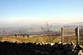
Early forms of the name include "Habringham", with the third and second elements probably from the Old English words hām, meaning home and ing in this sense meaning "of the". Its first is less certain, possibly hēah with beorg meaning high hill or mountain—perhaps the origin of Horelaw, the name of the hill on which the parish is situated—or alternatively a personal name. The addition Eaves OE efes could mean "edge of a hill". There is also part of the parish called Oaken Eaves. [3]

Habergham Eaves township historically extended further to the north from Gawthorpe Hall in the west to Towneley Hall in the east, the River Calder generally separating it from the neighbouring townships. [4]

Now located in an isolated position in Cross Field near the former Bull and Butcher Inn is the base of a cross, thought to be a butter cross possibly of late medieval origin. [5] [4]

Considered part of the Burnley Coalfield, coal may have been mined here from the mid 15th century, but certainly by early 1500s. After Richard Towneley obtained a lease from the Crown to mine at Broadhead, he launched a legal action in the Duchy Court, complaining that on 7 May 1526 a group of about eighty of the king's tenants had entered the "coal beds" here to obtain coal for themselves. This group included Hugh Habergham and another Richard Towneley from the branch of the family at Royle Hall. The tenants claimed the right to "sufficient coal for their fuel, for their necessary occupation and burning within their houses". One witness said that around 1450 two men who had a smithy in Bentley Wood searched for iron at Broadhead and found coal and began mining it. With the son of one of them later setting-up a windlass. [4] [6]

The Towneleys where involved in another legal battle over land rights here in 1568. Local farmers alleged that half a century before Sir John Towneley had used forged documentation to create an enclosed area that had become known as Horelaw Pasture. A Duchy Special Commission subsequently found this to have been an encroachment and confiscated the approximately 400-acre (160 ha) area, situated directly south of another enclosure called Hollin Hey. However shortly after James I came to the English throne, the land was granted to the 1st Earl of Devonshire, and before 1612 another Richard Towneley, the great-grandson of Sir John, was able to reacquire it. This made Sir John so unpopular with the local people a tradition arose that his ghost wanders the hills calling "Be warned! Lay out! Be warned! Lay out! Around Horelaw and Hollin Hey Clough". [7] [4]

Crown Point Road was built as part of the first attempt by a Turnpike Trust to improve the journey between Burnley and Rochdale following an Act in 1754-55. From Bacup it connected to the existing roads at the junction of Cog Lane and what is now Rossendale Road. The Burnley and Edenfield Trust built the A682—formerly the A56—Manchester Road soon after 1795, crossing the other at the former Bull and Butcher Inn where a toll bar was situated. In 1817 the Rochdale and Burnley Trust commenced work on what is now the A671 Bacup/Todmorden Road, which forms part of the modern parish boundary (along with a branch through Cliviger to Todmorden). This was connected to Crown Point Road at Windy Bank in Cliviger, before continuing to Burnley at Turf Moor, greatly reducing the older road's importance. [8]

In 1861 the Borough of Burnley was formed, and in 1894 a large part of the township, with a population of over 40,000 and including Rose Grove, Burnley Wood, Gannow and Habergham, was transferred to the County Borough of Burnley, and taken out of the control of the newly established Lancashire County Council. The remainder, with the exception of a small area transferred to Ightenhill, became the civil parish of Habergham Eaves. [9] [4]

In April 1941, during World War II a Starfish site bombing decoy was constructed off Crown Point Road, part of a network designed to protect Accrington. [10] On 6 May 1941, a string of eight bombs straddled houses around Rossendale Avenue on the southern edge of Burnley, causing only minor damage. On the night of 12 October the Starfish site was targeted by the Luftwaffe and the control shelter suffered a direct hit. Aircraftsman L R Harwood was killed whilst Sergeant D A Murphy, Aircraftsman D R Fryatt, Aircraftsman J Owen, and Aircraftsman E A Jones were all injured as a result of enemy action. [11] [12] By the end of the year the sites were upgraded to incorporate Quick Light (QL) decoys, and they continued to operate until spring 1943, and the site was subsequently cleared. [10]

Habergham Hall

Although most of the land in the township was held by copyhold of the manor of Ightenhill, a freehold estate, sometimes described as a manor, called Habergham existed here. The ancient Habergham Hall, of which there are now no remains, stood near the western side of the township, overlooking Habergham Clough, the boundary with Hapton. A family was already using the surname when the lord of Clitheroe, Roger de Lacy, who died in 1211, gave an oxgang of land here to Matthew de Habergham and his heirs. The estate descended in 1615 to John Habergham, then aged sixteen. After the English Civil War his descendants sold the estate in parts, George Halsted becoming the owner of the hall in 1689 as the result of the foreclosure of a mortgage. The present Habergham Hall farmhouse was built on the site in 1754, and later came into the possession of the branch of the Halstead family at Rowley Hall in Worsthorne-with-Hurstwood, who sold it in the mid 1800s. [4]

Governance

Habergham Eaves was once a township in the ancient parish of Whalley. This became a civil parish in 1866, forming part of the Burnley Rural District from 1894. [9] Since 1974 Habergham Eaves has formed part of the Borough of Burnley. A boundary change which took effect at the start of 1983, transferred a small part of parish lying west of Limey Lane into Dunnockshaw. [13]

Along with Dunnockshaw and a small part of Burnley, the parish forms the Coalclough with Deerplay ward of the borough council. [14] The ward elects three councillors, currently Gordon Birtwistle, Howard Baker, and Jacqueline Inckle of the Liberal Democrats. [15] The parish is represented on Lancashire County Council as part of the Padiham & Burnley West division, represented since 2017 by Alan Hosker (Conservative). [16]

The Member of Parliament for Burnley, the constituency into which the parish falls, is Antony Higginbotham (Conservative), who was first elected in 2019.

Demography

According to the United Kingdom Census 2011, the parish has a population of 1,466, a decrease from 1,581 in the 2001 census. This represents a decline of

In 2011 the average (mean) age of residents was 43.4 years, with a roughly even distribution between males and females. The racial composition was 98.4% White (96.6% White British), 1.2% Asian, 0.1% Black and 0.3% Mixed. The largest religious groups were Christian (79.1%), Hindu (0.5%) and Muslim (0.3%). 69.4% of adults between the ages of 16 and 74 were classed as economically active and in work. [1]

Year189119011911192119311951196120012011
Population46,9303964593224247567261,5811,466
[9] [17] [1]

See also

Related Research Articles

<span class="mw-page-title-main">Burnley</span> Town in England

Burnley is a town and the administrative centre of the wider Borough of Burnley in Lancashire, England, with a 2001 population of 73,021. It is 21 miles (34 km) north of Manchester and 20 miles (32 km) east of Preston, at the confluence of the River Calder and River Brun.

Burnley Wood is a district and former electoral ward of Burnley, Lancashire. In broad terms the area lies between Parliament Street in the north and Hufling Lane in the south, and from the railway in the west to Todmorden Road in the east. Based on historic definitions of the ward boundary, Burnley Wood could also be defined as including the more affluent areas around the Woodgrove Road area to the east of Todmorden Road, Brooklands Road to the south and the area north of Parliament Street as far as the River Calder. Historically the district was located in the parish and township of Habergham Eaves, separated from the adjacent Burnley township, later Borough by the Calder before being incorporated into the County Borough of Burnley in 1894.

<span class="mw-page-title-main">Padiham</span> Town in Lancashire, England

Padiham is a market town and civil parish on the River Calder, in the Borough of Burnley in Lancashire, England. It is located north west of Burnley, and north east of the towns of Clayton le Moors and Great Harwood. It is edged by the foothills of Pendle Hill to the north-west and north-east. The United Kingdom Census 2011 gave a parish population of 10,098, estimated in 2019 at 10,138.

<span class="mw-page-title-main">Borough of Burnley</span> Borough in Lancashire, England

The Borough of Burnley is a local government district with the borough status in Lancashire, England. It has an area of 42.7 square miles (110.7 km2) and a population of 94,721 (2021), and is named after its largest town, Burnley. The borough also contains the town of Padiham along with several villages and surrounding rural areas.

<span class="mw-page-title-main">Blackburn Hundred</span> Former sub-division of Lancashire, UK

Blackburn Hundred is a historic sub-division of the county of Lancashire, in northern England. Its chief town was Blackburn, in the southwest of the hundred. It covered an area similar to modern East Lancashire, including the current districts of Ribble Valley, Pendle, Burnley, Rossendale, Hyndburn, Blackburn with Darwen, and South Ribble.

<span class="mw-page-title-main">Dunnockshaw</span> Human settlement in England

Dunnockshaw or Dunnockshaw and Clowbridge is a civil parish in the borough of Burnley, in Lancashire, England. The parish is situated between Burnley and Rawtenstall. According to the United Kingdom Census 2011, the parish has a population of 185.

<span class="mw-page-title-main">Bowland Forest Low</span> Human settlement in England

Bowland Forest Low is a civil parish in the Ribble Valley district of Lancashire, England, covering some 5,500 acres (22 km2) of the Forest of Bowland. According to the 2001 census, the parish had a population of 168, falling to 160 at the 2011 Census. The parish includes the hamlets of Whitewell and Cow Ark. From northwards clockwise, it borders the civil parishes of Newton, Bashall Eaves, Aighton, Bailey and Chaigley, Bowland-with-Leagram and Bowland Forest High. Before 1974, it formed part of Bowland Rural District in the West Riding of Yorkshire.

Burnley was a Rural district of Lancashire, England from 1894 to 1974. It was named after but did not include the large town of Burnley, which was a county borough.

<span class="mw-page-title-main">River Calder, Lancashire</span> Tributary of the River Ribble in England

The River Calder is a major tributary of the River Ribble in Lancashire, England, and is around 20 miles (32 km) in length.

<span class="mw-page-title-main">Cliviger</span> Human settlement in England

Cliviger is a civil parish in the Borough of Burnley, in Lancashire, England. It is situated to the southeast of Burnley, and northwest of Todmorden. According to the 2011 census, the parish has a population of 2,238.

<span class="mw-page-title-main">Weir, Lancashire</span> Human settlement in England

Weir is a village to the north of Bacup in the Rossendale borough of Lancashire, England, and immediately south of the boundary with the Borough of Burnley. The village had a population of 1,251 at the 2011 Census. Anciently, Weir constituted a hamlet, but later emerged as an outlying suburb of Bacup town after the Burnley Road turnpike was built through the settlement at the end of the 18th Century.

<span class="mw-page-title-main">Ightenhill</span> Parish in Burnley, England

Ightenhill is a civil parish in the Borough of Burnley in Lancashire, England, with a population of 1,975.

<span class="mw-page-title-main">Hapton, Lancashire</span> Human settlement in England

Hapton is a village and civil parish in the Borough of Burnley in Lancashire, England, 3 miles (4.8 km) west of Burnley, with a railway station on the East Lancashire Line. At the United Kingdom Census 2011, it had a population of 1,979.

<span class="mw-page-title-main">Burnley Way</span> Long-distance footpath in Lancashire, England

The Burnley Way is a 40-mile (64 km) long distance footpath in Lancashire, England. As a circular walk it can be walked from any point, but it is common to start and finish at the Weavers' Triangle Visitor Centre in Burnley. It covers a range of terrain from canal towpaths to open moorland.

<span class="mw-page-title-main">Worsthorne-with-Hurstwood</span> Human settlement in England

Worsthorne-with-Hurstwood is a civil parish in the Borough of Burnley, in Lancashire, England. Situated on the eastern outskirts of Burnley, in 2011 it had a population of 2,963.

<span class="mw-page-title-main">Honour of Clitheroe</span>

The Honour of Clitheroe is an ancient grouping of manors and royal forests centred on Clitheroe Castle in Lancashire, England; an honour traditionally being the grant of a large landholding complex, not all of whose parts are contiguous. In the case of Clitheroe, this complex was loosely clustered around the ancient wapentake of Blackburnshire.

<span class="mw-page-title-main">Hameldon Hill</span>

Hameldon Hill is a Carboniferous sandstone hill with a summit elevation of 409 metres (1,342 ft), situated between the towns of Burnley and Accrington in Lancashire, England. It is listed as a "HuMP" or "Hundred Metre Prominence", its parent being Freeholds Top, a Marilyn near Bacup.

Ightenhill is a civil parish in the borough of Burnley, Lancashire, England. The parish contains 15 buildings that are recorded in the National Heritage List for England as designated listed buildings. Of these, two are listed at Grade I, the highest of the three grades, and the others are at Grade II, the lowest grade. The parish is partly rural, and partly residential as a district of the town of Burnley. The most notable buildings in the parish are Gawthorpe Hall and its Great Barn. These are both listed, as are structures associated with them. The other listed buildings include a farmhouse dating from the 16th century, a former schoolmaster's house, a parish church and its churchyard wall, a drinking fountain, and two boundary stones.

<span class="mw-page-title-main">Burnley Coalfield</span> Coal mining region in England

The Burnley Coalfield is the most northerly portion of the Lancashire Coalfield. Surrounding Burnley, Nelson, Blackburn and Accrington, it is separated from the larger southern part by an area of Millstone Grit that forms the Rossendale anticline. Occupying a syncline, it stretches from Blackburn past Colne to the Yorkshire border where its eastern flank is the Pennine anticline.

References

  1. 1 2 3 4 5 6 UK Census (2011). "Local Area Report – Habergham Eaves Parish (E04005134)". Nomis. Office for National Statistics . Retrieved 28 March 2021.
  2. "Map of Habergham Eaves parish". MARIO. Lancashire County Council . Retrieved 3 November 2008.
  3. Ekwall, Eilert (1922). The place-names of Lancashire. Manchester University Press. pp. 82–83. Retrieved 24 July 2021.
  4. 1 2 3 4 5 6 William Farrer; J. Brownbill, eds. (1911). Townships: Habergham Eaves. A History of the County of Lancaster. Vol. 6. University of London & History of Parliament Trust. pp. 454–468. Retrieved 24 July 2021.
  5. Historic England, "Base of former Butter Cross, Habergham Eaves (1274582)", National Heritage List for England , retrieved 24 July 2021
  6. Henry Fishwick, ed. (1896). Pleadings and Depositions in the Duchy Court of Lancaster. Time of Henry VII. and Henry VIII. Vol. 32. Record Society for the Publication of Original Documents relating to Lancashire and Cheshire. pp. 138–145. Retrieved 24 July 2021.
  7. Whitaker, Thomas Dunham (1876). An history of the original Parish of Whalley, and honor of Clitheroe... Vol. 2 (4th ed.). George Routledge. p. 188. OCLC   697798990 . Retrieved 28 May 2021.
  8. Bennett, Walter (1948). The History of Burnley 1650–1850. Burnley Corporation. pp. 148, 150–151. ASIN   B0032OO3MM.
  9. 1 2 3 "Habergham Eaves Tn/CP Lancashire through time: Administrative History of Parish-level unit: hierarchies, boundaries". A Vision of Britain through Time . University of Portsmouth & others. Retrieved 28 March 2021.
  10. 1 2 Historic England. "STARFISH BOMBING DECOY SF35C (1469064)". Research records (formerly PastScape). Retrieved 1 August 2015.
  11. "Blitzed! When Hitler's bombs brought death and terror". Lancashire Telegraph. 18 August 1997. Retrieved 20 July 2021.
  12. "RAF and Commonwealth Air Forces AIR81". RAFCommands. Retrieved 19 July 2021.
  13. "The Burnley (Parishes) Order 1982" (PDF). LGBCE. 29 September 1982. Retrieved 11 April 2021.
  14. "Wards and parishes map". MARIO. Lancashire County Council. Retrieved 28 March 2021.
  15. "Your Councillors". burnley.moderngov.co.uk. Burnley Borough Council. Retrieved 5 August 2023.
  16. "County Councillors by Local Community". Lancashire County Council. Retrieved 5 August 2023.
  17. 1 2 UK Census (2001). "Local Area Report – Habergham Eaves Parish (30UD004)". Nomis. Office for National Statistics . Retrieved 28 March 2021.
  18. UK Census (2011). "Local Area Report – Burnley Built-up area (E34004743)". Nomis. Office for National Statistics. Retrieved 6 March 2021.

Commons-logo.svg Media related to Habergham Eaves at Wikimedia Commons