
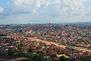
Ibadan is the capital and most populous city of Oyo State, in Nigeria. It is the third-largest city by population in Nigeria after Lagos and Kano, with a total population of 2,649,000 as of 2021, and over 3 million people within its metropolitan area. It is one of the country's largest cities by geographical area. At the time of Nigeria's independence in 1960, Ibadan was the largest and most populous city in the country, and the second-most populous in Africa behind Cairo. Ibadan is ranked one of the fastest-growing cities in sub-Saharan Africa, according to the UN Human Settlements Program (2022). It is also ranked third in West Africa in the tech startups index. Ibadan joined the UNESCO Global Network of Learning Cities in 2016.
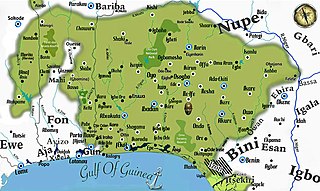
Yorubaland is the homeland and cultural region of the Yoruba people in West Africa. It spans the modern-day countries of Nigeria, Togo and Benin, and covers a total land area of 142,114 km2 (54,871 sq mi). Of this land area, 106,016 km2 (74.6%) lies within Nigeria, 18.9% in Benin, and the remaining 6.5% is in Togo. Prior to European colonization, a portion of this area was known as Yoruba country. The geo-cultural space contains an estimated 55 million people, the majority of this population being ethnic Yoruba.
Ogun State is a state in southwestern Nigeria. As a Nigerian state, Ogun is the second most industrialised state after Lagos, with a focus on metal processing. It has good road and rail connections to the harbours in Lagos and Lekki. Wole Soyinka, winner of the Nobel Prize for Literature 1986, lives in Ogun.
Ketu is the name of a Yoruba subgroup, historical kingdom and region straddling parts of what is now southeastern Republic of Benin and parts of southwest Nigeria. The chief town and traditional capital of the area was the town of Kétou (Kétu), which is considered to be one of the oldest capitals of the Yoruba-speaking people, tracing its establishment to a settlement founded by a descendant of Oduduwa called Sopasan or Soipasan. The Oba of the town were traditionally styled "Alákétu", and are related directly to Ile-Ife in present-day Nigeria. Other towns that were historically part of the Kétu Kingdom are;

Oyo State is an inland state in southwestern Nigeria. Its capital is Ibadan, the third most populous city in the country and formerly the second most populous city in Africa. Oyo State is bordered to the north by Kwara State for 337 km, to the east by Osun State for 187 km, partly across the River Osun, and to the south by Ogun State, and to the west by the Republic of Benin for 98 km. With a projected population of 7,976,100 in 2022, Oyo State is the sixth most populous in the Nigeria.
The Ẹgbado, now Yewa, are a subgroup of the Yoruba people and inhabit the eastern area of Ogun West Senatorial District, Ogun State, in south-west Nigeria, Africa. In 1995 they changed their name to the Yewa which comes from the Yewa River which in turn comes from the Yoruba goddess Yewa. Yewa occupy four Local Government Areas, Yewa South, Yewa North, Imeko-Afon, and Ipokia, while the Ado-Odo/Ota LGA forms the fifth Awori part of the senatorial district.
Abeokuta is the capital city of Ogun State in southwest Nigeria. It is situated on the east bank of the Ogun River, near a group of rocky outcrops in a wooded savanna; 77 kilometres (48 mi) north of Lagos by railway, or 130 kilometres (81 mi) by water. As of 2006, Abeokuta and the surrounding area had a population of 449,088.
Igbo-Ora is a city and the headquarters of Ibarapa Central, Oyo State, south-western Nigeria, situated 80 kilometres (50 mi) north of Lagos. In 2006 the population of the town was approximately 72,207 people. In 2017 the population is estimated to be around 278,514 people.
Sepeteri is the biggest town in the Saki East Local Government Area of Oke-Ogun Oyo State, Nigeria. The Yoruba people of Sepeteri are related with fon (ruler) of Dahomey and Ifon in Osun State their crownship is Obatala, Obalufon lineage under Oyo Empire. Sepeteri is located between Igboho, Ago-amodu and Oje Owode to Shaki, Ago-Are and Iseyin.
Ido is a Local Government Area in Oyo State, Nigeria. Its headquarters are in the town of Ido.

Ibarapa Central is a Local Government Area in Oyo State, Nigeria. The Ibarapa central consist of Igbo-Ora and Idere town. Its headquarter is in the town of Igbo-Ora.
Ibarapa East is a Local Government Area in Oyo State, Nigeria, made up of the Ibarapa people. Its headquarters are in the town of Eruwa.
Ibarapa North is a Local Government Area in Oyo State, Nigeria. It was created in 1996 from old Ifeloju L.G. Its headquarters are in the town of Ayete. Other notable towns in the LG are Tapa and Igangan. Each of the towns has quite a number of villages. The current chairman is Lateef Adebayo Lawal (PDP).
Ado-Odo is the metropolitan headquarters of the ancient kingdom of Ado, renowned for its Oduduwa/Obatala temple, the ancient fortress of the traditional practice of Ifá. Oodu'a is also regarded by traditionalists as the mother of all deities, world over. All of these made Ado an inviolate territory in western Yorubaland—the same "father-figure" status accorded to Ile-Ife. Unlike the other kingdoms, which had at one time or the other engaged in the internecine wars that ravaged Yorubaland in the nineteenth century, Ado stood out as an unconquered sanctuary city-state throughout the period.
Egba Ake, otherwise known as Egba Alake, is one of the four sections of Egbaland, the others being Oke-Ona, Gbagura, and the Owu.
Joseph Adebowale Atanda was a Nigerian native of Eruwa, in Oyo State, Nigeria. He obtained his B.A. (Hons) in History in 1964 from the University of London and a PhD. in history in 1967 from the University of Ibadan.
Eruwa (Yoruba: Èrúwà or fully meaning 'pieces of yam are available here' is a town and the headquarters of Ibarapa East Local Government Area in south-western Nigeria located in Oyo state. Eruwa is 72 km south west of Ibadan and 60 km north east of Abeokuta.
Wasinmi or Wasimi is an Egba town located on the Lagos-Abeokuta Expressway in Ewekoro local government of Ogun State. It is a few miles from Abeokuta. It is home to one of the oldest churches in the area, St. Michael's Anglican Church, and home to Odegbami International College and Sports Academy.
Igangan is a town in Ibarapa North Local Government Area of Oyo State, Nigeria. Its neighbouring towns are Ayete and Tapa.
The 2023 Nigerian presidential election in Oyo State will be held on 25 February 2023 as part of the nationwide 2023 Nigerian presidential election to elect the president and vice president of Nigeria. Other federal elections, including elections to the House of Representatives and the Senate, will also be held on the same date while state elections will be held two weeks afterward on 11 March.
