Iconium, Missouri | |
|---|---|
 | |
| Coordinates: 38°06′21″N93°32′41″W / 38.10583°N 93.54472°W | |
| Country | United States |
| State | Missouri |
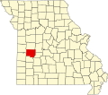
| County | St. Clair |
| Elevation | 932 ft (284 m) |
| Time zone | Central (CST) |
| GNIS feature ID | 756204 [1] |
Iconium is an unincorporated community in St. Clair County, Missouri, United States. [1] The town is perhaps best known for "Scott's Iconium Store," a local institution that is a frequent pilgrimage destination for Boy Scouts, due to the community's proximity to the H. Roe Bartle Scout Reservation. [2]
Iconium was founded in 1879, and named after the ancient city of Iconium, which today is known as Konya, in central Turkey. [3] A post office called Iconium was established in 1871, and remained in operation until 1959. [4]