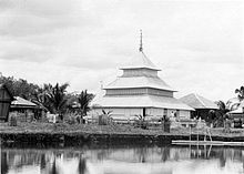
Riau is a province of Indonesia. It is located on the central eastern coast of the island of Sumatra, and extends from the eastern slopes of the Barisan Mountains to the Malacca Strait, including several large islands situated within the Strait. The province shares land borders with North Sumatra to the northwest, West Sumatra to the west, and Jambi to the south, and a maritime border with the Riau Islands and the country of Malaysia to the east. It is the second-largest province in the island of Sumatra after South Sumatra, and is slightly larger than the nation of Jordan. According to the 2020 census, Riau had a population of 6,394,087 across a land area of 89,935.90 km²; the official estimate of population as of mid-2023 was 6,642,874. The province comprises ten regencies and two cities, with Pekanbaru serving as the capital and largest city.

West Sumatra is a province of Indonesia. It is on the west coast of the island of Sumatra and includes the Mentawai Islands off that coast. West Sumatra borders the Indian Ocean to the west, as well as the provinces of North Sumatra to the north, Riau to the northeast, Jambi to the southeast, and Bengkulu to the south. The province has an area of 42,119.54 km2 (16,262.45 sq mi), or about the same size as Switzerland, with a population of 5,534,472 at the 2020 census. The official estimate at mid 2023 was 5,757,210. The province is subdivided into twelve regencies and seven cities. It has relatively more cities than other provinces outside Java, although several of them are relatively low in population compared with cities elsewhere in Indonesia. Padang is the province's capital and largest city.
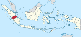
Jambi is a province of Indonesia. It is located on the east coast of central Sumatra and stretches to the Barisan Mountains in the west. Its capital and largest city is also called Jambi. It is bordered by the provinces of Riau to the north, West Sumatra to the west, Bengkulu to the southwest, South Sumatra to the south, and shares a maritime border with the Riau Islands to the east and the Pacific Ocean to the east. The province has a land area of 49,026.58 km2, and a sea area of 3,274.95 km2. Its area is comparable to the European country of Slovakia. It had a population of 3,092,265 according to the 2010 census and 3,548,228 according to the 2020 census; the official estimate of population as of mid-2023 was 3,679,169.
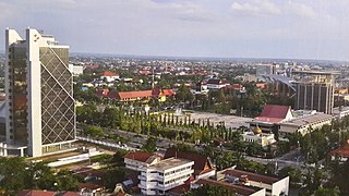
Pekanbaru is the capital city of the Indonesian province of Riau, and a major economic center on the eastern side of Sumatra Island with its name derived from the Malay (Indonesian) word for 'new market' . It has an area of 632.26 km2 (244.12 sq mi), with a population of 897,767 at the 2010 Census, and 983,356 at the 2020 Census; the official estimate as at mid 2023 was 1,123,348. It is located on the banks of the Siak River, which flows into the Strait of Malacca, Pekanbaru has direct access to the busy strait and has long been known as a trading port.

The Johor Sultanate was founded by Sultan of Malacca Mahmud Shah's son, Alauddin Riayat Shah II in 1528.
Teluk Intan is a town in Hilir Perak District, Perak, Malaysia. It is the district capital, the largest town in the district and fourth largest town in the state of Perak with an estimated population of around 172,505, more than half of Hilir Perak district's total population (232,900).

The architecture of Indonesia reflects the diversity of cultural, historical, and geographic influences that have shaped Indonesia as a whole. Invaders, colonizers, missionaries, merchants, and traders brought cultural changes that had a profound effect on building styles and techniques.

Sultan Thaha Syaifuddin Airport, formerly known as Palmerah Airport, is in Jambi City in the Jambi province of Indonesia. It is located in the Paalmerah suburb of Jambi. The airport is named after Thaha Syaifuddin, the last Sultan of Jambi (1816–1904).

The Pontianak Kadriyah Sultanate was a Malay state that existed on the western coast of the island of Borneo from the late 18th century until its disestablishment in 1950. It was founded in 1771 by Sultan Syarif Abdurrahman Ibni Alhabib Husein bin Ahmad Alkadrie, allegedly a descendant of Husayn ibn Ali, in the area of the mouth of the triple junction of the small Kapuas River and the porcupine river which included a small area area ceded by the Sultan of Banten to the Dutch VOC. He had two political marriages in Kalimantan, the first to the princess of the Mempawah Kingdom, Utin Chandramidi, and the second in 1768 to Ratu Syahranum of the Banjar Sultanate, earning him the title Pangeran Nur Alam.

The Sultanate of Siak Sri Indrapura, often called Sultanate of Siak, was a kingdom that was located in present-day Siak Regency, and nearby other regions from 1722 to 1949. It was founded by Raja Kecil, who had close relations with the Johor Sultanate, after he failed to seize the Johor throne. The polity expanded in the 18th century to encompass much of eastern Sumatra as it brought various communities under its control through warfare and control of trade between the interior of Sumatra and the Malacca Strait. The Dutch colonial state signed a series of treaties with the Siak rulers in the 19th century, which reduced the area of state influence to the Siak River. For the remainder of the Dutch colonial era, it operated as an independent state with Dutch advisors. After Indonesia's Independence was proclaimed on 17 August 1945, the last sultan of Siak, Sultan Syarif Kasim II, declared his kingdom to join the Republic of Indonesia.
Raja Haji Fisabilillah was a Bugis-Malay warrior, and also the 4th Yang Dipertuan Muda of the Johor Sultanate from 1777 to 1784.

The Ganting Grand Mosque is a Sunni mosque located in Ganting, Padang, West Sumatra, Indonesia. Construction began in 1805, making it the oldest in Padang and one of the oldest in Indonesia. It is a Cultural Property of Indonesia.

The Jambi Sultanate, alternatively known as Djambi, was a sultanate that was centered in the modern-day province of Jambi in Indonesia.

Raha is the main town and port on Muna Island, Southeast Sulawesi, Indonesia. Raha is the capital of Muna Regency.
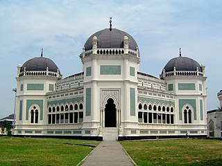
Grand Mosque of Medan or Masjid Raya Al-Mashun is a mosque located in Medan, Indonesia. The mosque was built in the year 1906 and completed in 1909. In beginning of its establishment, the mosque was a part of the Maimun palace complex. Its architectural style combines Middle Eastern, Indian, and Spanish elements. The mosque has an octagonal shape and has wings to the south, east, north, and west.
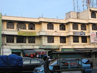
Jamiat Kheir is one of a few early private institutions in Indonesia that is engaged in education, and is instrumental in the history of Indonesian struggle against Dutch colonialism, preceding Sarekat Islam and Budi Utomo. It is headquartered in Tanah Abang, Central Jakarta.

Kasunyatan Mosque is a small mosque in the village of Kasunyatan, Banten, Indonesia. Established between 1570 and 1596, it is one of the oldest mosques in Indonesia. The mosque is located in close proximity to the ruins of Old Banten, and functioned as a 16th-century centre of Islamic study. The mosque received a heritage status during the Dutch colonial period in 1932.

The Teluk Bayur Grand Mosque, also known as Surau Ateh, is an old mosque in Indonesia which is located near the Port of Teluk Bayur, South Padang district, Padang, West Sumatra. Although the mosque was previously a surau which was recorded to have stood since the 17th century, the building that stands at its current location was built during the Dutch colonization around the 19th century.

Mosque architecture in Indonesia refers to the architectural traditions of mosques built in the archipelago of Indonesia. Initial forms of the mosque, for example, were predominantly built in the vernacular Indonesian architectural style mixed with Hindu, Buddhist or Chinese architectural elements, and notably didn't equip orthodox form of Islamic architectural elements such as dome and minaret. Vernacular architectural style varies depending on the island and region.

The Khanqah of Faraj ibn Barquq is a religious Islamic funerary complex built by the Mamluk Sultan Faraj ibn Barquq from 1400 to 1411 CE. It is located in Cairo, Egypt, in the Northern Cemetery which is a part of Cairo's historic necropolis districts. It is considered one of the most accomplished works of Mamluk architecture and one of the major monuments of Cairo's Northern Cemetery district.
