Saka Tunggal Mosque

Last updated
Saka Tunggal Mosque
Saka Tunggal Mosque (exterior, HDR), Banyumas Regency, 2015-03-22.jpg
Religion
Affiliation Islam
Branch/tradition Aboge Islam
Location
LocationCikakak, Banyumas, Central Java
Architecture
TypeMosque
Date established1871 [1]

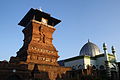
Saka Tunggal Mosque (formally Saka Tunggal Baitussalam Mosque [2] ) is a mosque located in Cikakak, Banyumas, Central Java. Established in 1871, [1] it is considered a Cultural Property of Indonesia. The complex is home to thousands of monkeys.

Contents

History

Saka Tunggal Mosque was established in 1871 CE, or 1288 hijri; [1] the latter year is inscribed on the lone pillar in the mosque. The name of the mosque is derived from this column: saka tunggal translates as "lone pillar". The roof of the central room is made of palm tree fibers. [3]

The mosque is held to have been established by Kyai Tulih (also spelled Ki Ageng Tolih), a pioneer of the Aboge school of Islam which combined the Islamic and Javanese calendars. [4] [3] The site remains sacred to followers of Aboge Islam,[ citation needed ] Saka Tunggal Mosque is often used for Eid prayers by the Aboge in Banyumas. [5]

In 2004 the mosque was designated a Cultural Property of Indonesia. [2] It is open to tourists, but under-utilized and poorly managed. Little infrastructure has been developed to support the development of the mosque and its surrounding area as a tourist object. As such, in 2014 only 2,000 visitors were recorded. [6]

Description

Interior of the mosque, showing the lone column for which it is named. Interior of Saka Tunggal Mosque, Banyumas, 2015-03-22.jpg
Interior of the mosque, showing the lone column for which it is named.
One of the monkeys on the mosque grounds Unidentified macaque, Saka Tunggal Mosque, Purwokerto 2015-03-22 03.jpg
One of the monkeys on the mosque grounds

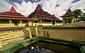
Saka Tunggal mosque is located in Cikakak, Wangon, Banyumas, Central Java, approximately 30 kilometres (19 mi) southwest of the regency's capital Purwokerto. [7] It is about 2 kilometres (1.2 mi) from the main road, over a paved road which, as of November 2014, is badly damaged. The site lacks public toilets or other facilities for tourists. [6]

Near the mosque is a graveyard where Kyai Tulih is buried. This graveyard is surrounded by a 300-metre (980 ft) bamboo fence and divided into three parts: the upper, middle, and lower cemetery. Each part of the cemetery has its juru kunci (caretaker). [3]

Every year on the 26th day of Rajab, the bamboo fence (jaro in Javanese) surrounding the cemetery is replaced in a ceremony known as Jaro Rohab. Men replace the fence, beginning near the grave of Kyai Tulih and then continuing in the direction of the mosque. Meanwhile, women prepare food for a ritual known as slametan ; the ceremony is done by the cemetery's three juru kunci. The Jaro Rojab ritual is intended to commemorate the Night Journey of Muhammad and to spiritually cleanse the participants. It attracts Muslims from much of Central and West Java, including representatives of the Surakarta Sunanate in Surakarta. [7] [4]

The area around the mosque is home to thousands of monkeys. [7] These monkeys often come to the mosque area, though they are not supposed to be fed by tourists. The monkeys are considered sacred by the local residents, and thus may not be killed or injured. During the dry season, they may attack residents' homes, stealing food or other objects. [3]

See also

Related Research Articles

<span class="mw-page-title-main">Java</span> Island in Indonesia

Java is one of the Greater Sunda Islands in Indonesia. It is bordered by the Indian Ocean to the south and the Java Sea to the north. With a population of 151.6 million people, Java is the world's most populous island, home to approximately 56% of the Indonesian population. Indonesia's capital city, Jakarta, is on Java's northwestern coast.

<span class="mw-page-title-main">Central Java</span> Province of Indonesia

Central Java is a province of Indonesia, located in the middle of the island of Java. Its administrative capital is Semarang. It is bordered by West Java in the west, the Indian Ocean and the Special Region of Yogyakarta in the south, East Java in the east, and the Java Sea in the north. It has a total area of 33,750.37 km2, with a population of 36,516,035 at the 2020 Census making it the third-most populous province in both Java and Indonesia after West Java and East Java. The official population estimate in mid-2023 was 37,608,336 The province also includes a number of offshore islands, including the island of Nusakambangan in the south, and the Karimun Jawa Islands in the Java Sea.

<span class="mw-page-title-main">Surakarta</span> City in Central Java, Indonesia

Surakarta, known colloquially as Solo, is a major city in Central Java, Indonesia. The 46.72 km2 city adjoins Karanganyar Regency and Boyolali Regency to the north, Karanganyar Regency and Sukoharjo Regency to the east and west, and Sukoharjo Regency to the south. On the eastern side of Solo lies Solo River. Its metropolitan area, consisting of Surakarta City and the surrounding six regencies, was home to 6,837,753 inhabitants according to the official estimates for mid 2023, 526,870 of whom reside in the city proper.

<span class="mw-page-title-main">Imogiri</span> Royal graveyard in Yogyakarta, Indonesia

Imogiri is a royal graveyard complex in the Special Region of Yogyakarta, in south-central Java, Indonesia, as well as a subdistrict under the administration of Bantul Regency. Imogiri is a traditional resting place for the royalty of central Java, including many rulers of the Sultanate of Mataram and the current houses of Surakarta and Yogyakarta Sultanate. The name is Imagiri is derived from the Sanskrit Himagiri, which means 'mountain of snow'. The latter is another name for Himalaya.

<span class="mw-page-title-main">Banyumas Regency</span> Regency of Indonesia

Banyumas Regency is an inland regency in the southwestern part of Central Java province in Indonesia. Its capital is the town of Purwokerto, but that town no longer has a central administration and is split over four of the districts within the Regency, with a combined population of 233,865 as of mid-2023. The Regency covers an area of 1,391.15 km2, and had a population of 1,554,527 at the 2010 Census and 1,776,918 at the 2020 Census; the official estimate of the population as of mid-2023 was 1,828,573.

<span class="mw-page-title-main">Kotagede</span> Kemantren in Java, Indonesia

Kotagede is a city district (kemantren) and a historic neighborhood in Yogyakarta, Special Region of Yogyakarta, Indonesia. Kotagede contains the remains of the first capital of Mataram Sultanate, established in the 16th century. Some of the remains of the old Kotagede are remains of the palace, the royal cemetery, the royal mosque, and defensive walls and moats. Kotagede is well known internationally for its silver crafting.

<span class="mw-page-title-main">Giriloyo</span> Locality and graveyard in Java, Indonesia

Giriloyo is a locality and graveyard in the Wukirsari valley north east of Imogiri, in Bantul Regency, Special Region of Yogyakarta, Indonesia.

<span class="mw-page-title-main">Purwokerto</span> City and capital of Banyumas Regency, Indonesia

Purwokerto is a large but non-autonomous town on the island of Java, Indonesia. It is the coordinating centre of local government and the largest city in western Central Java. Currently, Purwokerto is the capital of Banyumas Regency, Central Java province. The population of the four districts which comprise the town at the 2010 census was 233,951 and 229,271 at the 2020 census; the official estimate as of mid-2022 was 231,765. The City is considered to be the most comfortable city in Indonesia, as it is the favourite place for pensioners to live after they have finished working.

<span class="mw-page-title-main">Ahmad Dahlan</span> Indonesian Muslim religious leader and revivalist

Kyai Haji Ahmad Dahlan, often abbreviated to K.H. Ahmad Dahlan, was an Indonesian Muslim religious leader and revivalist, who established the Muhammadiyah organization. Which would become one of the largest Muslim organizations in Indonesia, second only to the Nahdlatul Ulama. Born in Kauman, Yogyakarta, he was the son of an imam of a local mosque and traced his origins from the lineage of Muhammad. Ahmad Dahlan performed the Hajj pilgrimage when he was 15 years old, and he lived in Mecca for another five years.

<span class="mw-page-title-main">Persibas Banyumas</span> Indonesian football club

Persatuan Sepakbola Indonesia Banyumas, commonly known as Persibas Banyumas, or Persibas, is an Indonesian football team based in Banyumas Regency, Central Java. They currently play in Liga 3.

<span class="mw-page-title-main">Serayu River</span> River in Central Java, Indonesia

The Serayu River is a river in Central Java, Indonesia, about 300 km southeast of the capital Jakarta.

<span class="mw-page-title-main">Wongsonegoro</span> Indonesian politician (1895–1974)

Kanjeng Raden Mas Tumenggung Wongsonegoro, more commonly known simply as Wongsonegoro, was an Indonesian politician, who served as the Deputy Prime Minister of Indonesia, alongside Zainul Arifin under Prime Minister Ali Sastroamidjojo, and the Governor of Central Java during the Indonesian National Revolution. He also served as minister in the Indonesian government several times, including as Minister of Home Affairs, Minister of Justice, and Minister of Education.

The Forbidden Forest of The Upper Cibeet River is a sacred wooded area in an old tropical forest Dayeuhluhur, in the north Cilacap Regency of Central Java, Indonesia.

<span class="mw-page-title-main">Baturraden</span>

Baturraden is a district in the Banyumas Regency on the slope of Mount Slamet, Central Java, Indonesia. It features panoramic views, waterfalls, a mini-train, paddleboats, a water slide, and a pool. Its name is derived from a legend about star-crossed lovers, a manservant (Batur) and a noblewoman (Raden).

<span class="mw-page-title-main">Fort Willem II, Ungaran</span> Building in Ungaran, Indonesia

Fort Willem II of Ungaran is a late 18th-century fort built by the Dutch in Ungaran, Semarang Regency, Central Java, Indonesia. Its main purpose was to control an important trade route between Semarang and Yogyakarta. The fort is the place where Prince Diponegoro was imprisoned while waiting for his judgment in Batavia and further exile to Makassar. The fort is currently used as a dormitory for the families of Indonesian police personnel.

<span class="mw-page-title-main">Candi bentar</span> Type of gate in Indonesian architecture

Candi bentar, or split gateway, is a classical Javanese and Balinese gateway entrance commonly found at the entrance of religious compounds, palaces, or cemeteries in Indonesia. It is a candi-like structure split perfectly in two to create a passage in the center for people to walk through. In contrast to the very ornate shape and decoration of the main faces, the sides of the passage are left completely plain. The passage is usually elevated with a flight of stairs to reach it. A candi bentar is commonly found in Java, Bali, and Lombok.

<span class="mw-page-title-main">Kyai Gede Mosque</span> Mosque in Kalimantan, Indonesia

Kyai Gede Mosque, officially known as the Jami Mosque of Kotawaringin, is a mosque located in West Kotawaringin Regency, Central Kalimantan, Indonesia.

<span class="mw-page-title-main">Zaenal Ma'arif</span> Indonesian academic and politician (1955–2023)

Zaenal Ma'arif was an Indonesian lecturer and politician who was a founding member of the Reform Star Party. He became the deputy speaker of the Surakarta city council from 1997 until 1999 and the deputy speaker of the People's Representative Council from 2004 until 2006.

References

  1. 1 2 3 "Masjid Saka Tunggal dan Taman Kera". Biro Humas Provinsi Jawa Tengah. Promo Jateng - Pemprov Jateng. 2010. Archived from the original on 2013-03-20. Retrieved January 14, 2013.
  2. 1 2 Sign outside the mosque
  3. 1 2 3 4 Andrianto 2012.
  4. 1 2 Susanto 2014.
  5. Zaenal M 2012.
  6. 1 2 Abdulrahman 2014.
  7. 1 2 3 Ministry of Youth, Sports, Culture, and Tourism 2014, Banyumas Regency.

Works cited

7°28′25.94″S109°3′20.47″E / 7.4738722°S 109.0556861°E / -7.4738722; 109.0556861