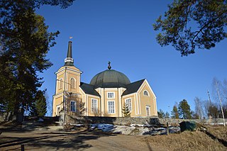
The Orthodox Church of Finland or Finnish Orthodox Church is an autonomous Eastern Orthodox archdiocese of the Ecumenical Patriarchate of Constantinople. The church has a legal position as a national church in the country, along with the Evangelical Lutheran Church of Finland.

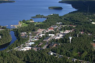
Joensuu is a city in Finland and the regional capital of North Karelia. It is located in the eastern interior of the country and in the Finnish Lakeland. The population of Joensuu is approximately 79,000, while the sub-region has a population of approximately 128,000. It is the 11th most populous municipality in Finland, and the ninth most populous urban area in the country.
Suomussalmi is a municipality in Finland and is located in the Kainuu region about 90 kilometres (56 mi) northeast of Kajaani, the capital of Kainuu and 120 kilometres (75 mi) south of Kuusamo. The municipality has a population of 7,079 (31 October 2024) and covers an area of 5,857.60 square kilometres (2,261.63 sq mi) of which 587.03 km2 (226.65 sq mi) is water. The population density is 1.34 inhabitants per square kilometre (3.5/sq mi). The municipality is unilingually Finnish. Ämmänsaari is the biggest built-up area in the municipality.

Karelia is an area in Northern Europe of historical significance for Russia, Finland, and Sweden. It is currently divided between northwestern Russia and Finland.

Sortavala, previously known as Serdobol (Сердоболь) until 1918, is a town in the Republic of Karelia, Russia, located at the northern tip of Lake Ladoga near the Finnish border, 246 kilometres (153 mi) west of Petrozavodsk, the capital city of the Republic of Karelia. The closest city on the Finnish side of the border is Joensuu, which is located 136 kilometres (85 mi) from Sortavala. In 2021, the population of Sortavala was 19,215.

Huittinen is a town and municipality in Finland. It is located in the Satakunta region, 63 kilometres (39 mi) southeast of Pori and 75 kilometres (47 mi) southwest of Tampere. The town has a population of 9,554 and covers an area of 539.59 square kilometres (208.34 sq mi) of which 6.97 km2 (2.69 sq mi) is water. The population density is 17.94 inhabitants per square kilometre (46.5/sq mi).
Haapajärvi is a town and municipality of Finland.

Heinävesi is a municipality of Finland. It is located in the North Karelia region. The municipality has a population of 2,938 and covers an area of 1,319.58 square kilometres (509.49 sq mi) of which 288.71 km2 (111.47 sq mi) is water. The population density is 2.85 inhabitants per square kilometre (7.4/sq mi). Neighbouring municipalities are Savonlinna, Varkaus, Leppävirta, Tuusniemi, Outokumpu and Liperi. The city of Joensuu is located 81 kilometres (50 mi) northeast of Heinävesi. The municipality is unilingually Finnish.

Kuhmo is a town and a municipality in Finland and is located at the south-eastern corner of the Kainuu region. The municipality has a population of 7,498 and covers an area of 5,456.78 square kilometres (2,106.87 sq mi) of which 649.97 km2 (250.95 sq mi) is water. The population density is 1.56 inhabitants per square kilometre (4.0/sq mi). It shares a border of 120 kilometres (75 mi) with Russia. Neighbouring towns are Hyrynsalmi, Lieksa, Nurmes, Ristijärvi, Sotkamo and Suomussalmi. A neighbour city across the Russian border is Kostomuksha. Vartius, one of the border crossing points between Finland and Russia, is located in northern Kuhmo.

Lieksa is a town and municipality of Finland. It is located in the North Karelia region. The municipality has a population of 10,073 and covers an area of 4,067.60 square kilometres (1,570.51 sq mi) of which 649.14 km2 (250.63 sq mi) is water. The population density is 2.95 inhabitants per square kilometre (7.6/sq mi).

Liperi is a municipality of Finland. It is located in the North Karelia region. Liperi is a community of 11,956 with the growth rate of 83 newcomers in 11 months in 2007. The population density is 16.44 inhabitants per square kilometre (42.6/sq mi). The municipality covers an area of 1,161.23 square kilometres (448.35 sq mi) of which 434.33 km2 (167.70 sq mi) is water.

Nurmes is a town and municipality of Finland, located in the county of North Karelia. The town has a population of 9,003 and covers an area of 1,854.78 square kilometres (716.13 sq mi) of which 253.7 km2 (98.0 sq mi) is water. The population density is 3.75 inhabitants per square kilometre (9.7/sq mi). Neighbouring municipalities are Juuka, Kuhmo, Lieksa, Rautavaara and Sotkamo.

Parikkala is a municipality of Finland located in the province of Southern Finland and is part of the South Karelia region, 97 kilometres (60 mi) from Lappeenranta and 139 kilometres (86 mi) from Joensuu. The town center of Parikkala is about 10 kilometres (6.2 mi) from the Russian border. The municipality has a population of 4,320 and covers an area of 760.71 square kilometres (293.71 sq mi) of which 167.78 km2 (64.78 sq mi) is water. The population density is 7.3 inhabitants per square kilometre (19/sq mi).

Rautjärvi is a municipality in the South Karelia region of Finland. The municipality has a population of 3,018 (31 October 2024) and covers an area of 401.89 square kilometres (155.17 sq mi) of which 50.25 km2 (19.40 sq mi) is water. The population density is 8.59 inhabitants per square kilometre (22.2/sq mi). More than half of Rautjärvi's residents live in Simpele, the administrative center of the municipality.
Rääkkylä is a municipality of Finland. It is located in the province of Eastern Finland and is part of the North Karelia region. The municipality has a population of 1,879, which make it the smallest municipality in North Karelia in terms of population. It covers an area of 699.68 square kilometres (270.15 sq mi) of which 272.01 km2 (105.02 sq mi) is water. The population density is 4.39 inhabitants per square kilometre (11.4/sq mi). The municipality is unilingually Finnish.
Tohmajärvi is a municipality of Finland. It is located in the North Karelia region. The municipality has a population of 3,993 (31 October 2024) and covers an area of 895.36 square kilometres (345.70 sq mi) of which 57.62 km2 (22.25 sq mi) is water. The population density is 4.77 inhabitants per square kilometre (12.4/sq mi). The municipality is unilingually Finnish.

Petkeljärvi National Park is a national park in Ilomantsi in the North Karelia region of Finland. It was established in 1956 and covers 6 square kilometres (2 sq mi). Its specialities are e.g. fortification from the Continuation War, some of which have been renovated, and valuable eskers. The park's vegetation mostly consists of light Scots pine forests. The park, along with Patvinsuo National Park, belongs to the North-Karelian biosphere reserves of UNESCO.

Pogost is a Russian historical term which has had several meanings. In modern Russian, it typically refers to a rural church and graveyard. It has also been borrowed into Latgalian (pogosts), Finnish (pogosta) and Latvian (pagasts), with specific meanings.

Ladoga Karelia is a historical region of Karelia, currently largely in Russia. Today, the term refers to the part of the Republic of Karelia in the Russian Federation comprising the south-west part of the Republic, specifically Lakhdenpokhsky District, Pitkyarantsky District and Sortavala District. This region is on the northern littoral of Lake Ladoga, which borders Olonets Karelia to the East, Leningrad Oblast to the south-west and the North Karelia region of Finland to the west.

Johannes Vasilinpoika Karhapää was a Finnish Karelian teacher and an Eastern Orthodox missionary who was killed by the White Guards during the Finnish Civil War. He was canonized in 2018 as the Holy Martyr and Confessor John of Sonkajanranta.