
The York River is a river in Renfrew County, Hastings County and Haliburton County in Ontario, Canada. The river is in the Saint Lawrence River drainage basin, and flows from the southern extension of Algonquin Provincial Park to the Madawaska River.

The Petawawa River is a river in the Saint Lawrence River drainage basin in Nipissing District and Renfrew County in eastern and northeastern Ontario, Canada. The river flows from Algonquin Provincial Park to the Ottawa River at the town of Petawawa, and is only one of two major tributaries of the Ottawa River to flow completely free. The river's name comes from the Algonquian for "where one hears a noise like this", which refers to its many rapids.

The Bonnechere River is a river in the Saint Lawrence River drainage basin in Nipissing District and Renfrew County in eastern and northeastern Ontario, Canada. The river flows from Algonquin Provincial Park to the Ottawa River east and north of the town of Renfrew. The river's name is thought to come from the French "bonne chère" meaning "good cheer".

The Opeongo River is a river in the Saint Lawrence River drainage basin in Nipissing District in northeastern Ontario, Canada. The river is entirely within Algonquin Provincial Park and Opeongo River Provincial Park, except for a small portion around Victoria Lake, and is a left tributary of the Madawaska River.

The Barron River is a river in the Saint Lawrence River drainage basin in Nipissing District and Renfrew County, Ontario, Canada. It flows from Clemow Lake in northern Algonquin Provincial Park and joins the Petawawa River, whose southern branch it forms, in the municipality of Laurentian Hills, near the municipality of Petawawa.
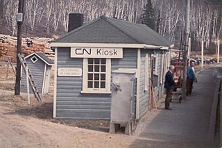
Kiosk is an unincorporated place and former railway point and community in geographic Pentland Township in the Unorganized South Part of Nipissing District in northeastern Ontario, Canada. Kiosk is surrounded by but not within Algonquin Provincial Park, for which it provides a road access point via Ontario Highway 630, and is located on Kioshkokwi Lake on the Amable du Fond River on the right bank of the outlet of that river from the lake and across the river from the unincorporated place of Coristine. The name "Kiosk" is an abbreviated form of the lake's name, which means "lake of many gulls".
The Clyde River is a river in Lanark County in Eastern Ontario, Canada. It is in the Saint Lawrence River drainage basin, is a left tributary of the Mississippi River, and was named after the River Clyde in Scotland.

South Algonquin is a township municipality in Nipissing District, Ontario, Canada. Located south of Algonquin Provincial Park, it is the sole populated portion of the district that lies south of the traditional dividing line between Northern Ontario and Southern Ontario and is closer connected to Renfrew County as opposed to the core portions of Nipissing District.

Lake Traverse is the name of two adjacent unincorporated places, one a former railway point and the other a compact rural community, in geographic White Township in the Unorganized South Part of Nipissing District in northeastern Ontario, Canada. They are both located within Algonquin Provincial Park, the compact rural community on Lake Travers on the Petawawa River and the railway point slightly inland.
Radiant is an unincorporated place and former railway point in geographic Deacon Township in the Unorganized South Part of Nipissing District in northeastern Ontario, Canada. Radiant is located within Algonquin Provincial Park on Radiant Lake on the Petawawa River.

The Crow River is a river in the Saint Lawrence River drainage basin in the Unorganized South Part of Nipissing District in northeastern Ontario, Canada. The river lies entirely within Algonquin Provincial Park and is a right tributary of the Petawawa River.
The Little Madawaska River is a river in the Saint Lawrence River drainage basin in the Unorganized South Part of Nipissing District in northeastern Ontario, Canada. The river is entirely within Algonquin Provincial Park, and is a right tributary of the Petawawa River and not a tributary of the nearby Madawaska River.
The Nipissing River is a river in the Saint Lawrence River drainage basin in the Unorganized South Part of Nipissing District in northeastern Ontario, Canada. The river is entirely within Algonquin Provincial Park, and is a left tributary of the Petawawa River.
The Tim River is a river in the Saint Lawrence River drainage basin in the Unorganized South Part of Nipissing District in northeastern Ontario, Canada. The river is entirely within Algonquin Provincial Park, and is a left tributary of the Petawawa River.
Stuart is the name of an unincorporated place and former railway point in geographic White Township in the Unorganized South Part of Nipissing District in northeastern Ontario, Canada. Stuart is located within Algonquin Provincial Park on Travers Creek.
Kathmore is an unincorporated place and former railway point in geographic Master Township in the Unorganized South Part of Nipissing District in northeastern Ontario, Canada. Kathmore is located within Algonquin Provincial Park on Walker Creek, 500 metres (1,640 ft) upstream of that creek's mouth at the Indian River.
Indian is an unincorporated place and former railway point in the incorporated township of Laurentian Valley in Renfrew County, eastern Ontario, Canada. Indian is located on the Indian River just southeast of the southeast corner of Algonquin Provincial Park.
Coristine is an unincorporated place and former railway point in geographic Pentland Township in the Unorganized South Part of Nipissing District in northeastern Ontario, Canada. Coristine is located within Algonquin Provincial Park on Kioshkokwi Lake on the Amable du Fond River, on the right bank of the outlet of that river from the lake and opposite the settlement of Kiosk.
The Big East River is a river in Muskoka District and Nipissing District in Northeastern Ontario, Canada. The river is in the Great Lakes Basin, is a left tributary of the Muskoka River, and flows from Algonquin Provincial Park to Huntsville.
Depot Creek is a river in Nipissing District in Northeastern Ontario, Canada. It is in the Saint Lawrence River drainage basin, is a tributary of Grand Lake on the Barron River, and lies entirely within Algonquin Provincial Park.
