Border infrastructure along the Sino-Indian border, which has several border areas disputed by both India and China, encompasses irrigation, roads, railways, airports, natural gas and oil pipelines, electricity grids, telecommunications, and broadcasting. In the context of the border tensions between India and China, many of these infrastructure projects in the borderlands are considered strategic in nature. Commentators have noted the infrastructure gap that existed, and still exists, between the infrastructure on the borderlands of India and China. [1] For many decades, the approach taken to the construction of border infrastructure by China and India was significantly different, [2] however, in terms of utilizing the natural resources of the borderlands for the needs of the country, both countries are said to have a similar approach. [3]
The Line of Actual Control (LAC) is the disputed border between India and China, which has led to the ongoing Sino-Indian border dispute. There are designated Border Personnel Meeting Points (BPM Points or BPMP) on LAC, mutually agreed by India and China, for conducting meeting to resolve the dispute. [4]
Chinese Military has an integrated Western Theater Command (WTC) across the whole LAC with India. Western Theater Command also covers provinces of Sichuan, Gansu, Ningxia, Qinghai and Chongqing. [5]
Indian Military has divided the LAC into 3 sectors - the northern sector (some times also called western sector) across Ladakh and the Chinese-held Aksai Chin, the central sector across Himachal Pradesh and Uttrakhand states, and the eastern sector across Sikkim and Arunachal Pradesh states. [6] [7]
China has built several roads along Indian border:
China is constructing the China-Pakistan Economic Corridor (CPEC) in Pakistan-occupied Kashmir which is an area claimed by India. India also claims the nearby Trans-Karakoram Tract (Shaksgam Valley) ceded to China by Pakistan. Pakistan and China have also built the strategic Karakoram Highway, which connects Pakistan-held India-claimed Gilgit to Xinjiang. [15]
China has developed a number of "xiaokang" or "model well-off border defence villages". [16] The number of villages reportedly– range from 624, [16] [17] and 680, [18] [19] to 965. [17] Some of the new Chinese border villages (with claimed location) are as follows:
See the Indian air bases and advanced landing grounds (ALG) along China border.
India has identified the specific Patrol Points with the specified route and the maximum depth up to which Indian troops usually patrol into the disputed territory on LAC. Patrolling points provide a truer sense of the extent of India's limits of actual control. [26] [27] [28]
This section needs expansion. You can help by adding to it. (January 2024) |
Some of that Indian railway projects serving the border with China are:
India has embarked on constructing India-China Border Roads.
Under the 4G Saturation project, the BSNL will set up 20,000 4G towers in 30,000 border villages at the cost of ₹26,000 crore rupees from the Universal Service Obligation Fund. As of May 2023 the project was already underway and it will be completed in 15 months by 31 July 2024. Today, India has about 640,000 villages, of which 575,000 have been covered by mobile telephony and data connectivity, leaving a gap of 65,000 villages without connectivity, of these 40,000 villages are being covered under the border village plan. Under the 4G saturation plan, the government wants to connect 100% villages with 4G services by 2024. [29]
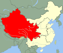
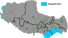
India has two non-overlapping distinct schemes, the Vibrant Village Program (VVP) specifically for the Indian villages on border with China and the Border Area Development Programme (BADP) for Indian villages on border with all the neighboring countries including China, Pakistan, Bangladesh, Myanmar, Nepal, Bhutan, etc. [30]
Vibrant Village Program (VVP) phase-1 has ₹ 4,800 crore (US$600 million), including ₹ 2,500 crore (US$310 million) for the roads alone, centrally sponsored scheme budget for the fy2022-23 to fy2025-26 3 year period to comprehensively develop 662 villages with a population of 142,000 on India-China border in the states of Arunachal Pradesh, Sikkim, Uttarakhand and Himachal Pradesh and the Union Territory of Ladakh. Eventually the scheme will cover all 2,967 villages in 46 blocks of 19 border districts for the comprehensive development in the subsequent phases. The district administrator will prepare the district and village level plans with the help of grampanchayats (elected Village council) in a "hub & spokes" based growth centers model by identifying natural & human resources to develop tourism & eco-agriculture, comprehensive infrastructure including electricity, communications, healthcare, roads, startups, social enterprises, youth and woman entered empowerment, etc to stop the outward migration. NGOs, self help groups (SHG) and cooperatives will also be included. [30]
To boost the astrotourism in India, the government is setting up observatories at Jadhang and some other places under this program. [31]
The Border Area Development Programme (BADP) was initiated in the 1980s along the western border with Pakistan. By June 2020, the scheme covered nearly 400 blocks in 111 border districts in 18 states and union territories. [4] This scheme extends to development projects within 10 km of the border. [note 1] Projects can include roads, bridges, health facilities, primary schools, irrigation, and sports facilities. [4] In 2019–20, the scheme was allotted ₹ 825 crore (equivalent to ₹971 croreorUS$120 million in 2023), while in 2020-21 it was allotted ₹ 784 crore (equivalent to ₹923 croreorUS$120 million in 2023). [4]
In 1997, BADP started in Arunachal Pradesh. It first applied to the Indo-Myanmar Border and in 1998 was extended to the Indo-China and Indo-Bhutan borders. [33] Even after ten years, BADP was unable to provide development to the over 1500 villages in the border blocks of Arunachal Pradesh; "the border blocks are yet to be opened up and are in utter backwardness due to their isolation and inaccessibility". [33] A NITI Aayog evaluation study for the period 2007-2011 and published in 2015 found that while the heads of Gram Panchayats (GPs) gave positive feedback related to BADP, and while people have benefitted in some ways, the requirement of border villages in Arunachal Pradesh were so great that they couldn't be met by BADP in one go: [34]
...of the 21 GPs surveyed, only six were connected by all-weather roads; electricity was available in only seven of them; tap water was available only in five; none of the GPs surveyed had fixed line telephones. Only two of the 21 GPs had PDS shops; some villages were almost 25 km away from these shops. Several villages did not even have primary schools and anganwadi centres.
Arunachal Pradesh has 455 villages under vibrant village scheme. Of these, 135 villages are designated as priority villages, because they are not yet connected by the roads. In January 2024, the central Ministry of Rural Development approved Rs 2,205 crores project to connect these 125 unconnected villages in Arunachal with 105 roads of total distance of 1,022 km. Detailed Project Reports (DPR) are being prepared for these 105 road. Remaining 10 villages are not being considered presently because of issues related to the land acquisition. [35]
District | Block | No of Villages | Pop (2001 census) |
---|---|---|---|
Tawang | Tawang | 37 | 12949 |
Kitpi | 47 | 4853 | |
West Kameng | Nafra | 29 | 13644 |
East Kameng | Bameng | 69 | 9244 |
Chayngtajo | 68 | 10881 | |
Kurung Kumey | Huri-Damin | 32 | 2957 |
Pipsorang | 32 | 2206 | |
Sarli | 36 | 1951 | |
Koloriang | 52 | 4798 | |
Parsi-Parlo | 43 | 3226 | |
Upper Subansiri | Nacho | 65 | 5249 |
Siyum | 48 | 4080 | |
West Siang | Mechuka | 45 | 6244 |
Monigong | 34 | 3025 | |
Kaying-Payum | 25 | 5543 | |
Upper Siang | Tuting | 16 | 5874 |
Singa-Gelling | 18 | 1692 | |
Lower Dibang Valley | Hunli | 41 | 3114 |
Dibang Valley | Anini-Mipi | 38 | 4344 |
Etalin-Maliney | 28 | 1575 | |
Aneli-Arzoo | 34 | 1353 | |
Anjaw | Chaglagam | 42 | 2412 |
Hayuliang | 92 | 10262 | |
Total | 962 | 121476 |
The Line of Actual Control (LAC), in the context of the Sino-Indian border dispute, is a notional demarcation line that separates Indian-controlled territory from Chinese-controlled territory. The concept was introduced by Chinese premier Zhou Enlai in a 1959 letter to Jawaharlal Nehru as the "line up to which each side exercises actual control", but rejected by Nehru as being incoherent. Subsequently, the term came to refer to the line formed after the 1962 Sino-Indian War.
The Border Roads Organisation (BRO) is a statutory body under the ownership of the Ministry of Defence of the Government of India. BRO develops and maintains road networks in India's border areas and friendly neighboring countries. This includes infrastructure operations in 19 states and three union territories and neighboring countries such as Afghanistan, Bhutan, Myanmar, Tajikistan and Sri Lanka. By 2022, BRO had constructed over 55,000 kilometres (34,000 mi) of roads, over 450 permanent bridges with a total length of over 44,000 metres (27 mi) length and 19 airfields in strategic locations. BRO is also tasked with maintaining this infrastructure including operations such as snow clearance.
Tawang is a town and administrative headquarter of Tawang district in the Indian state of Arunachal Pradesh. It lies on NH-13 section of Trans-Arunachal Highway. The town was once the capital of the Tawang Tract, which is now divided into the Tawang district and the West Kameng district. Tawang continues as the headquarters of the former. Tawang is the number one tourist destination of Arunachal Pradesh.
The Ministry of Development of North Eastern Region is a Government of India ministry, established in September 2001, which functions as the nodal Department of the Central Government to deal with matters related to the socio-economic development of the eight States of Northeast India: Arunachal Pradesh, Assam, Manipur, Meghalaya, Mizoram, Nagaland, Tripura and Sikkim. It acts as a facilitator between the Central Ministries/ Departments and the State Governments of the North Eastern Region in the economic development including removal of infrastructural bottlenecks, provision of basic minimum services, creating an environment for private investment and to remove impediments to lasting peace and security in the North Eastern Region.
In 1986–87, a military standoff took place between India and China in the Sumdorong Chu Valley bordering the Tawang district, Arunachal Pradesh and Cona County, Tibet. It was initiated by China moving a company of troops to Wangdung, a pasture to the south of Sumdorong Chu that India believed to be its territory. The Indian troops stood their ground on the neighbouring Longro La ridge and both the sides moved a large number of troops to the border. The crisis was diffused after the visit of Indian External Affairs minister to Beijing in May 1987. The standoff gave rise to fears of escalation. Subsequently, India and China formulated agreements for managing future border tensions.
The Sino-Indian border dispute is an ongoing territorial dispute over the sovereignty of two relatively large, and several smaller, separated pieces of territory between China and India. The first of the territories, Aksai Chin, is administered by China as part of the Xinjiang Uyghur Autonomous Region and Tibet Autonomous Region and claimed by India as part of the union territory of Ladakh; it is mostly uninhabited high-altitude wasteland in the larger regions of Kashmir and Tibet and is crossed by the Xinjiang-Tibet Highway, but with some significant pasture lands at the margins. The other disputed territory is south of the McMahon Line, in the area formerly known as the North-East Frontier Agency and now called Arunachal Pradesh which is administered by India. The McMahon Line was part of the 1914 Simla Convention signed between British India and Tibet, without China's agreement. China disowns the agreement, stating that Tibet was never independent when it signed the Simla Convention.
Kobresia is a genus of plants in the sedge family. They are sometimes called bog sedges. These perennial sedges are quite similar to Carex species in appearance. The genus is widespread across much of Europe, Asia and North America, with many species native to the Himalayas.
The Indian Himalayan Region is the section of the Himalayas within the Republic of India, spanning thirteen Indian states and union territories, namely Ladakh, Jammu and Kashmir, Himachal Pradesh, Uttarakhand, Sikkim, West Bengal, Manipur, Meghalaya, Mizoram, Nagaland, Tripura, Assam, and Arunachal Pradesh. The region is responsible for providing water to a large part of the Indian subcontinent and contains various flora and fauna.
There are several disputed territories of India. A territorial dispute is a disagreement over the possession or control of land between two or more states or over the possession or control of land by a new state and occupying power after it has conquered the land from a former state no longer currently recognized by the new state.
The Bhanupli–Leh line is an under-construction electrified railway track connecting Bhanupli in Punjab state to Leh in Ladakh union territory of India. Once complete, the 489 km (304 mi) long, 1,676 mm wide gauge all-weather track will reduce travel time from New Delhi to Leh to 10 hours. Passing through seismic zone IV and V at an elevation of 600 m (2,000 ft) to 5,360 m (17,590 ft) above sea level, the line will surpass China's Qinghai–Tibet railway to become the highest railway in the world upon completion.
Arunachal Frontier Highway (AFH), officially notified as the National Highway NH-913 and also called Bomdila-Vijaynagar Highway (BVH), connecting Bomdila Airstrip ALG & HQ in northwest to Vijaynagar Airstrip ALG & HQ in southeast via Nafra HQ-Sarli HQ-Huri Helipad ALG & HQ-Nacho HQ-Mechuka Airstrip ALG & HQ-Monigong HQ-Jido -Hunli HQ-Hayuliang Airstrip ALG HQ-Chenquenty-Hawai HQ-Miao HQ including 800 km greenfield section and network of new tunnels & bridges, is a 2-lane paved-shoulder under-construction national highway along the India-China LAC-McMahon Line border in the Indian state of Arunachal Pradesh. The 1,748 km-long (1,086 mi) highway itself will cost ₹27,000 crore and total cost including 6 additional inter-corridors is ₹40,000 crore. In some places, this highway will run as close as 20 km from the LAC. To be constructed by MoRTH in 9 packages, all packages will be approved by the end of fy 2024-25 and construction will be completed in 2 years by 31 March 2027. Of the total route, 800km is greenfield, rest brownfield will be upgraded and tunnels will be built. This highway in the north & east Arunachal along the China border, would complement the Trans-Arunachal Highway and the Arunachal East-West Corridor as major highways spanning the whole state, pursuing the Look East connectivity policy.
The Western Theater Command is one of the five theater commands of the People's Liberation Army, founded on 1 February 2016.
XVII Corps is the first mountain strike corps of India which has been built as a quick reaction force and as well as counter offensive force against China along LAC. Its headquarters are located at Panagarh in West Bengal under Eastern Command. It is also known as Brahmastra Corps.
Eastern South Asia is a geographical area in the Southern Asian subregion, precisely the eastern region of the subcontinent. It includes the countries of Bangladesh, Bhutan, Nepal and India. Geographically, it lies between the Eastern Himalayas and the Bay of Bengal. Two of the world's largest rivers, the Ganges and the Brahmaputra, flow into the sea through the Bengal region. The region includes the world's highest mountainous terrain and the world's largest delta, and has a climate ranging from alpine and subalpine to subtropical and tropical. Since Nepal, Bhutan, and northeast India are landlocked, the coastlines of Bangladesh and East India serve as the principal gateways to the region.
Border Personnel Meeting points are locations along the disputed Sino-Indian territories on Line of Actual Control (LAC) where the armies of both countries hold ceremonial and practical meetings to resolve border issues and improve relations. While border meetings have been held since the 1990s, the first formal Border Personnel Meeting point was established in 2013. There are five meeting points: two in the Indian Union Territory of Ladakh, one in Sikkim, and two in Arunachal Pradesh in India's Central and Eastern sectors.
Beginning on 5 May 2020, Chinese and Indian troops engaged in aggressive melee, face-offs, and skirmishes at locations along the Sino-Indian border, including near the disputed Pangong Lake in Ladakh and the Tibet Autonomous Region, and near the border between Sikkim and the Tibet Autonomous Region. Additional clashes also took place at locations in eastern Ladakh along the Line of Actual Control (LAC).
India–China Border Roads is a Government of India project for developing infrastructure along the Sino-Indian border by constructing strategic roads, including bridges and tunnels. The ICBR project is largely in response to Chinese infrastructure development along the borderlands with India.
The Five Fingers of Tibet is a Chinese foreign policy attributed to Mao Zedong that considers Tibet to be China's right hand palm, with five fingers on its periphery: Ladakh, Nepal, Sikkim, Bhutan, and North-East Frontier Agency, that it is China's responsibility to "liberate" these regions.
Zemithang or Pangchen, is a village and the headquarters of an eponymous circle in the Tawang district of Indian state of Arunachal Pradesh. It is on the bank of the Nyamjang Chu river, which originates in Tibet and enters India from the north near the locality called Khinzemane.