Langeberg Municipality is a local municipality located within the Cape Winelands District Municipality in the Western Cape province of South Africa. As of 2011 it had a population of 97,724. Its municipality code is WC026.

Breede Valley Municipality is a local municipality located within the Cape Winelands District Municipality, in the Western Cape province of South Africa. As of 2007, it had a population of 166,825. Its municipality code is WC025.
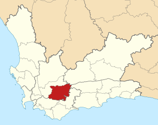
Hessequa Local Municipality is a municipality located in the Western Cape Province of South Africa. It is flanked by the lower Breede River to the west and the Gourits River to the east. As of 2011 the population was 52,642. Its municipality code is WC042. The name Hessequa, meaning "people of the trees", refers to the tribe of indigenous Khoikhoi people.

Swellendam Municipality is a municipality located in the Western Cape Province of South Africa. As of 2011 it had a population of 35,916. Its municipality code is WC034.

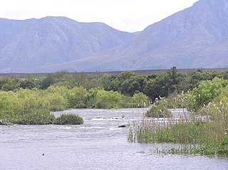
The Breede River, also known as Breë River, is a river in the Western Cape Province of South Africa. Travelling inland north from the city of Cape Town, the river runs in a west to east direction. The surrounding western mountains formed the first continental divide experienced by European settlers in the 18th century. The Titus River and Dwars River become the Breë River.
João Infante was a Portuguese explorer of the African coast. He accompanied Bartolomeu Dias in his journey around the Cape of Good Hope in 1487/1488 by leading a second caravel, the São Pantaleão.

Bontebok National Park is a species-specific national park in South Africa. It was established in 1931 to ensure the preservation of the Bontebok. It is the smallest of South Africa's 18 National Parks, covering an area of 27.86 km2 The park is part of the Cape Floristic Region, which is a World Heritage Site.
Breede River Valley is a region of Western Cape Province, South Africa known for being the largest fruit and wine producing valley in the Western Cape, as well as South Africa's leading race-horse breeding area. It is part of the Boland bordering on becoming Little Karoo towards the east.

The wine regions of South Africa were defined under the "Wine of Origin" act of 1973. Mirroring the French Appellation d'origine contrôlée (AOC) system, all South African wines listing a "Wine of Origin" must be composed entirely of grapes from its region. The "Wine of Origins" (WO) program mandates how wine regions of South Africa are defined and can appear on wine labels. While some aspects of the WO are taken from the AOC, the WO is primarily concerned with accuracy in labeling. As a result, the WO does not place adjunct regulations on wine regions such as delineating permitted varieties, trellising methods, irrigation techniques, and crop yields.

The Sonderend River, also known as the Riviersonderend, is a main tributary of the Breede River, located in Western Cape Province, South Africa. The village of Riviersonderend is believed to have taken its name from the river.

Buffeljagsriver is a river that originates where two other rivers meet, one being the Grootvadersbos River and the other the Tradou River. The confluence is just east of a small town, Suurbraak, Western Cape province. The Tredouw's Pass is situated just north of this meeting point. To the west of the town the river flows into the Buffeljags Dam, and the river then heads south to join the Breede River, not far from the Bontebok National Park.
Bonnievale is a settlement in the Cape Winelands District Municipality in the Western Cape province of South Africa.

De Doorns is situated in the Breede Valley Local Municipality, Cape Winelands District Municipality in the Western Cape province of South Africa.

Touws River is a small railway town of 6,800 people in the Western Cape province of South Africa. It is located on the river of the same name, about 160 kilometres (100 mi) north-east of Cape Town. The Touwsrivier CPV Solar Project is located just outside of the town and supplies 50 MW to the national electrical grid.

Wolseley is a small town in the upper Breede River Valley region of the Western Cape province of South Africa. In the 2011 Census it had a population of 1,528 people. It is located 90 kilometres (60 mi) northeast of Cape Town, in the Land van Waveren valley between the Waterval Mountains to the west and the Witzenberg Mountains to the east.
The Breede River Canoe Marathon is an annual South African K2 (doubles) race down the Breede River from Robertson to Swellendam in the Western Cape over a distance of 75 km. The two-day race through scenic wine country, was first run in 1968, and is usually held during September when good rains ensure reasonable water levels.

Port Beaufort is a settlement in Garden Route District Municipality in the Western Cape province of South Africa.
Witsand is a small coastal town situated at the mouth of the Breede River in the Western Cape, South Africa. It is a good fishing area and is widely considered to be the whale nursery of the South African coastline. Witsand has seen some of the largest bull sharks caught in the Breede River, although no shark attacks on people have been recorded to date. It is also popular for kitesurfing and windsurfing due to the summer South-Easter.. Every year Witsand serves as the finish for the Heidelberg to Witsand marathon and half-marathon road running race.

The Boland is a region of the Western Cape province of South Africa, situated to the northeast of Cape Town in the middle and upper courses of the Berg and Breede Rivers, around the Boland Mountains of the central Cape Fold Belt. It is sometimes also referred to as the Cape Winelands because it is the primary region for the making of Western Cape wine.

Malgas is a settlement on the right (southwest) bank of the Breede River in the Overberg region of the Western Cape. It is situated 25 kilometres north-west of the Breede River mouth at Witsand, and 30 kilometres south-east of Swellendam. "Malgas" is the Afrikaans for gannet. The word "malgas" is probably an adaptation of the Portuguese mangas de velludo, "velvet sleeves", referring to the Cape gannet with its black-tipped wings. According to the 2011 census, Malgas has a population of 44 people in 20 households. https://forebears.io/surnames/malagas It is well known for the "pont", a man-hauled pontoon cable ferry across the Breede River, which is the last of its type in South Africa. The man hauled ferry is currently being replaced by a motor driven ferry, which is sad, but the volume of traffic is fairly substantial so the replacement is probably due. The new ferry is a huge yellow steel pontoon with a massive diesel engine.


