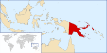
Port Moresby, also referred to as Pom City or simply Moresby, is the capital and largest city of Papua New Guinea. It is one of the largest cities in the southwestern Pacific outside of Australia and New Zealand. It is located on the shores of the Gulf of Papua, on the south-western coast of the Papuan Peninsula of the island of New Guinea. The city emerged as a trade centre in the second half of the 19th century. During World War II, it was a prime objective for conquest by the Imperial Japanese forces during 1942–43 as a staging point and air base to cut off Australia from Southeast Asia and the Americas.

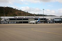
Air Niugini Limited is the national airline of Papua New Guinea, based in Air Niugini House on the property of Jacksons International Airport, Port Moresby. It operates a domestic network from Port Moresby to 12 major airports while its subsidiary company, Link PNG, operates routes to minor airports. It also operates international services in Asia, Oceania, and Australia on a weekly basis. Its main base is Jacksons International Airport, which is located in 7 Mile, Port Moresby, Papua New Guinea. Niugini is the Tok Pisin word for New Guinea.

Mount Hagen is the third largest city in Papua New Guinea, with a population of 46,250. It is the capital of the Western Highlands Province and is located in the large fertile Wahgi Valley in central mainland Papua New Guinea, at an elevation of 1,677 m (5,502 ft).
PNG Air is an airline based on the grounds of Jacksons International Airport, Port Moresby, Papua New Guinea. It operates scheduled domestic and international flights, as well as contract corporate charter work. Its main base is Jacksons International Airport.

Lae Nadzab Airport is a regional airport located at Nadzab 42 kilometres (26 mi) outside Lae, Morobe Province, Papua New Guinea along the Highlands Highway. It is served by both private and regional aircraft with domestic flights. The airport replaced the Lae Airfield in 1977.
Buka Airport is an airport serving Buka Island in the Autonomous Region of Bougainville in Papua New Guinea.
Daru Airport is an airport serving Daru, the capital of the Western Province in Papua New Guinea.
Hoskins Airport is an airport in Hoskins in Papua New Guinea. The airport serves Kimbe - the capital of West New Britain province. Mount Pago is 16 km from the airport.

Kagamuga International Airport is the second biggest airport in Papua New Guinea (PNG) and is located in the Waghi Valley, 13 km north-east of Mount Hagen, the capital of Western Highlands Province of Papua New Guinea. The airport has one terminal and two runways, and is operated by its owner, National Airports Corporation of Papua New Guinea.

Tufi Airport is an airport in Tufi, Papua New Guinea built in the 1960s by the Australian Army. It consists of a single 920 by 30 meters unpaved runway along a 059-239 degree axis. There is no control tower and refueling is not available. Air Niugini flights are typically scheduled on Monday (POM-PNP-TFI-POM) and Friday (POM-TFI-PNP-POM). Tropic Air also schedules irregular cargo and passenger charter flights.
Lae Airfield is a former World War II airfield and later, civilian airport located at Lae, Morobe Province, Papua New Guinea. The airport was closed in the 1980s, in favour of Lae Nadzab Airport, which was able to accommodate larger jet aircraft. The airport was also known as Lae Drome or Lae Aerodrome.
Wards Airfield is a former World War II airfield near Port Moresby, Papua New Guinea. The airfield was abandoned after the war and was developed into the Waigani area of Port Moresby.

Kila Airfield is a former World War II airfield near Port Moresby, Papua New Guinea. It was part of a multiple-airfield complex in the Port Moresby area, located north of Joyce Bay, three miles from the town of Port Moresby near the village of Kila Kila.
Berry Airfield is a former World War II airfield near Port Moresby, Papua New Guinea. It was part of a multiple-airfield complex in the Port Moresby area, located 12 miles (19 km) inland from Port Moresby.
Schwimmer Airfield is a former World War II airfield near Port Moresby, Papua New Guinea. It was part of a multiple-airfield complex in the Port Moresby area, located north of the Laloki River.
Rogers Airfield is a former World War II airfield near Redscar Bay, Papua New Guinea. It was part of a multiple-airfield complex in the Port Moresby area, located 30 miles (48 km) north-west of Port Moresby by air, near Rorona.
Fishermans Airfield is a former World War II airfield near Port Moresby, Papua New Guinea. It was part of a multiple-airfield complex in the Port Moresby area, located offshore of Port Moresby. The island's name is derived from the names of the island's two villages - Dag and Ugo. It is also known as Fisherman's Island.
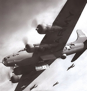
The Port Moresby Airfield Complex was a World War II military airfield complex, built near Port Moresby in the Territory of Papua and New Guinea. It was used during the Battle of New Guinea as a base of Allied air operations primarily in 1942 and early 1943. It later became a support base as the battle moved to the north and western part of New Guinea. It was closed and the facility turned over to civil authorities after the end of the war in September 1945.
The Papua New Guinea Accident Investigation Commission (PNGAIC) is an agency of the Government of Papua New Guinea (GoPNG) investigating aviation accidents and serious incidents. The office is located in Level 1, NAQIA Building, Morea-Tobo Road, 6 Mile, National Capital District.