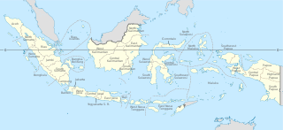
Provinces of Indonesia are the 38 administrative divisions of Indonesia and the highest tier of the local government. Provinces are further divided into regencies and cities, which are in turn subdivided into districts (kecamatan).

Central Sulawesi is a province of Indonesia located at the centre of the island of Sulawesi. The administrative capital and largest city is located in Palu. The 2010 census recorded a population of 2,635,009 for the province, and the 2020 Census recorded 2,985,734, of whom 1,534,706 were male and 1,451,028 were female. The official estimate as at mid 2022 was 3,066,143. Central Sulawesi has an area of 61,605.72 km2 (23,786 sq mi), the largest area among all provinces on Sulawesi Island, and has the second-largest population on Sulawesi Island after the province of South Sulawesi. It is bordered by the provinces of Gorontalo to the north, West Sulawesi, South Sulawesi and South East Sulawesi to the south, by Maluku to the east, and by the Makassar Strait to the west. The province is inhabited by many ethnic groups, such as the Kaili, Tolitoli, etc. The official language of the province is Indonesian, which is used for official purposes and inter-ethnic communication, while there are several indigenous language spoken by the Indigenous peoples of Central Sulawesi. Islam is the dominant religion in the province, followed by Christianity which is mostly adhered to by the people in the eastern part of the province.

West Kalimantan is a province of Indonesia. It is one of five Indonesian provinces comprising Kalimantan, the Indonesian part of the island of Borneo. Its capital city is Pontianak. The province has an area of 147,307 km2, and had a population of 4,395,983 at the 2010 Census and 5,414,390 at the 2020 Census; the official estimate as at mid 2022 was 5,541,376. Ethnic groups include the Dayak, Malay, Chinese, Javanese, Bugis, and Madurese. The borders of West Kalimantan roughly trace the mountain ranges surrounding the vast watershed of the Kapuas River, which drains most of the province. The province shares land borders with Central Kalimantan to the southeast, East Kalimantan to the east, and the Malaysian territory of Sarawak to the north.

Natuna Regency is an islands regency located in the northernmost part of the Province of Riau Islands, Indonesia. It contains at least 154 islands, of which 127 of them are reported as uninhabited. This archipelago, with a land area of 1,978.31 km2 out of a total area of 264,198.37 km2 area, contains 15 districts, including the island district of Pulau Laut, Bunguran/Greater Natuna Island, the island district of Pulau Tiga, the island district of Midai, the island district of Subi, and the island district of Serasan.

Bandung Regency is an administrative landlocked regency located to the south, southeast, east and northeast of the city of Bandung. The northern parts of the Bandung Regency are effectively part of the Bandung Metropolitan Area, with the southern third being less urbanized and jutting upwards from the Valley, though not as sharply as the mountain range to the immediate north of Bandung. The Regency is part of the Indonesian province of West Java, and is situated about 75 miles southeast of Jakarta. The town of Soreang is the regency seat.
A regency, sometimes incorrectly referred to as a district, is an administrative division of Indonesia, directly under a province and on the same level with city (kota). Regencies are divided into districts.
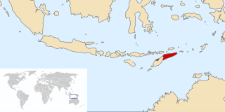
East Timor was a de facto province of Indonesia that existed between 1976 and 1999 during the Indonesian occupation of East Timor. Its territory corresponded to the previous Portuguese Timor and to the present-day independent country of Timor-Leste.

Sleman Regency is an Indonesian regency on the island of Java. It is located in the north of the Yogyakarta Special Administrative Region, Indonesia, and has an area of 574.82 square kilometres (221.94 sq mi), with a population of 1,093,110 at the 2010 Census and 1,125,804 at the 2020 Census. Its capital is the town of Sleman. The current regent is Kustini Sri Purnomo.

Boyolali is a regency in the eastern part of Central Java province in Indonesia. It covers an area of 1,080.93 km2, and had a population of 930,531 at the 2010 census and 1,062,713 at the 2020 census; the official estimate as at mid 2022 was 1,079,952, comprising 543,113 males and 536,839 females.
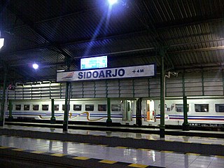
Sidoarjo Regency is a regency in East Java, Indonesia. It is bordered by Surabaya city and Gresik Regency to the north, by Pasuruan Regency to the south, by Mojokerto Regency to the west and by the Madura Strait to the east. It has an area of 719.34 km2, making it the smallest regency in East Java.

Bogor Regency is a landlocked regency (kabupaten) of West Java, Indonesia, south of DKI Jakarta. Covering an area of 2,986.20 km2, it is considered a bedroom community for Jakarta, and was home to 5,427,068 people at the 2020 census. The official estimate as at mid 2022 was 5,566,838. Cibinong serves as the regency seat.
Sukoharjo Regency is a regency in the Central Java province in Indonesia. It covers an area of 493.23 km2 and had a population of 824,238 at the 2010 Census and 907,587 at the 2020 Census; the official estimate as at mid 2022 was 916,627. Its capital is Sukoharjo, about 10 km south from Surakarta. This regency is bordered by the city of Surakarta in the north, Karanganyar Regency in the east, Wonogiri Regency and Yogyakarta in the south as well as Klaten Regency in the west. The regency is part of the metropolitan zone of Surakarta, which is known as Subosukawonosraten.

Brebes is a regency in the northwestern part of Central Java province in Indonesia. It covers an area of 1,769.2km2, and it had a population of 1,733,869 at the 2010 Census and 1,978,759 at the 2020 Census; the official estimate as at mid 2022 was 2,010,617. Its capital is the town of Brebes in the northeast corner of the regency, immediately adjacent to the neighbouring city of Tegal.

Postal codes in Indonesia, known in Indonesian as kode pos consist of 5 digits.

Badung is a regency of Bali, Indonesia. Its regency seat is in the upland town of Mangupura. It covers districts to the west of the provincial capital of Denpasar, and it has a land area of 418.52 km2.

Gresik Regency is a regency within East Java Province of Indonesia. As well as a large part of the Surabaya northern and western suburbs, it includes the offshore Bawean Island, some 125 km to the north of Java and Madura. The regency's administrative centre is the town of Gresik, about 25 km to the northwest of Surabaya. Gresik Regency is also part of Gerbangkertosusila, the metropolitan region of Surabaya.

Bahau people is a sub-ethnic group of the Dayak people who inhabit West Kutai Regency (9.3%), East Kalimantan, Indonesia.
The term district, in the context of Indonesia, refers to the third-level administrative subdivision, below regency or city. The local term kecamatan is used in the majority of Indonesian areas. The term distrik is used in provinces in Papua. In the Special Region of Yogyakarta, the term kapanewon is used for districts within the regencies, while the term kemantren is used for districts within Yogyakarta, the province's only city. According to Statistics Indonesia, there are a total of 7,252 districts in Indonesia as at 2019, subdivided into 83,820 administrative villages.
A regency seat is a capital or seat of government of a regency in Indonesia. It is roughly equivalent of county seat in the United States or county town in the United Kingdom. Legally, regency seats are not administrative subdivisions of Indonesia and have no official boundaries. A regency seat may occupy an entire district, a part of district, or several districts.

Central Papua, officially the Central Papua Province is an Indonesian province located in the central region of Western New Guinea. It was formally established on 11 November 2022 from the former eight western regencies of the province of Papua. It covers an area of 61,072.92 km2 and had an officially estimated population of 1,430,951 in mid 2022. It is bordered by the Indonesian provinces of West Papua to the west, province of Papua to the north, and by Highland Papua and South Papua to the east. The designated administrative capital is located in Nabire Regency.


