Johannes V. Jensen Land

Last updated
Johannes V. Jensen Land
Operational Navigation Chart A-5, 3rd edition.jpg
Map of part of Ellesmere Island and far Northern Greenland.
Greenland edcp relief location map.jpg
Cercle rouge 100%25.svg
Location of Johannes V. Jensen Land
Country Greenland
Zone Northeast Greenland National Park
Dimensions
  Length105 km (65 mi)
  Width55 km (34 mi)
Elevation
1,890 m (6,200 ft)
Population
  TotalUninhabited

Johannes V. Jensen Land is an area in Peary Land, Northern Greenland. Administratively it lies in the Northeast Greenland National Park zone. The area is remote and currently uninhabited.

Contents

Johannes V. Jensen Land is the northernmost region on Earth. [1]

History

This extreme northern area was sparsely inhabited about 2,400 years ago. Its inhabitants were people dependent on hunting muskoxen for survival. The ruins near the head of Frigg Fjord are the northernmost remains of settlements in human history. [2]

This region was named after Danish author Johannes V. Jensen (1902–1973) who was awarded the Nobel Prize in Literature in 1944.

Geography

Johannes V. Jensen Land is a mountainous region, with the Roosevelt Range running across it. Its subranges, the H. H. Benedict Range and Daly Range, rise on the eastern side. [3]

It is bound to the north by the Lincoln Sea and the Wandel Sea and to the south by the Frederick E. Hyde Fjord. The northernmost point is Cape Morris Jesup. To the west lie Gertrud Rask Land and Roosevelt Land. Its easternmost point is Cape Ole Chiewitz, a headland jutting out into the Wandel Sea to the northeast of the mouth of Frederick E. Hyde Fjord and to the southeast of Cape Bridgman. [4]

There are several glaciers in Johannes V. Jensen Land, such as the Malcantone Glacier, the Sif Glacier, the Moore Glacier and the Bertelsen Glacier. [5]

Owing to a structural continuum in the mountains between Johannes V. Jensen Land in the east and Nansen Land in the west, American geologist William E. Davies called the wider range the "Nansen-Jensen Alps" in a work he published in 1972. [6]

Satellite image of the northern end of Greenland. Greenland.A2004208.1810.250m.jpg
Satellite image of the northern end of Greenland.

Bibliography

Related Research Articles

<span class="mw-page-title-main">Cape Morris Jesup</span> Headland in northern Greenland

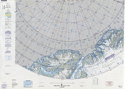
Cape Morris Jesup is a headland in Peary Land, Greenland.

<span class="mw-page-title-main">Peary Land</span> Peninsula in northern Greenland

Peary Land is a peninsula in northern Greenland, extending into the Arctic Ocean. It reaches from Victoria Fjord in the west to Independence Fjord in the south and southeast, and to the Arctic Ocean in the north, with Cape Morris Jesup, the northernmost point of Greenland's mainland, and Cape Bridgman in the northeast.

<span class="mw-page-title-main">Frederick E. Hyde Fjord</span> Body of water

Frederick E. Hyde Fjord is a fjord in Peary Land, far northern Greenland.

<span class="mw-page-title-main">Peary Arctic Club</span>

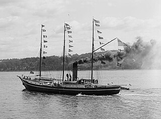
The Peary Arctic Club was an American-based club with the goal of promoting the Arctic expeditions of Robert Peary (1856–1920).

<span class="mw-page-title-main">Cape Bridgman</span>

Cape Bridgman is a headland in the Wandel Sea, Arctic Ocean, northeast Greenland.

De Long Fjord is a fjord system in Peary Land, northern Greenland. To the northwest, the fjord opens into the Lincoln Sea of the Arctic Ocean. It is part of the Northeast Greenland National Park.

<span class="mw-page-title-main">Sands Fjord</span> Fjord in northern Greenland

Sands Fjord is a fjord in Peary Land, northern Greenland. To the north, the fjord opens into the Lincoln Sea of the Arctic Ocean. Administratively it belongs to the Northeast Greenland National Park.

<span class="mw-page-title-main">Hunt Fjord</span> Body of water

Hunt Fjord is a fjord in Peary Land, northern Greenland. To the north the fjord has its mouth in the Lincoln Sea of the Arctic Ocean. Administratively it belongs to the Northeast Greenland National Park.

<span class="mw-page-title-main">Bliss Bay</span> Body of water

Bliss Bay is a bay in the Wandel Sea, Northern Greenland. The area of the bay is uninhabited. Administratively Bliss Bay and its surroundings belong to the Northeast Greenland National Park.

<span class="mw-page-title-main">Roosevelt Range</span>

The Roosevelt Range or Roosevelt Mountains is a mountain range in Northern Greenland. Administratively this range is part of the Northeast Greenland National Park. Its highest peak is the highest point in Peary Land.

<span class="mw-page-title-main">Frigg Fjord</span> Body of water

Frigg Fjord is a fjord in Peary Land, far northern Greenland.

<span class="mw-page-title-main">H. H. Benedict Range</span> Mountain range in northern Greenland

The H. H. Benedict Range or H. H. Benedict Mountains is a mountain range in Peary Land, Northern Greenland. Administratively this range is part of the Northeast Greenland National Park.

<span class="mw-page-title-main">Daly Range</span>

The Daly Range or Daly Mountains is a mountain range in Peary Land, Northern Greenland. Administratively this range is part of the Northeast Greenland National Park.

<span class="mw-page-title-main">A. Harmsworth Glacier</span> Glacier in northern Greenland

A. Harmsworth Glacier or Alfred Harmsworth Glacier is a glacier in northern Greenland. Administratively it belongs to the Northeast Greenland National Park.

<span class="mw-page-title-main">Constable Bay</span> Body of water

Constable Bay is a bay in the Wandel Sea, Northern Greenland. Administratively Constable Bay and its surroundings belong to the Northeast Greenland National Park.

<span class="mw-page-title-main">Nansen Land</span>

Nansen Land is a peninsula in far northwestern Greenland. It is a part of the Northeast Greenland National Park.

<span class="mw-page-title-main">Wyckoff Land</span>

Wyckoff Land is an area or peninsula in Peary Land, Northern Greenland.

Cape Clarence Wyckoff, also known as Cape Wyckoff, is a broad headland in the Wandel Sea, Arctic Ocean, northernmost Greenland. Administratively it is part of the Northeast Greenland National Park.

<span class="mw-page-title-main">Moore Glacier</span> Glacier in northern Greenland

Moore Glacier is a glacier in northern Greenland. Administratively it belongs to the Northeast Greenland National Park. Between 2006 and 2010 there was an automatic weather station in the glacier.

<span class="mw-page-title-main">Roosevelt Land</span>

Roosevelt Land is a peninsula in far northern Greenland. It is a part of the Northeast Greenland National Park.

References

  1. Google Earth
  2. Bjarne Grønnow, Jens Fog Jensen: The Northernmost Ruins of the Globe. Eigil Knuth’s Archaeological Investigations in Peary Land and Adjacent Areas of High Arctic Greenland (= Man & Society. Vol. 29). Museum Tusculanums Forlag, Københavns Universitet, Copenhagen 2003, ISBN   978-87-635-3065-1 pp. 219–237
  3. "Roosevelt Range". Geographical Items on North Greenland Encyclopedia Arctica vol.14-0639. Retrieved 15 June 2019.
  4. Prostar Sailing Directions 2005 Greenland and Iceland Enroute, p. 129
  5. "Johannes V. Jensen Land". Mapcarta. Retrieved 21 July 2019.
  6. W. E. Davies, Landscape of Northern Greenland 1972

Coordinates: 83°20′N32°0′W / 83.333°N 32.000°W / 83.333; -32.000