
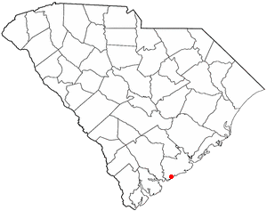
Rockville is a town in Charleston County, South Carolina, United States, that was founded in 1784. The population was 134 at the 2010 census. Rockville is part of the Charleston-North Charleston-Summerville metropolitan area.
Seabrook Island, formerly known as Simmons Island, is a barrier island in Charleston County, South Carolina, United States. The population was 1,714 at the 2010 census, up from 1,250 in 2000.

Drayton Hall is an 18th-century plantation house located on the Ashley River about 15 miles (24 km) northwest of Charleston, South Carolina, and directly across the Ashley River from North Charleston, west of the Ashley in the Lowcountry. An example of Palladian architecture in North America and the only plantation house on the Ashley River to survive intact through both the Revolutionary and Civil wars, it is a National Historic Landmark.

Johns Island is an island in Charleston County, South Carolina, United States, and is the largest island in the state of South Carolina. Johns Island is bordered by the Wadmalaw, Seabrook, Kiawah, Edisto, Folly, and James islands; the Stono and Kiawah rivers separate Johns Island from its border islands. It is the fourth-largest island on the US east coast, surpassed only by Long Island, Mount Desert Island and Martha's Vineyard. Johns Island is 84 square miles (220 km2) in area, with a population of 21,500.

Magnolia Plantation and Gardens is a historic house with gardens located on the Ashley River at 3550 Ashley River Road west of Ashley, Charleston County, South Carolina. It is one of the oldest plantations in the South, and listed on the National Register of Historic Places. Magnolia Plantation is located near Charleston and directly across the Ashley River from North Charleston. The house and gardens are open daily; an admission fee is charged.

The William Seabrook House, also known as the Seabrook is a plantation house built about 1810 on Edisto Island, South Carolina, United States, southwest of Charleston. It is located off Steamboat Landing Road Extension close to Steamboat Creek about 0.7 mi (1.1 km) from Steam Boat Landing. It was named to the National Register of Historic Places on May 6, 1971.

South Carolina Highway 700 (SC 700) is a 20.380-mile (32.798 km) state highway in the U.S. state of South Carolina. Known for most of its length as Maybank Highway, the state highway travels from a dead end in Rockville east to U.S. Route 17 (US 17) in Charleston. SC 700 connects Charleston with James Island, Johns Island, and Wadmalaw Island in southwestern Charleston County.

Brookland Plantation is a large plantation along Shingle Creek on Edisto Island, South Carolina.

Botany Bay Heritage Preserve & Wildlife Management Area is a state preserve on Edisto Island, South Carolina. Botany Bay Plantation was formed in the 1930s from the merger of the Colonial-era Sea Cloud Plantation and Bleak Hall Plantation. In 1977, it was bequeathed to the state as a wildlife preserve; it was opened to the public in 2008. The preserve includes a number of registered historic sites, including two listed in the National Register of Historic Places: a set of three surviving 1840s outbuildings from Bleak Hall Plantation, and the prehistoric Fig Island shell rings.

Marshlands Plantation House, in Charleston, South Carolina, is an historic plantation house that was built in 1810 and listed in the National Register of Historic Places on March 30, 1973. It is a 2+1⁄2-story Federal-style plantation home. The house was relocated in the 1960s from its original location on the site of the United States Navy Shipyard. The Navy had announced it would have to demolish the empty house if it could not be relocated with the $15,000 the Navy had set aside for the purpose. The City of Charleston took temporary possession of the house, transferring it to the College of Charleston which relocated it for preservation to James Island.
The Arnoldus Vander Horst House is a plantation house on Kiawah Island, South Carolina. It is named for Arnoldus Vanderhorst, who was a governor of South Carolina.
Cassina Point was built in 1847 for Carolina Lafayette Seabrook and her husband, James Hopkinson. Carolina Seabrook was the daughter of wealthy Edisto Island planter William Seabrook. William Seabrook had hosted the General Lafayette in 1825 at his nearby home at the time of Carolina's birth. Seabrook gave Lafayette the honor of naming the newborn child, and the general selected Carolina and Lafayette. When Carolina Seabrook married James Hopkinson, they built Cassina Point on the land given to them by William Seabrook.

Lewisfield Plantation is a historic plantation house located near Moncks Corner, Berkeley County, South Carolina. It was built about 1774, and is a 2 1/2-half story clapboard dwelling. It is supported by a high brick foundation that encloses a raised basement. It has a five bay wide verandah supported by six slender Doric order columns. Records show over 100 slaves were held in bondage on the plantation as of 1835.

Ashley Hall Plantation is a historic plantation complex located on the Ashley River near West Ashley, Charleston County, South Carolina. The plantation was established in the early 1670s by Stephen Bull. The property includes a small tabby-walled house with a 20th-century second story addition, the ruins of the Georgian plantation house (1704) which was burned in 1865 to prevent its destruction by Union forces, a monument to the second Governor William Bull, two prehistoric Indian archaeological sites, and two 18th century well sites associated with the plantation. The tabby house is considered one of the oldest standing houses in the state.
Hanckel Mound (38CH7) is a historic mound located near Rockville, Charleston County, South Carolina. It is one of 20 or more prehistoric shell rings located from the central coast of South Carolina to the central coast of Georgia. On average, it measures 158 feet in diameter and stands 8 feet high. The midden is largely composed of oyster shell.
Horse Island (38CH14) is a historic mound located near Rockville, Charleston County, South Carolina. It is one of 20 or more prehistoric shell rings located from the central coast of South Carolina to the central coast of Georgia. On average, it measures 156 feet in diameter and stands 4 feet high. The midden is largely composed of oyster shell.

Willtown Bluff, also known as Wilton and New London, is a historic settlement site located on the S. Edisto River near Adams Run, Charleston County, South Carolina. Founded about 1704, it was the second planned town to be established after the relocation of Charleston in 1682. Willtown served as a local governmental center and regional commercial center. The property includes three early-19th-century buildings: the Parsonage, the Willtown Plantation House, and the remains of a single column of the Episcopal Church. Unexposed remains are of a colonial village thought to have had 80 houses.

Long Point Plantation (38CH321) is a historic plantation site located near Mount Pleasant, Charleston County, South Carolina. The plantation was built sometime between 1719 and 1763, but it came of age during the 19th century. The plantation house and structures were probably built prior to 1763. The plantation was purchased by the prominent Venning family in 1800 and was held by that family until 1899. The main house was apparently razed between 1933 and 1943. One small, brick structure is still standing at the site.

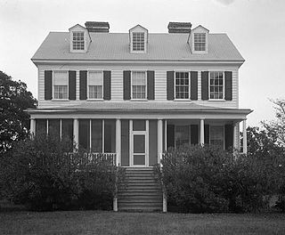
Oak Island, also known as the William Seabrook, Jr. House, is a historic plantation house located at Edisto Island, Charleston County, South Carolina. It was built about 1828–1831, and is a 2+1⁄2-story, five-bay, rectangular, central-hall, frame, weatherboard-clad residence with a projecting two-story rear pavilion. It features two, massive, interior chimneys with heavily corbelled caps and a one-story, wraparound hipped roof porch.

Rockville Historic District is a national historic district located at Rockville, Charleston County, South Carolina. The district encompasses 19 contributing buildings in the town of Rockville. The dwellings reflect Rockville's historic role as a summer resort town. The houses are characterized by spacious porches, raised foundations, and large central hallways designed for summer comfort and relaxation. Located in the district are the Grace Episcopal Church and Wadmalaw Presbyterian Church.


