Rockville, South Carolina

Last updated

Rockville, South Carolina
RockvilleSign.JPG
Sign entering Rockville
SCMap-doton-Rockville.PNG
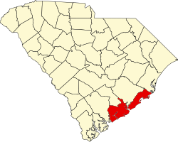
Location of Rockville
in South Carolina
Coordinates: 32°36′11″N80°11′49″W / 32.60306°N 80.19694°W / 32.60306; -80.19694
Country United States
State South Carolina
County Charleston
Government
   Mayor Riley Bradham
Area
[1]
  Total0.51 sq mi (1.33 km2)
  Land0.42 sq mi (1.10 km2)
  Water0.09 sq mi (0.23 km2)
Elevation
10 ft (3 m)
Population
 (2020) [2]
  Total141
  Density332.55/sq mi (128.50/km2)
Time zone UTC-5 (EST)
  Summer (DST) UTC-4 (EDT)
FIPS code 45-61495 [3]
GNIS feature ID1231739 [4]
Website townofrockville.com

Rockville is a town in Charleston County, South Carolina, United States, that was founded in 1784. The population was 134 at the 2010 census. [5] Rockville is part of the Charleston-North Charleston-Summerville metropolitan area.

Contents

History

The Hanckel Mound, Horse Island, Rockville Historic District, and John Seabrook Plantation Bridge are listed on the National Register of Historic Places. [6]

Geography

Rockville is located on Wadmalaw Island in southwestern Charleston County at 32°36′11″N80°11′49″W / 32.60306°N 80.19694°W / 32.60306; -80.19694 (32.602932, -80.196942), [7] at the south end of South Carolina Highway 700, on the north bank of tidal Bohicket Creek, an arm of the North Edisto River. To the south across Bohicket Creek is the town of Seabrook Island. SC Highway 700 leads northeast 11 miles (18 km) to Johns Island and 22 miles (35 km) to Charleston.

According to the United States Census Bureau, the town has a total area of 0.50 square miles (1.3 km2), of which 0.42 square miles (1.1 km2) is land and 0.1 square miles (0.2 km2), or 17.52%, is water. [5]

Demographics

Historical population
CensusPop.Note
2000 137
2010 134−2.2%
2020 1415.2%
U.S. Decennial Census [8] [2]

2020 census

Rockville racial composition [9]
RaceNum.Perc.
White (non-Hispanic)12588.65%
Black or African American (non-Hispanic)117.8%
Other/Mixed 21.42%
Hispanic or Latino 32.13%

As of the 2020 United States census, there were 141 people, 66 households, and 36 families residing in the town.

2000 census

As of the census [3] of 2000, there were 137 people, 64 households, and 44 families residing in the town. The population density was 314.7 inhabitants per square mile (121.5/km2). There were 84 housing units at an average density of 193.0 per square mile (74.5/km2). The racial makeup of the town was 86.86% White, 11.68% African American, 1.46% from other races. Hispanic or Latino of any race were 2.19% of the population.

There were 64 households, out of which 10.9% had children under the age of 18 living with them, 62.5% were married couples living together, 6.3% had a female householder with no husband present, and 29.7% were non-families. 28.1% of all households were made up of individuals, and 10.9% had someone living alone who was 65 years of age or older. The average household size was 2.14 and the average family size was 2.60.

In the town, the population was spread out, with 10.9% under the age of 18, 8.8% from 18 to 24, 16.1% from 25 to 44, 41.6% from 45 to 64, and 22.6% who were 65 years of age or older. The median age was 52 years. For every 100 females, there were 107.6 males. For every 100 females age 18 and over, there were 100.0 males.

The median income for a household in the town was $58,977, and the median income for a family was $69,821. Males had a median income of $45,208 versus $33,750 for females. The per capita income for the town was $36,620. There were 3.9% of families and 3.1% of the population living below the poverty line, including no under eighteens and none of those over 64.

Government

The city is run by an elected mayor–council government system.

Mayor

Riley A Bradham II

Council Members

Henry Holst, Mayor Pro Tem, Frank Thornhill, Judy Suggs, David Dunn

Related Research Articles

<span class="mw-page-title-main">Junction City, Georgia</span> Town in Georgia, United States

Junction City is a town in Talbot County, Georgia, United States. The population was 179 at the 2000 census.

<span class="mw-page-title-main">Rockville, Indiana</span> Town in Indiana, United States

Rockville is a town in Adams Township, Parke County, in the U.S. state of Indiana. The population was 2,607 at the 2010 census. The town is the county seat of Parke County. It is known as "The Covered Bridge Capital of the World".

<span class="mw-page-title-main">Rosedale, Indiana</span> Town in Indiana, United States

Rosedale is a town in Florida Township, Parke County, in the U.S. state of Indiana. The population was 725 at the 2010 census.

Rapid River Township is a township in Lake of the Woods County, Minnesota, United States. The population was 23 at the 2000 census.

<span class="mw-page-title-main">Rockville, Nebraska</span> Village in Sherman County, Nebraska, United States

Rockville is a village in Sherman County, Nebraska, United States. The population was 106 at the 2010 census.

<span class="mw-page-title-main">Seabrook, New Hampshire</span> Town in New Hampshire, United States

Seabrook is a town in Rockingham County, New Hampshire, United States. The population was 8,401 at the 2020 census. Located at the southern end of the coast of New Hampshire on the border with Massachusetts, Seabrook is noted as the location of the Seabrook Station Nuclear Power Plant, the third-most recently constructed nuclear power plant in the United States.

<span class="mw-page-title-main">South Hampton, New Hampshire</span> Town in New Hampshire, United States

South Hampton is a town in Rockingham County, New Hampshire, United States. The population was 894 at the 2020 census. South Hampton is home to Cowden State Forest and Powwow River State Forest.

<span class="mw-page-title-main">Seabrook Farms, New Jersey</span> Populated place in Cumberland County, New Jersey, US

Seabrook Farms is an unincorporated community and census-designated place (CDP) located within Seabrook, which is in turn located in Upper Deerfield Township, in Cumberland County, in the U.S. state of New Jersey. It is part of the Vineland-Bridgeton metropolitan statistical area for statistical purposes. At the 2010 census, Seabrook Farms's population was 1,484. Seabrook Farms is named after Charles F. Seabrook, a businessman who ran a truck farm that was one of the state's largest.

<span class="mw-page-title-main">Scott Township, Lawrence County, Pennsylvania</span> Township in Pennsylvania, United States

Scott Township is a township in Lawrence County, Pennsylvania, United States. The population was 2,174 at the 2020 census, a decline from the figure of 2,347 as of the 2010 census.

<span class="mw-page-title-main">Hollywood, South Carolina</span> Town in South Carolina, United States

Hollywood is a town in Charleston County, South Carolina, United States. The population was 4,714 at the 2010 census, up from 3,946 in 2000. Hollywood is part of the Charleston, South Carolina metropolitan area and the Charleston-North Charleston Urbanized Area.

<span class="mw-page-title-main">Meggett, South Carolina</span> Town in South Carolina, United States

Meggett is a town in Charleston County, South Carolina, United States. The population was 1,226 at the 2010 census. Meggett is part of the Charleston-North Charleston-Summerville metropolitan area.

<span class="mw-page-title-main">Ravenel, South Carolina</span> Town in South Carolina, United States

Ravenel is a town in Charleston County, South Carolina, United States. The population was 2,465 at the 2010 census. Ravenel is part of the Charleston-North Charleston-Summerville metropolitan area.

<span class="mw-page-title-main">Seabrook Island, South Carolina</span> Town in South Carolina, United States

Seabrook Island, formerly known as Simmons Island, is a barrier island in Charleston County, South Carolina, United States. The population was 1,714 at the 2010 census, up from 1,250 in 2000.

<span class="mw-page-title-main">Melvin, Texas</span> Town in Texas, United States

Melvin is a town in McCulloch County, Texas, United States. Its population was 179 at the 2010 census.

<span class="mw-page-title-main">Anmoore, West Virginia</span> Town in West Virginia, United States

Anmoore is a town in Harrison County, West Virginia, United States. It is located at the intersection of WV 58 and Interstate 79. The population was 514 at the 2020 census.

<span class="mw-page-title-main">Middlebourne, West Virginia</span> Town in West Virginia, United States

Middlebourne is a town in Tyler County, West Virginia, United States. The population was 715 at the 2020 census. It serves as the county seat of Tyler County.

<span class="mw-page-title-main">Ladson, South Carolina</span> Census-designated place in South Carolina, United States

Ladson is a census-designated place (CDP) in Berkeley, Charleston and Dorchester counties in the U.S. state of South Carolina. The population was 13,790 at the 2010 census. It is named in honor of the Ladson family, one of the oldest planter and merchant families in the Charleston area; one of its members was lieutenant governor James Ladson.

<span class="mw-page-title-main">De Soto, Wisconsin</span> Village in Wisconsin, United States

De Soto is a village mostly in Vernon County but also in Crawford County in Wisconsin. The population was 287 at the 2010 census. Of this, 179 were in living in Vernon County, and 108 were living in Crawford County. The downtown and business area is located in Crawford County.

The Town of Potosi is located in Grant County, Wisconsin, United States. The population was 831 at the 2000 census. The Village of Potosi and the unincorporated communities of British Hollow, Buena Vista, Rockville, and Van Buren are located in the town.

<span class="mw-page-title-main">Seabrook Beach, New Hampshire</span> Census-designated place in New Hampshire, United States

Seabrook Beach is a census-designated place in the town of Seabrook and partially in the town of Hampton in Rockingham County, New Hampshire, United States. It had a population of 1,078 at the 2020 census.

References

  1. "ArcGIS REST Services Directory". United States Census Bureau. Retrieved October 15, 2022.
  2. 1 2 "Census Population API". United States Census Bureau. Retrieved October 15, 2022.
  3. 1 2 "U.S. Census website". United States Census Bureau . Retrieved January 31, 2008.
  4. "US Board on Geographic Names". United States Geological Survey. October 25, 2007. Retrieved January 31, 2008.
  5. 1 2 "Geographic Identifiers: 2010 Census Summary File 1 (G001): Rockville town, South Carolina". U.S. Census Bureau, American Factfinder. Archived from the original on February 13, 2020. Retrieved June 29, 2015.
  6. "National Register Information System". National Register of Historic Places . National Park Service. July 9, 2010.
  7. "US Gazetteer files: 2010, 2000, and 1990". United States Census Bureau. February 12, 2011. Retrieved April 23, 2011.
  8. "Census of Population and Housing". Census.gov. Retrieved June 4, 2015.
  9. "Explore Census Data". data.census.gov. Retrieved December 15, 2021.