Hollywood, South Carolina | |
---|---|
Coordinates: 32°44′3″N80°14′30″W / 32.73417°N 80.24167°W | |
Country | United States |
State | South Carolina |
County | Charleston |
Government | |
• Mayor | Chardale Murray |
Area | |
• Total | 24.92 sq mi (64.54 km2) |
• Land | 23.57 sq mi (61.04 km2) |
• Water | 1.35 sq mi (3.49 km2) |
Elevation | 30 ft (9 m) |
Population | |
• Total | 5,339 |
• Density | 226.53/sq mi (87.46/km2) |
Time zone | UTC-5 (EST) |
• Summer (DST) | UTC-4 (EDT) |
ZIP code | 29449 |
Area code(s) | 843, 854 |
FIPS code | 45-34495 [3] |
GNIS feature ID | 1231398 [4] |
Website | www |
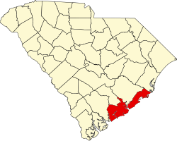
Hollywood is a town in Charleston County, South Carolina, United States. The population was 4,714 at the 2010 census, [5] up from 3,946 in 2000. Hollywood is part of the Charleston, South Carolina metropolitan area and the Charleston-North Charleston Urbanized Area.
Hollywood is located in western Charleston County at 32°44′48″N80°13′34″W / 32.7467°N 80.2260°W (32.7467, -80.2260). [6] It is bordered by Ravenel to the north and Meggett to the south. Charleston is 21 miles (34 km) to the east.
According to the United States Census Bureau, Hollywood has a total area of 24.5 square miles (63.5 km2), of which 23.1 square miles (59.9 km2) is land and 1.4 square miles (3.6 km2), or 5.64%, is water. [5]
Census | Pop. | Note | %± |
---|---|---|---|
1950 | 246 | — | |
1960 | 334 | 35.8% | |
1970 | 339 | 1.5% | |
1980 | 729 | 115.0% | |
1990 | 2,094 | 187.2% | |
2000 | 3,946 | 88.4% | |
2010 | 4,714 | 19.5% | |
2020 | 5,339 | 13.3% | |
U.S. Decennial Census [7] [2] |
Race | Num. | Perc. |
---|---|---|
White (non-Hispanic) | 2,482 | 46.49% |
Black or African American (non-Hispanic) | 2,399 | 44.93% |
Native American | 8 | 0.15% |
Asian | 27 | 0.51% |
Pacific Islander | 4 | 0.07% |
Other/Mixed | 139 | 2.6% |
Hispanic or Latino | 280 | 5.24% |
As of the 2020 United States census, there were 5,339 people, 2,070 households, and 1,405 families residing in the town.
As of the census [3] of 2000, there were 3,946 people, 1,392 households, and 1,056 families residing in the town. The population density was 196.8 inhabitants per square mile (76.0/km2). There were 1,516 housing units at an average density of 75.6 per square mile (29.2/km2). The racial makeup of the town was 68.78% African American, 29.78% White, 0.15% Native American, 0.10% Asian, 0.03% Pacific Islander, 0.79% from other races, and 0.38% from two or more races. Hispanic or Latino of any race were 1.72% of the population.
There were 1,392 households, out of which 32.0% had children under the age of 18 living with them, 48.2% were married couples living together, 23.0% had a female householder with no husband present, and 24.1% were non-families. 20.7% of all households were made up of individuals, and 8.1% had someone living alone who was 65 years of age or older. The average household size was 2.83 and the average family size was 3.30.
In the town, the population was spread out, with 29.5% under the age of 18, 7.6% from 18 to 24, 26.3% from 25 to 44, 26.3% from 45 to 64, and 10.3% who were 65 years of age or older. The median age was 37 years. For every 100 females, there were 86.4 males. For every 100 females age 18 and over, there were 83.9 males.
The median income for a household in the town was $30,297, and the median income for a family was $35,406. Males had a median income of $29,306 versus $20,115 for females. The per capita income for the town was $17,521. About 18.7% of families and 22.4% of the population were below the poverty line, including 31.3% of those under age 18 and 32.0% of those age 65 or over.
The city is run by an elected mayor-council government system.
Annette Sausser, Handy Miles Jr., Althea Salters, Michelle Heyward Dunmeyer, and Herbert Townsend.
Former: Kenneth L. Smalls Sr. [9]
Marydel is an incorporated town in Caroline County, Maryland, United States. The population was 141 at the 2010 United States Census. Its name is a portmanteau, after its location, being partially located in Maryland and partially in Delaware. Marydel was originally known as Halltown.
Allendale is a town in and the county seat of Allendale County, South Carolina, United States. The population was 3,482 at the 2010 census, a decline from 4,052 in 2000.
Bonneau is a town in Berkeley County, South Carolina, United States. The population was 487 at the 2010 census. It is part of the Charleston–North Charleston–Summerville Metropolitan Statistical Area.
Moncks Corner is a town in and the county seat of Berkeley County, South Carolina, United States. The population was 7,885 at the 2010 census. As defined by the U.S. Census Bureau, Moncks Corner is included within the Charleston-North Charleston, SC Metropolitan Statistical Area.
St. Stephen is a town in Berkeley County, South Carolina, United States. The population was 1,697 at the 2010 census.
Awendaw is a small fishing town in Charleston County, South Carolina, United States. The population was 1,294 at the 2010 census. Awendaw is part of the Charleston, South Carolina metropolitan area.
Lincolnville is a town in Charleston County, South Carolina, United States. A very small portion of the town extends into Dorchester County. The population was 1,139 at the 2010 census, up from 904 in 2000.
Meggett is a town in Charleston County, South Carolina, United States. The population was 1,226 at the 2010 census. Meggett is part of the Charleston-North Charleston-Summerville metropolitan area.
Ravenel is a town in Charleston County, South Carolina, United States. The population was 2,465 at the 2010 census. Ravenel is part of the Charleston-North Charleston-Summerville metropolitan area.
Rockville is a town in Charleston County, South Carolina, United States, that was founded in 1784. The population was 134 at the 2010 census. Rockville is part of the Charleston-North Charleston-Summerville metropolitan area.
Seabrook Island, formerly known as Simmons Island, is a barrier island in Charleston County, South Carolina, United States. The population was 1,714 at the 2010 census, up from 1,250 in 2000.
Edisto Beach is a town in Colleton County, South Carolina, United States. Edisto Beach's population was 414 as of the 2010 census, down from 641 in 2000. The town limits include only the developed coastal area of Edisto Island within Colleton County, while the majority of the island consists of unincorporated land in Charleston County. Due to its status as a bedroom community, Edisto Beach is among the most affluent communities in the state.
Harleyville is a town in Dorchester County, South Carolina, United States. The population was 677 at the 2010 census, up from 594 at the 2000 census. Harleyville is part of the Charleston-North Charleston-Summerville metropolitan area. As of 2018 the population is 696.
Reevesville is a town in Dorchester County, South Carolina, United States. The population was 196 at the 2010 census. As defined by the U.S. Office of Management and Budget, and used by the U.S. Census Bureau for statistical purposes only, Reevesville is included within the Charleston-North Charleston-Summerville metropolitan area.
Ridgeville is a town in Dorchester County, South Carolina, United States. The population was 1,979 at the 2010 census, up from 1,690 at the 2000 census. Ridgeville is part of the Charleston-North Charleston-Summerville metropolitan area.
Saint George is a town in Dorchester County, South Carolina, United States. The population was 2,084 at the 2010 census, eight fewer than in 2000 census. It has been the county seat of Dorchester County since the county was formed from Colleton County in 1897.
Furman is a town in Hampton County, South Carolina, United States. The population was 224 at the 2020 census, down from 239 at the 2010 census. It is not to be confused with Furman University, which is in Greenville, South Carolina.
Anmoore is a town in Harrison County, West Virginia, United States. It is located at the intersection of WV 58 and Interstate 79. The population was 514 at the 2020 census.
Ladson is a census-designated place (CDP) in Berkeley, Charleston and Dorchester counties in the U.S. state of South Carolina. The population was 13,790 at the 2010 census. It is named in honor of the Ladson family, one of the oldest planter and merchant families in the Charleston area; one of its members was lieutenant governor James Ladson.
Andrews is a town in both Georgetown and Williamsburg counties in the U.S. state of South Carolina. Its total population was 2,861 at the 2010 census, down from 3,068 in 2000. General aviation airfield Robert F. Swinnie Airport is 2 miles (3 km) east of its central business district.