Ravenel, South Carolina

Last updated

Ravenel, South Carolina
Ravenel-Depot-sc.jpg
Ravenel Depot
SCMap-doton-Ravenel.PNG
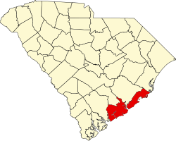
Location of Ravenel in South Carolina
Coordinates: 32°45′52″N80°14′24″W / 32.76444°N 80.24000°W / 32.76444; -80.24000
Country United States
State South Carolina
County Charleston
Government
   Mayor Stephen W. Tumbleston
Area
[1]
  Total13.18 sq mi (34.13 km2)
  Land13.18 sq mi (34.13 km2)
  Water0.00 sq mi (0.01 km2)
Elevation
38 ft (12 m)
Population
 (2020) [2]
  Total2,542
  Density192.93/sq mi (74.49/km2)
Time zone UTC-5 (EST)
  Summer (DST) UTC-4 (EDT)
ZIP code
29470
Area code(s) 843, 854
FIPS code 45-59020 [3]
GNIS feature ID1225766 [4]
Website www.townofravenel.com

Ravenel is a town in Charleston County, South Carolina, United States. The population was 2,465 at the 2010 census. [5] Ravenel is part of the Charleston-North Charleston-Summerville metropolitan area.

Contents

Geography

Ravenel is located in western Charleston County at 32°46′41″N80°13′16″W / 32.77806°N 80.22111°W / 32.77806; -80.22111 (32.777930, -80.221112). [6] It is bordered to the south by the town of Hollywood. U.S. Route 17 passes through the town, leading 20 miles (32 km) east to Charleston and 13 miles (21 km) west to Jacksonboro.

According to the United States Census Bureau, Ravenel has a total area of 12.6 square miles (32.7 km2), all land. [5]

Demographics

Historical population
CensusPop.Note
1950 337
1960 52756.4%
1970 93176.7%
1980 1,65577.8%
1990 2,16530.8%
2000 2,2142.3%
2010 2,46511.3%
2020 2,5423.1%
U.S. Decennial Census [7] [2]

2020 census

Ravenel racial composition [8]
RaceNum.Perc.
White (non-Hispanic)1,19947.17%
Black or African American (non-Hispanic)89135.05%
Native American 100.39%
Asian 40.16%
Other/Mixed 622.44%
Hispanic or Latino 37614.79%

As of the 2020 United States census, there were 2,542 people, 986 households, and 662 families residing in the town.

2000 census

As of the census [3] of 2000, there were 2,214 people, 799 households, and 581 families residing in the town. The population density was 179.5 inhabitants per square mile (69.3/km2). There were 863 housing units at an average density of 70.0 per square mile (27.0/km2). The racial makeup of the town was 47.88% White, 49.95% African American, 0.05% Native American, 0.41% Asian, 1.13% from other races, and 0.59% from two or more races. Hispanic or Latino of any race were 2.66% of the population.

There were 799 households, out of which 36.2% had children under the age of 18 living with them, 49.3% were married couples living together, 19.1% had a female householder with no husband present, and 27.2% were non-families. 21.0% of all households were made up of individuals, and 7.3% had someone living alone who was 65 years of age or older. The average household size was 2.76 and the average family size was 3.25.

In the town, the population was spread out, with 30.4% under the age of 18, 7.4% from 18 to 24, 28.5% from 25 to 44, 24.4% from 45 to 64, and 9.3% who were 65 years of age or older. The median age was 35 years. For every 100 females, there were 92.4 males. For every 100 females age 18 and over, there were 87.7 males.

The median income for a household in the town was $33,021, and the median income for a family was $36,477. Males had a median income of $33,009 versus $21,306 for females. The per capita income for the town was $15,495. About 15.9% of families and 18.3% of the population were below the poverty line, including 25.8% of those under age 18 and 11.9% of those age 65 or over.

Government

The city is run by an elected mayor–council government system.

Mayor

Stephen W. Tumbleston

Council members

Robert L. Cochran, Terry Wilkinson, A. Gail Farrior, Jr., James R. Rodgers Jr., Harold T. "Buck" Dukes, Jr., Buckey Waters

Related Research Articles

<span class="mw-page-title-main">North Courtland, Alabama</span> Town in Alabama, United States

North Courtland is a town in Lawrence County, Alabama, United States, and is included in the Decatur Metropolitan Area, as well as the Huntsville-Decatur Combined Statistical Area. It incorporated in 1981. At the 2010 census, the population of the town was 632, down from 799 in 2000. Along with Hillsboro, it is one of two majority black communities in Lawrence County out of its six populated communities as of 2010.

<span class="mw-page-title-main">Tenakee Springs, Alaska</span> City in Alaska, United States

Tenakee Springs is a city on Chichagof Island in Hoonah-Angoon Census Area, Alaska, United States. At the 2010 census the population was 131, up from 104 at the 2000 census.

<span class="mw-page-title-main">Raymond, Iowa</span> City in Iowa, United States

Raymond is a city in Black Hawk County, Iowa, United States. The population was 759 at the time of the 2020 census. It is part of the Waterloo–Cedar Falls Metropolitan Statistical Area.

<span class="mw-page-title-main">North Pembroke, Massachusetts</span> Census-designated place in Massachusetts, United States

North Pembroke is a census-designated place (CDP) in the town of Pembroke in Plymouth County, Massachusetts, United States. The population was 3,292 at the 2010 census.

<span class="mw-page-title-main">St. Stephen, South Carolina</span> Town in South Carolina, United States

St. Stephen is a town in Berkeley County, South Carolina, United States. The population was 1,697 at the 2010 census.

<span class="mw-page-title-main">Hollywood, South Carolina</span> Town in South Carolina, United States

Hollywood is a town in Charleston County, South Carolina, United States. The population was 4,714 at the 2010 census, up from 3,946 in 2000. Hollywood is part of the Charleston, South Carolina metropolitan area and the Charleston-North Charleston Urbanized Area.

<span class="mw-page-title-main">Meggett, South Carolina</span> Town in South Carolina, United States

Meggett is a town in Charleston County, South Carolina, United States. The population was 1,226 at the 2010 census. Meggett is part of the Charleston-North Charleston-Summerville metropolitan area.

<span class="mw-page-title-main">Rockville, South Carolina</span> Town in South Carolina, United States

Rockville is a town in Charleston County, South Carolina, United States, that was founded in 1784. The population was 134 at the 2010 census. Rockville is part of the Charleston-North Charleston-Summerville metropolitan area.

<span class="mw-page-title-main">Seabrook Island, South Carolina</span> Town in South Carolina, United States

Seabrook Island, formerly known as Simmons Island, is a barrier island in Charleston County, South Carolina, United States. The population was 1,714 at the 2010 census, up from 1,250 in 2000.

<span class="mw-page-title-main">Great Falls, South Carolina</span> Town in South Carolina, United States

Great Falls is a town in Chester County, South Carolina, United States and is located fourteen miles southwest of Lancaster, South Carolina. The population was 1,951 at the 2020 census.

<span class="mw-page-title-main">Chesterfield, South Carolina</span> Town in South Carolina, United States

Chesterfield is a town in Chesterfield County, South Carolina, United States. The population was 1,472 at the 2010 census. It is the county seat of Chesterfield County. At the time of the 2010 census, Chesterfield was the least populous of all of South Carolina's county seats.

<span class="mw-page-title-main">Mount Croghan, South Carolina</span> Town in South Carolina, United States

Mount Croghan is a town in Chesterfield County, South Carolina, United States. The population was 195 at the 2010 census, up from 155 in 2000. It houses a Flea market

<span class="mw-page-title-main">Anmoore, West Virginia</span> Town in West Virginia, United States

Anmoore is a town in Harrison County, West Virginia, United States. It is located at the intersection of WV 58 and Interstate 79. The population was 514 at the 2020 census.

<span class="mw-page-title-main">Chesapeake, West Virginia</span> Town in West Virginia, United States

Chesapeake is a town in Kanawha County, West Virginia, United States. The population was 1,336 at the 2020 census. The town is situated on the Kanawha River.

<span class="mw-page-title-main">White Hall, West Virginia</span> Town in West Virginia, United States

White Hall is a town in Marion County, West Virginia, United States. The population was 706 at the 2020 census. Incorporated in 1989, White Hall is adjacent to the county seat, Fairmont, and is part of the Fairmont, West Virginia, Micropolitan Statistical Area. White Hall has many different stores and restaurants.

<span class="mw-page-title-main">Worthington, West Virginia</span> Town in West Virginia, United States

Worthington is a town in Marion County, West Virginia, United States. The population was 158 at the 2010 census. Worthington was incorporated in 1893 and named for Colonel George Worthington, an early settler. U.S. Route 19 passes through the town.

<span class="mw-page-title-main">Middlebourne, West Virginia</span> Town in West Virginia, United States

Middlebourne is a town and the county seat of Tyler County, West Virginia, United States. The population was 715 at the 2020 census.

<span class="mw-page-title-main">Ladson, South Carolina</span> Census-designated place in South Carolina, United States

Ladson is a census-designated place (CDP) in Berkeley, Charleston and Dorchester counties in the U.S. state of South Carolina. The population was 13,790 at the 2010 census. It is named in honor of the Ladson family, one of the oldest planter and merchant families in the Charleston area; one of its members was lieutenant governor James Ladson.

<span class="mw-page-title-main">Niagara, Wisconsin</span> City in Wisconsin, United States

Niagara is a city in Marinette County, Wisconsin, United States. The population was 1,602 at the 2020 census. The city lies to the north of and adjacent to the Town of Niagara. It is part of the Marinette, WI–MI Micropolitan Statistical Area.

<span class="mw-page-title-main">Farmingdale (CDP), Maine</span> Census-designated place in Maine, United States

Farmingdale is a census-designated place (CDP) in the town of Farmingdale in Kennebec County, Maine, United States. The population was 1,970 at the 2010 census, out of 2,956 in the entire town.

References

  1. "ArcGIS REST Services Directory". United States Census Bureau. Retrieved October 15, 2022.
  2. 1 2 "Census Population API". United States Census Bureau. Retrieved October 15, 2022.
  3. 1 2 "U.S. Census website". United States Census Bureau . Retrieved January 31, 2008.
  4. "US Board on Geographic Names". United States Geological Survey. October 25, 2007. Retrieved January 31, 2008.
  5. 1 2 "Geographic Identifiers: 2010 Census Summary File 1 (G001): Ravenel town, South Carolina". U.S. Census Bureau, American Factfinder. Archived from the original on February 13, 2020. Retrieved June 29, 2015.
  6. "US Gazetteer files: 2010, 2000, and 1990". United States Census Bureau. February 12, 2011. Retrieved April 23, 2011.
  7. "Census of Population and Housing". Census.gov. Retrieved June 4, 2015.
  8. "Explore Census Data". data.census.gov. Retrieved December 15, 2021.