
Rockville is a town in Charleston County, South Carolina, United States, that was founded in 1784. The population was 134 at the 2010 census. Rockville is part of the Charleston-North Charleston-Summerville metropolitan area.

This is a list of the National Register of Historic Places listings in Charleston County, South Carolina.

Marshlands Plantation House, in Charleston, South Carolina, is an historic plantation house that was built in 1810 and listed in the National Register of Historic Places on March 30, 1973. It is a 2 1⁄2-story Federal-style plantation home. The house was relocated in the 1960s from its original location on the site of the United States Navy Shipyard. The Navy had announced it would have to demolish the empty house if it could not be relocated with the $15,000 the Navy had set aside for the purpose. The City of Charleston took temporary possession of the house, transferring it to the College of Charleston which relocated it for preservation to James Island.

Charleston Navy Yard Officers' Quarters Historic District is a national historic district located at the former Charleston Naval Shipyard in North Charleston, South Carolina. It encompasses 24 contributing buildings, 2 contributing sites, 1 contributing structure, and 1 contributing object. The site represents development of the upper echelon of senior military housing, support structures, sports facilities and recreational landscape features from 1901 through 1945. The buildings reflect late Victorian and early-20th century eclectic designs including the Italianate, Neo-Classical, Italian Renaissance Revival, Colonial Revival, and the Works Progress Administration (WPA) designed Panama House style.
Hanckel Mound (38CH7) is a historic mound located near Rockville, Charleston County, South Carolina. It is one of 20 or more prehistoric shell rings located from the central coast of South Carolina to the central coast of Georgia. On average, it measures 158 feet in diameter and stands 8 feet high. The midden is largely composed of oyster shell.
Horse Island (38CH14) is a historic mound located near Rockville, Charleston County, South Carolina. It is one of 20 or more prehistoric shell rings located from the central coast of South Carolina to the central coast of Georgia. On average, it measures 156 feet in diameter and stands 4 feet high. The midden is largely composed of oyster shell.
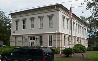
Old Berkeley County Courthouse, also known as Old Courthouse, is a historic courthouse located at Mount Pleasant, Charleston County, South Carolina. It was built in 1884, and is a two-story, rectangular, stucco over brick building in the Italianate style. It features large matching double stairways leading to the main entrance on the second floor. The building served as county courthouse for Berkeley County from 1884 to 1898. After 1898 until 1968, it was used by both Baptists and Lutherans as a church. It is now known as the G. Mcgrath Darby Building.

Fort Palmetto is a historic artillery battery located at Christ Church Parish, Hamlin Sound, Charleston County, South Carolina. It was built in late 1861, and was at the easternmost end of the Christ Church Parish line of defense. At the end of the war this battery mounted one nine-inch gun and two rifled thirty-two pounders. The earthen redoubt measures approximately 160 feet long and 80 feet wide. It has a 15 foot high parapet wall and a powder magazine about 25 feet in height.

Willtown Bluff, also known as Wilton and New London, is a historic settlement site located on the S. Edisto River near Adams Run, Charleston County, South Carolina. Founded about 1704, it was the second planned town to be established after the relocation of Charleston in 1682. Willtown served as a local governmental center and regional commercial center. The property includes three early-19th century buildings: the Parsonage, the Willtown Plantation House, and the remains of a single column of the Episcopal church. Unexposed remains are of a colonial village thought to have had 80 houses.
Hephzibah Jenkins Townsend's Tabby Oven Ruins is a historic archaeological site located at Edisto Island, Charleston County, South Carolina. The remains represent what was essentially a commercial bakery.
John Seabrook Plantation Bridge, also known as Admiral George Palmer's Bridge, is a historic arch bridge located at Rockville, Charleston County, South Carolina. It was built about 1782, and is constructed of brick veneer enclosing a fill mixture of crushed oyster shells and rammed earth.

Mount Pleasant Historic District is a national historic district located at Mount Pleasant, Charleston County, South Carolina. The district encompasses nine contributing buildings in the town of Mount Pleasant. The dwellings reflect Mount Pleasant's historic role as a summer resort town. The building reflect architectural styles of the 18th, 19th and early 20th centuries, including vernacular Georgian, Greek Revival and Gothic Revival. Notable buildings include the Mount Pleasant Presbyterian Church, St. Andrews Episcopal Church, Mount Pleasant Seventh-Day Adventist Church, Hibben-McIver House, 200 Bank Street, and the Captain Peter Lewis House. Located in the district is the separately listed Old Courthouse.
McClellanville Historic District is a national historic district located at McClellanville, Charleston County, South Carolina. The district encompasses 105 contributing buildings in the town of McClellanville. They include residential, commercial, religious and educational building dating between about 1860 to 1935. Architectural styles include: Carpenter Gothic, Queen Anne, and Italianate. Notable buildings include the King Brothers Store, McClellanville Public School, New Wappetaw Presbyterian Church, Bank of McClellanville, McClellanville Methodist Episcopal Church, and a number of dwellings originally built as summer homes by St. James Santee and Georgetown planters.
Atlanticville Historic District is a national historic district located at Sullivan's Island, Charleston County, South Carolina. The district encompasses 45 contributing buildings, 1 contributing site, and 1 contributing structure in Atlanticville. They predominantly include frame residences built between about 1880 to 1950 which are known as “island houses.” Also located in the district are the Chapel of the Holy Cross and the Sullivan's Island Graded School.

Moultrieville Historic District is a national historic district located at Sullivan's Island, Charleston County, South Carolina. The district encompasses 18 contributing buildings and 1 contributing site in Moultrieville. They predominantly include frame residences built between about 1830 to 1930 which are known as "Island Houses." Also located in the district are the Stella Maris Catholic Church (1869-1873) and Fort Moultrie Torpedo Shed/Mines Storehouse.

Sullivan's Island Historic District is a national historic district located at Sullivan's Island, Charleston County, South Carolina. The district encompasses 36 contributing buildings on Sullivan's Island. They predominantly include the core residential and administrative areas of Fort Moultrie built between about 1870 to 1950. Also included are representative "Island Houses" and the Post Chapel. Notable buildings include the Base Commander's Quarters, nine Senior Officers' Quarters, ten Junior Officers' Quarters, the Bachelor Officers' Quarters, the Administration Building, the Post Exchange and Gymnasium, and the Electrical Shop.

U.S. Coast Guard Historic District is a national historic district located at Sullivan's Island, Charleston County, South Carolina. The district encompasses three contributing buildings and one contributing structure on Sullivan's Island. The property was established as a life saving station in 1891. The district contains the station house/administration building, boathouse, garage, and signal tower, which are laid out in an "L"-shaped court loosely organized around the bunker/sighting station. Also on the property is the non-contributing Charleston Light.

Secessionville Historic District is a national historic district located near Folly Beach, Charleston County, South Carolina. It extends into the city of Charleston, South Carolina. The district encompasses six contributing buildings, one contributing site, and one contributing site in Secessionville. The district includes the summer homes of several leading James Island planters, the site of the American Civil War Battle of Secessionville, the unmarked grave of over 300 Union soldiers, and the remains of Fort Lamar, constructed about 1862.


