Jolly Harbour

Last updated
Aerial view of Jolly Harbour. Jolly Harbour.jpg
Aerial view of Jolly Harbour.
Beach at Jolly Harbour. Jolly Bay Antigua.JPG
Beach at Jolly Harbour.

Jolly Harbour is a township on Antigua island, in Antigua and Barbuda.

Contents

Geography

The town is located on the southwest coast of the island in Saint Mary Parish, close to Bolands and south of Five Island Harbour. [1] Jolly Harbour is a district of the Bolands community.

Tourism

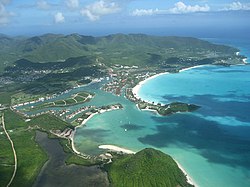
The marina and commercial activity are a major draw for tourists, with Jolly Harbour having shops, bars, restaurants, a golf-course and a boatyard. The marina complex was developed on land that was previously a swamp and beach. The marina is dominated by the casino building, which has laid abandoned for many years. The area is a popular location for expats to buy property as there is also a gated community.

Demographics

Jolly Harbour has three enumeration districts.

Census data (2011) [2]

Individual

Q48 EthnicCounts%
African descendent63974.69%
Caucasian/White15217.78%
East Indian/India131.48%
Mixed (Black/White)70.86%
Mixed (Other)232.72%
Hispanic50.62%
Syrian/Lebanese30.37%
Other70.86%
Don't know/Not stated50.62%
Total855100.00%
Q49 ReligionCounts%
Adventist11112.98%
Anglican17320.27%
Baptist101.11%
Church of God121.36%
Evangelical202.35%
Jehovah Witness40.49%
Methodist627.29%
Moravian566.55%
Nazarene566.55%
None/no religion687.91%
Pentecostal8710.14%
Rastafarian40.49%
Roman Catholic9010.51%
Wesleyan Holiness182.10%
Other343.96%
Don't know/Not stated515.93%
Total854100.00%
NotApp :1
Q58. Country of birthCounts%
Africa101.11%
Other Latin or North American countries10.12%
Antigua and Barbuda52861.73%
Other Caribbean countries50.62%
Canada202.35%
Other Asian countries111.23%
Other European countries414.81%
Dominica192.22%
Dominican Republic70.86%
Guyana364.20%
Jamaica586.79%
Monsterrat80.99%
St. Kitts and Nevis20.25%
St. Lucia60.74%
St. Vincent and the Grenadines20.25%
Trinidad and Tobago30.37%
United Kingdom536.17%
USA354.07%
USVI United States Virgin Islands10.12%
Not Stated80.99%
Total855100.00%
Q71 Country of Citizenship 1Counts%
Antigua and Barbuda62472.96%
Other Caribbean countries10.12%
Canada263.09%
Other Asian and Middle Eastern countries60.74%
Dominica70.86%
Dominican Republic50.62%
Guyana242.84%
Jamaica435.06%
Monsterrat60.74%
St. Lucia30.37%
St. Vincent and the Grenadines40.49%
Trinidad and Tobago10.12%
United Kingdom424.94%
USA202.35%
Other countries343.95%
Not Stated60.74%
Total855100.00%
Q71 Country of Citizenship 2 (Country of Second Citizenship)Counts%
Other Caribbean countries86.06%
Canada86.06%
Dominica149.85%
Dominican Republic32.27%
Guyana86.06%
Jamaica1611.36%
Monsterrat32.27%
St. Lucia43.03%
Trinidad and Tobago21.52%
United Kingdom2014.39%
USA2719.70%
Other countries2417.42%
Total139100.00%
NotApp :716
Q55 Internet UseCounts%
Yes48456.54%
No36142.22%
Don't know/Not stated111.23%
Total855100.00%
Employment statusCounts%
Employed38959.84%
Unemployed396.02%
Inactive22133.98%
Not stated10.16%
Total649100.00%
NotApp :206

Household

There are 295 households in Jolly Harbour.

Q4 Year builtCounts%
Before 198051.69%
1980–19894214.24%
1990–19996522.03%
2000–20065117.29%
Year 2007113.73%
Year 200851.69%
Year 200931.02%
Year 201062.03%
Don't Know/not stated10736.27%
Total295100.00%
Q11 Garbage disposalCounts%
Garbage truck Private7926.78%
Garbage truck Public21372.20%
Other (inc. burning, burying, compost, dumping)20.68%
Don't know/Not stated10.34%
Total295100.00%
Q23 3a Desktop ComputerCounts%
Yes7726.10%
No21873.90%
Total295100.00%
Q23 1 Air conditionerCounts%
Yes10033.90%
No19566.10%
Total295100.00%
Q23 3b Laptop ComputerCounts%
Yes15050.85%
No14549.15%
Total295100.00%
Q23 9 Mobile DeviceCounts%
Yes27292.20%
No237.80%
Total295100.00%
Q23 10 RadioCounts%
Yes17157.97%
No12442.03%
Total295100.00%
Q25 4 Household internet accessCounts%
No12141.02%
Yes14549.15%
Don't know/not declared299.83%
Total295100.00%
Q24 Motor VehiclesCounts%
08028.67%
113548.39%
25118.28%
382.87%
4 or more51.79%
Total279100.00%
Missing :16

Related Research Articles

<span class="mw-page-title-main">Saint Mary, Antigua and Barbuda</span> Parish in Antigua and Barbuda

Saint Mary, officially the Parish of Saint Mary, is a parish of Antigua and Barbuda on the island of Antigua. Saint Mary borders Saint John to the north, and Saint Paul to the east. Saint Mary is dominated by the Shekerley Mountains, and its northern border is largely defined by the mountains, and by Cooks Creek. The largest city in the parish is Bolans, home to the Jolly Harbour neighbourhood, and the parish church is located in Old Road. Saint Mary was created with the other five original parishes on 11 January 1692. It had a population of 7,341 in 2011, and 8,141 in 2018.

<span class="mw-page-title-main">Saint Paul, Antigua and Barbuda</span> Parish in Antigua and Barbuda

Saint Paul, officially the Parish of Saint Paul, is a parish of Antigua and Barbuda on the island of Antigua. Saint Paul borders Saint Peter and Saint John to the north, Saint Mary to the west, and Saint Philip to the east. Saint Paul is dominated by farmland in the north, with various creeks and Potworks Dam marking its northern border, and low-lying hills to the south, defining its western border with Saint Mary. The largest city fully within the parish is Liberta, the fourth largest city in the country. The parish capital, and the location of the parish church, is Falmouth. The main economic and tourism hub of the parish is English Harbour. Saint Paul was created with the other five original parishes on 11 January 1692. It had a population of 9,004 in 2018.

<span class="mw-page-title-main">Saint Peter, Antigua and Barbuda</span> Parish in Antigua and Barbuda

Saint Peter, officially the Parish of Saint Peter, is a parish of Antigua and Barbuda on the island of Antigua. Saint Peter borders Saint Paul to the south, Saint Philip to the east, and Saint George and Saint John to the west. Saint Peter is dominated by farmland, savanna, and undeveloped fields, and its borders are not well-defined. The largest city fully within the parish is Parham, which is also the capital. However, the portion of the city of All Saints in Saint Peter is significantly larger than Parham. Saint Peter was created with the other five original parishes on 11 January 1692. It had a population of 5,325 in 2011.

<span class="mw-page-title-main">Bolans</span> Village in Antigua, Antigua and Barbuda

Bolans is a community on the south-western end of the island of Antigua, headtown of the Saint Mary's Parish. It was once an agrarian community but has slowly been transformed into a centre of tourist activity. There are those in the community who involve themselves in agricultural activity, more as an avenue of feeding themselves or adding some needed income. Bolans is home to the world-famous Jolly Beach Resort as well as Jolly Harbour Marina and Boatyard which provides a sheltered dockage with 24-hour security and a full-service boatyard. It had a population of 1,888 in 2001.

<span class="mw-page-title-main">All Saints, Antigua and Barbuda</span> Village in Antigua, Antigua and Barbuda

All Saints is the second largest town in Antigua and Barbuda, with a population of 3,412. It is located in the middle of Antigua, at 17°3′N61°47′W. Just 5 miles NW of here is the capital, St. John's. It had a population of 3,900 in 2001.

Seatons is a village in Saint Philip Parish, located on eastern Antigua island in Antigua and Barbuda.

<span class="mw-page-title-main">Geography of Antigua and Barbuda</span>

Antigua and Barbuda lie in the eastern arc of the Leeward Islands of the Lesser Antilles, separating the Atlantic Ocean from the Caribbean Sea. Antigua is 650 km (400 mi) southeast of Puerto Rico; Barbuda lies 48 km (30 mi) due north of Antigua, and the uninhabited island of Redonda is 56 km (35 mi) southwest of Antigua.

<span class="mw-page-title-main">Five Islands, Antigua and Barbuda</span> Village in Antigua, Antigua and Barbuda

Five Islands Village is a village located on the northwest coast of Antigua, within Saint John Parish in Antigua and Barbuda.

Cedar Valley is a settlement in Saint John Parish, Antigua and Barbuda.

<span class="mw-page-title-main">Barbuda-South</span> Village and Enumeration District in Barbuda

Barbuda-South or Barbuda South River Road, is a village and enumeration district on the island of Barbuda.

Collins is a village in Saint Philip Parish, Antigua and Barbuda.

Vernons is a town in Saint Peter Parish, Antigua and Barbuda.

Upper Gamble's is a village in Saint John Parish, Antigua and Barbuda.

Carlisle is a village in Saint George Parish, Antigua and Barbuda.

Clare Hall is a village in Saint John Parish, Antigua and Barbuda.

<span class="mw-page-title-main">Cobbs Cross</span> Village in Antigua, Antigua and Barbuda

Cobbs Cross is a village in Saint Paul Parish, Antigua and Barbuda.

Pattersons is a village in Saint Paul Parish, Antigua and Barbuda.

<span class="mw-page-title-main">St. Mary's South</span> Parliamentary constituency in the parish of Saint Mary, Antigua and Barbuda

St. Mary's South is a parliamentary constituency in the parish of Saint Mary, Antigua and Barbuda. A by-election was held in the constituency on 24 October 2023.

References

  1. "Word Gazetteer" . Retrieved 5 January 2011.
  2. "Antigua and Barbuda::Statistics Division/Redatam Webserver | Statistical Process and Dissemination Tool". redatam.org. Retrieved 2021-12-28.

17°03′58″N61°53′14″W / 17.06611°N 61.88722°W / 17.06611; -61.88722