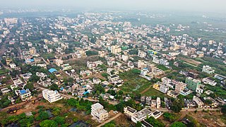
Tangellamudi is a census town in Eluru district of the Indian state of Andhra Pradesh. It is in Eluru mandal of Eluru revenue division. The town is a constituent of Eluru urban agglomeration. The nearest railway station is in Powerpet and is 1.5 km.

Gavaravaram is a census town in Eluru district of the Indian state of Andhra Pradesh. Gavaravaram is also known as Venkayapalam because of Gopina venkana garu 1914 to 1991 who is great person and owned most areas of the village once up on a time. It is located in Eluru mandal of Eluru revenue division. The town is a constituent of Eluru urban agglomeration.

Satrampadu is a census town in Eluru district of the Indian state of Andhra Pradesh. It is located in Eluru mandal of Eluru revenue division. The town is a constituent of Eluru urban agglomeration.

Sanivarapupeta is a census town in Eluru district of the Indian state of Andhra Pradesh. It is located in Eluru mandal of Eluru revenue division. The town is a constituent of Eluru urban agglomeration.
Mundur is a village in Eluru district of the Indian state of Andhra Pradesh. It is located in Pedavegi mandal of Eluru revenue division.
Vijayarai is a village in Eluru district of the Indian state of Andhra Pradesh. It is located in Pedavegi mandal of Eluru revenue division. It is located at a distance of 15 km from district headquarters Eluru city.
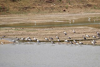
Guntupalle is a village in Eluru District of the Indian state of Andhra Pradesh. It is located in Kamavarapukota mandal of Eluru revenue division. It is located at a distance of 42 km from district headquarters Eluru city. It is well known tourist destination famously known for Guntupalli caves. The nearest train station is Eluru railway station.
Tadikalapudi is a village in Eluru district of the Indian state of Andhra Pradesh. It is located in Kamavarapukota mandal of Eluru revenue division. It is located at a distance of 26 km from district headquarters Eluru city.
Vanguru is a village in Eluru district of the Indian state of Andhra Pradesh. It is located in Pedavegi mandal of Eluru revenue division. It is located at a distance of 4 km from district headquarters Eluru city.
Kalaparru is a village in Eluru district of the Indian state of Andhra Pradesh. It is located in Pedapadu mandal of Eluru revenue division. It is located at a distance of 13 km from district headquarters Eluru city. The nearest train station is Vatlur railway station located at a distance of 3.89 Km.
Dondapadu is a village in Eluru district of the Indian state of Andhra Pradesh. It is located in Pedavegi mandal of Eluru revenue division. It is located at a distance of 5 km from district headquarters Eluru city.
Jalipudi is a village in Eluru district of the Indian state of Andhra Pradesh. It is located in Eluru mandal of Eluru revenue division. The town is a constituent of Eluru urban agglomeration.
Madepalle is a village in Eluru district of the Indian state of Andhra Pradesh. It is located in Eluru mandal of Eluru revenue division. The town is a constituent of Eluru urban agglomeration.
Malkapuram is a village in Eluru district of the Indian state of Andhra Pradesh. It is located in Eluru mandal of Eluru revenue division. The town is a constituent of Eluru urban agglomeration.
Gudivakalanka is a village in Eluru district of the Indian state of Andhra Pradesh. It is located in Eluru mandal of Eluru revenue division..The nearest train station is Kaikolur (KKLR) located at a distance of 8.9 km.
Kokkirailanka is a village in Eluru district of the Indian state of Andhra Pradesh. It is located in Eluru mandal of Eluru revenue division.
Katlampudi is a village in Eluru district of the Indian state of Andhra Pradesh. It is located in Eluru mandal of Eluru revenue division.
Manuru is a village in Eluru district of the Indian state of Andhra Pradesh. It is located in Eluru mandal of Eluru revenue division.
Ponangi is a village in Eluru district of the Indian state of Andhra Pradesh. It is located in Eluru mandal of Eluru revenue division. The nearest railway station is located at Eluru.
Pydichintapadu is a village in Eluru district of the Indian state of Andhra Pradesh. It is located in Eluru mandal of Eluru revenue division.


