
Thiruvananthapuram, formerly known as Trivandrum and T'puram, is the capital city of the Indian state of Kerala. It is the most populous and largest city in Kerala with a population of 957,730 within the city limits. Thiruvananthapuram is where Asia's first space university, the Indian Institute of Space Science and Technology is located, and India's first IT park, Technopark Thiruvananthapuram is in Thiruvananthapuram. The city also includes India’s first deep-water trans-shipment port, the Vizhinjam International Seaport Thiruvananthapuram, as well as the Sree Padmanabhaswamy Temple, known as the richest temple in the world. Thiruvananthapuram is where India's space program began, with the Vikram Sarabhai Space Centre and the headquarters of Liquid Propulsion Systems Centre located here. Thiruvananthapuram is also known for its cultural heritage, being associated with the musical contributions of Swathi Thirunal Rama Varma and the artistic legacy of painter Raja Ravi Varma.Thiruvananthapuram has contributed to the development of Malayalam literature through individuals like Ulloor S. Parameswara Iyer,Kumaran Asan, C. V. Raman Pillai and Narayana Guru. Notable beaches in Thiruvananthapuram include Kovalam, Varkala, Shankumugham Beach and Poovar. The encompassing urban agglomeration population is around 1.68 million. Located on the west coast of India near the extreme south of the mainland, Thiruvananthapuram is a major information technology hub in Kerala and contributes 55% of the state's software exports as of 2016. Referred to by Mahatma Gandhi as the "Evergreen city of India", the city is characterised by its undulating terrain of low coastal hills.

Nedumangad is a municipal town in the Thiruvananthapuram district in the Indian state of Kerala. It is the headquarters of Nedumangad Tehsil and Nedumangad Revenue Division. It is a suburb of the extended metropolitan region of Thiruvananthapuram. It is located around 16 km (9.9 mi) to the north-east of Thiruvananthapuram on the State Highway 2. It is an important commercial center in the district. It is a growing commercial and educational hub and all important government institutions are situated in the town. The Nedumangadu market has significance in southern Kerala.
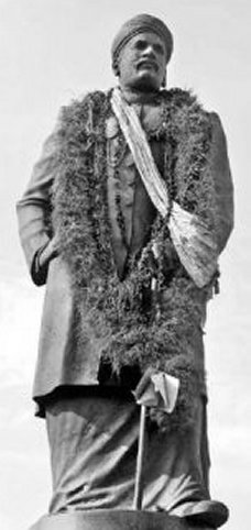
Mahatma Ayyankali was an Indian politician, prominent social reformer, educator, economist, lawmaker, and revolutionary leader. He worked for the advancement of the oppressed people in the princely state of Travancore. His struggle resulted in many changes that improved the socio-political structure of Kerala. His determined and relentless efforts changed the lives of Dalits. He is known as the King of Pulaya.

Kazhakoottam is a major urban area in the capital city of Thiruvananthapuram, Kerala state, India. The largest IT Park of the country in terms of developed area Technopark along with Technocity an upcoming integrated IT township is situated here. Hence it is known as the Information Technology capital of Kerala. It is one of the fastest growing area of the state.

Thiruvananthapuram District is the southernmost district in the Indian state of Kerala. The district was created in 1949, with its headquarters in the city of Thiruvananthapuram, which is also Kerala's administrative centre. The present district was created in 1956 by separating the four southernmost Taluks of the erstwhile district to form Kanyakumari district. The city of Thiruvananthapuram is also known as the Information technology capital of the State, since it is home to the first and largest IT park in India, Technopark, established in 1990. The district is home to more than 9% of total population of the state.
Edakkad is part of the Kannur Municipal Corporation in Kannur District of Kerala state, in India.

Chengannur is a municipality in the Alappuzha district of Kerala, India. It is located 43 km (26.7 mi) south east of the district headquarters in Alappuzha and about 98 km (60.9 mi) north of the state capital Thiruvananthapuram. As per the 2011 Indian census, Chengannur has a population of 23,466 people, and a population density of 1,607/km2 (4,160/sq mi).
Puthenthope is a coastal village in Thiruvananthapuram district in Kerala, India, and situated 19 km (12 mi) northwest of city centre, 16 km from Thiruvananthapuram International Airport. The village is mostly covered with coconut palms and cashew trees. Its western side edges the Arabian Sea, while the east is separated by Parvathi Puthanar, a manmade canal completed during the time of Regent Sethu Lakshmi Bhai of Travancore Kingdom. Access to National Highway and a railway station is as short as 2 km (1.2 mi) and the VSSC of the Indian Space Research Organisation is close by. There are two man made hills — one on the south (Thekkekkunnu)and the other on the north (Vadakkekkunnu), which are believed to have been made during the time of Portuguese.India's first DNA-Barcoding Centre, set up at bio-informatic centre for Tropical Garden and Research institute at Puthenthope. Famous Malayalam Cine Artist Alencier Ley Lopez hails from Puthenthope.

Kadinamkulam is a panchayat and the northern suburb of Trivandrum City. It is one of the residential and industrial area of Trivandrum City in Kerala, India. It is situated 22 km north of Trivandrum, 20 km from Varkala, 20 km from the Trivandrum International Airport and 22 km from Trivandrum Central Railway station and bus station. National Highway 66 is also 8 km away. Kadinamkulam is surrounded by Kadinamkulam Kayal to the east, the Arabian Sea to the west, Puthucurichy to the north and Channankara to the south. Kadinamkulam forms part of Kadinamkulam panchayat of Trivandrum district. Kinfra international apparel park, Marian Engineering College etc. are situated in Kadinamkulam.
Kariavattom is an area of Trivandrum city the capital of Kerala, India. Trivandrum International Stadium the largest international stadium of Kerala is situated in Karyavattom.
Kaniyamkunnu is a historical place in Kerala, India.

St. Andrews is a seaside hamlet located in the city of Thiruvananthapuram, Thiruvananthapuram district of Kerala. It is situated 19 km (12 mi) northwest of city centre, 16 km (9.9 mi) from Thiruvananthapuram International Airport. It is known for its pristine beach. It is a hamlet with a "melting pot" of several cultures and traditions. The village is mostly covered with coconut palms. Its western side edges the Arabian sea, while the east is separated by Parvathi Puthannaar, a manmade canal completed during the time of Regent Sethu Lakshmi Bayi of Travancore Kingdom. Access to National Highway and a railway station is as short as 3 km (1.9 mi) and the Vikram Sarabhai Space Center (VSSC) of the Indian Space Research Organization (ISRO) is close by.
Ooruttambalam is a locality near Nemom, a suburban area of Trivandrum, capital of Kerala, India.
Vembayam is a village in Thiruvananthapuram district in the state of Kerala, India.

Avanavancherry is a village in Thiruvananthapuram district in the state of Kerala, India.

Chirayinkeezhu is a town in Thiruvananthapuram district in the Indian state of Kerala. It was also hometown of famous Malayalam Film actor Prem Nazir. It is the seat of Chirayinkeezhu taluk.
Pallippuram is a northern suburb of Trivandrum city of Trivandrum district, Kerala. It is one of the fastest urbanising area of the Trivandrum UA.Technocity is situated in this area.
Vettuthura is a suburb of Thiruvananthapuram, the capital of Kerala, India. The main job in this area is fishing.
Thiruvarambu is a village in the town of Thiruvattar town panchyat, Tamil Nadu.

Transport in Kollam includes various modes of road, rail and water transportation in the city and its suburbs. State-owned Kerala State Road Transport Corporation buses, private buses, Indian Railways, state-owned Kerala State Water Transport Department boats & ferry, taxis and auto rickshaws are serving the city of Kollam. The city had a strong commercial reputation since the days of the Phoenicians and Romans. Ibn Battuta mentioned Kollam Port as one of the five Indian ports he had seen during the course of his twenty-four year travels.

